A low pressure area (LPA) spotted east of Mindanao is expected to bring unsettled weather across the island, with state weather bureau Philippine Atmospheric, Geophysical and Astronomical Services Administration warning of possible flash floods and landslides amid isolated thunderstorms.
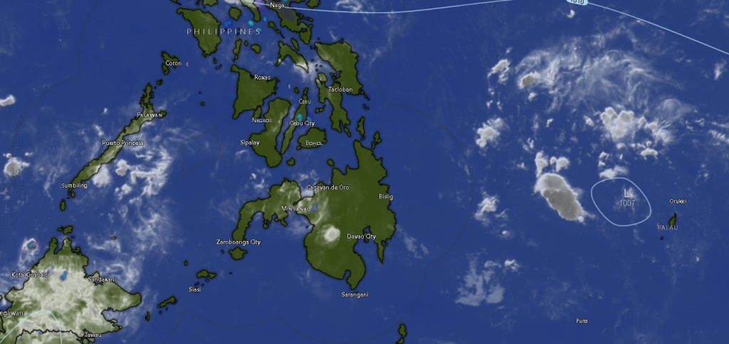
In its 5:00 AM regional forecast issued Wednesday, PAGASA said the LPA was last estimated at around 910 kilometers east of Northeastern Mindanao as of 3:00 PM the previous day. While the weather disturbance has yet to directly affect land, it is enhancing the easterlies—warm winds coming from the Pacific Ocean—which are currently influencing weather patterns across Mindanao.
Widespread Cloudiness, Scattered Rainfall
Forecasters said Mindanao will generally experience partly cloudy to cloudy skies with isolated rainshowers or thunderstorms throughout the forecast period, which runs until 5:00 AM Thursday.
“These thunderstorms may trigger flash floods or landslides, particularly in areas prone to these hazards,” PAGASA said.
Wind conditions across the island will remain light to moderate, blowing from the northeast to north in eastern sections, and from the east to northeast elsewhere. Coastal waters are expected to be slight to moderate, with wave heights ranging from 0.6 to 2.1 meters.
Zamboanga Peninsula: Warm with Passing Showers
In Zamboanga Peninsula, including Zamboanga City, skies will remain partly cloudy to cloudy with occasional rainshowers or thunderstorms. Temperatures will range between 24°C and 33°C. Similar conditions are expected in Zamboanga del Norte, Zamboanga del Sur, Zamboanga Sibugay, and Isabela City.
Northern Mindanao: Mild to Warm Temperatures
Across Northern Mindanao, including Bukidnon and Camiguin, similar weather conditions will prevail, with temperatures ranging from 20°C to 33°C. Coastal provinces such as Lanao del Norte, Misamis Occidental, and Misamis Oriental will also experience slight to moderate seas.
Davao Region: Higher Daytime Temperatures
In the Davao Region, including Davao City and surrounding provinces such as Davao del Norte, Davao del Sur, and Davao Oriental, temperatures may climb as high as 34°C. Thunderstorms are expected to develop intermittently, especially in the afternoon or evening.
SOCCSKSARGEN and Caraga: Continued Rain Threat
The SOCCSKSARGEN region—including North Cotabato, South Cotabato, Sultan Kudarat, and Sarangani—will also experience partly cloudy to cloudy skies with scattered rainshowers. Temperatures will range from 24°C to 34°C.
Meanwhile, in the Caraga Region, including Agusan del Norte, Agusan del Sur, Surigao del Norte, Surigao del Sur, and Dinagat Islands, similar weather patterns are expected, with slightly cooler temperatures ranging from 23°C to 32°C.
BARMM: Rainshowers Across Island Provinces
The Bangsamoro region or BARMM will also see unsettled weather conditions. Areas such as Cotabato City, Basilan, Lanao del Sur, Sulu, Tawi-Tawi, Maguindanao del Norte, and Maguindanao del Sur will experience occasional rainshowers and thunderstorms, with temperatures ranging from 21°C to 34°C.
Advisory to the Public
PAGASA urged residents, especially those in low-lying and mountainous areas, to remain vigilant against possible flooding and landslides during periods of intense rainfall. Fisherfolk and small sea vessels are also advised to exercise caution when venturing out to sea due to moderate wave conditions.
While no tropical cyclone has formed from the LPA as of this time, authorities continue to monitor its development and potential impact on the country.