
MINDANAO — Localized thunderstorms are expected to affect large parts of Mindanao over the next 24 hours, with the Philippine Atmospheric, Geophysical and Astronomical Services Administration (PAGASA) warning communities of possible flash floods and landslides in areas hit by severe thunderstorms.
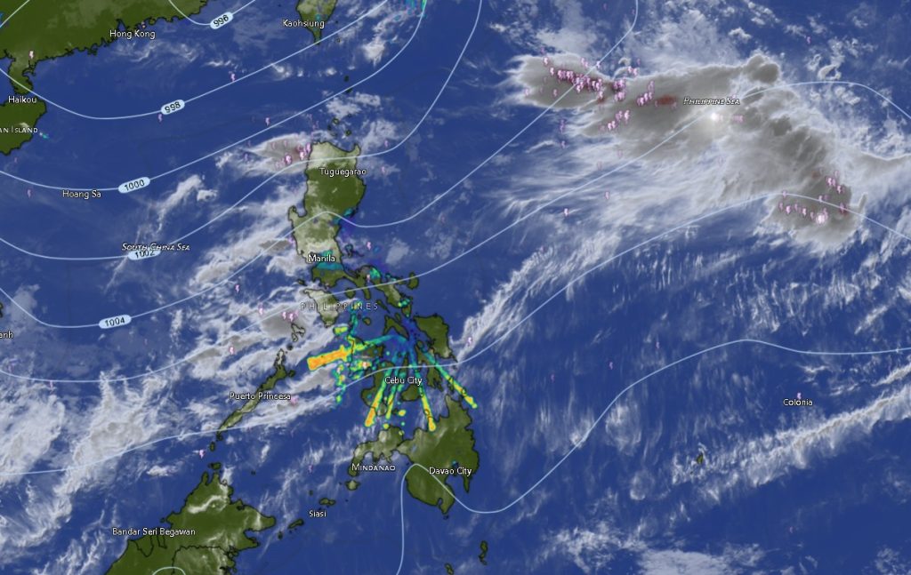
In its Regional Weather Forecast for Mindanao issued at 5:00 a.m. on August 11, 2026, PAGASA said Mindanao will generally experience partly cloudy to cloudy skies with isolated rainshowers or localized thunderstorms from Tuesday morning until 5:00 a.m. Wednesday.
The weather disturbance is expected to be highly localized, meaning some areas may experience sudden heavy rain and thunderstorms while nearby locations may remain relatively dry. PAGASA emphasized that severe thunderstorms could trigger rapid rises in rivers and waterways, flash flooding, and landslides, particularly in low-lying, mountainous and landslide-prone communities.
Residents are urged to remain alert, especially during periods of intense rainfall, and to closely monitor local disaster risk reduction and management offices for possible warnings or evacuation instructions.
Strong winds and rough seas expected
Aside from thunderstorms, PAGASA is also forecasting moderate to strong winds from the south to southwest across Mindanao.
These winds are expected to produce moderate to rough seas, with wave heights generally ranging from 1.2 to 3.1 meters.
The condition may pose risks to small fishing boats, passenger vessels and other light watercraft, particularly during periods of thunderstorms and stronger wind gusts. Fisherfolk and coastal communities are advised to exercise caution and monitor marine weather conditions before venturing into open waters.
Tropical Storm Peilou remains outside the Philippine Area of Responsibility
PAGASA also reported Tropical Storm Peilou (2616), which remained outside the Philippine Area of Responsibility as of the latest monitoring.
Peilou was located approximately 3,000 kilometers east of extreme Northern Luzon, near 20.9°N, 150.8°E, with maximum sustained winds of 75 kilometers per hour near the center and gustiness reaching 90 km/h.
The tropical storm was moving eastward at 35 km/h.
Based on its reported location and movement, Peilou was not directly affecting Mindanao’s weather at the time of the forecast. The weather agency’s Mindanao forecast instead points to localized atmospheric instability producing isolated rainshowers and thunderstorms across the region.
Weather outlook across Mindanao
The weather pattern will be generally similar across the different provinces, with temperatures varying depending on location and elevation.
In the Zamboanga Peninsula, Zamboanga City is expected to experience temperatures of 24°C to 31°C, while Zamboanga del Norte may reach 25°C to 31°C. Zamboanga del Sur is forecast at 25°C to 32°C, Zamboanga Sibugay at 26°C to 32°C, and Isabela City at 25°C to 31°C.
Across Northern Mindanao, Bukidnon is expected to have cooler temperatures of around 21°C to 29°C, while Camiguin is forecast at 27°C to 31°C. Lanao del Norte may see 25°C to 31°C, Misamis Occidental 25°C to 33°C, and Misamis Oriental 25°C to 34°C.
In the Davao Region, Metro Davao is expected to experience temperatures of 26°C to 31°C, while Davao del Norte may range from 25°C to 30°C. Davao del Sur is forecast at 25°C to 31°C, Davao Oriental at 25°C to 32°C, Davao de Oro at 23°C to 30°C, and Davao Occidental at 24°C to 32°C.
For SOCCSKSARGEN, North Cotabato is forecast at 22°C to 33°C, South Cotabato at 24°C to 32°C, Sultan Kudarat at 24°C to 32°C, and Sarangani at 25°C to 31°C.
In Caraga, Agusan del Norte may reach 27°C to 35°C, while Agusan del Sur is expected to range from 25°C to 32°C. Surigao del Norte and Surigao del Sur are forecast to reach around 26°C to 33°C, while Dinagat Islands may experience temperatures of 26°C to 33°C.
Across the Bangsamoro Autonomous Region in Muslim Mindanao (BARMM), Cotabato City is forecast at 23°C to 31°C, Basilan at 26°C to 32°C, Lanao del Sur at 22°C to 30°C, Sulu at 26°C to 31°C, Tawi-Tawi at 27°C to 31°C, Maguindanao del Norte at 24°C to 32°C, and Maguindanao del Sur at 25°C to 32°C.
Most coastal areas in the region will continue to experience moderate to rough seas as southwesterly winds persist.
Communities urged to stay weather-ready
PAGASA’s forecast highlights the continued need for preparedness as thunderstorms can develop rapidly and bring intense rainfall within a short period.
Residents living near rivers, creeks and other waterways are advised to remain vigilant for sudden water level increases. Communities located near steep slopes and areas with a history of landslides should also be prepared for possible ground movement following prolonged or intense rainfall.
Motorists are likewise urged to exercise caution on roads affected by heavy rain, reduced visibility or flooding.
The public is encouraged to rely on official updates from PAGASA and local disaster management authorities, particularly when thunderstorms become severe.
The forecast is valid from 5:00 a.m. August 11 until 5:00 a.m. August 12, 2026, with conditions subject to change as weather systems evolve.