
MINDANAO — Residents across Mindanao are being warned to remain alert for localized thunderstorms, heavy downpours, flash floods and possible landslides as generally unsettled weather is expected across the region over the next 24 hours.
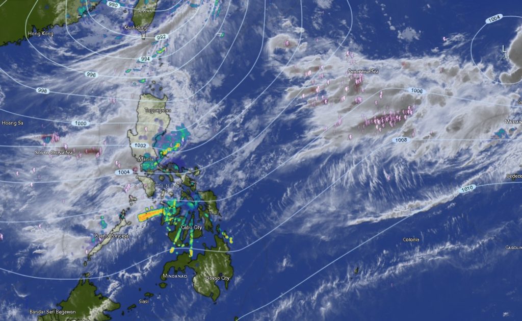
The Philippine Atmospheric, Geophysical and Astronomical Services Administration (PAGASA) Mindanao Regional Services Division (MINPRSD) said Mindanao will experience partly cloudy to cloudy skies with isolated rainshowers or localized thunderstorms from 5:00 a.m. Monday, August 10, until 5:00 a.m. Tuesday, August 11, 2026.
While the thunderstorms are expected to be localized rather than widespread, PAGASA cautioned that severe thunderstorms could still produce intense rainfall capable of triggering flash floods and landslides, particularly in vulnerable communities, low-lying areas and locations near rivers, creeks and steep or mountainous terrain.
The weather agency also forecast moderate to strong winds from the south to southwest over much of Mindanao, with coastal waters expected to remain moderate to rough, with waves ranging from approximately 1.2 to 3.1 meters.
These conditions could affect fishing, small sea vessels and other maritime activities, particularly in exposed coastal areas.
Tropical Storm Peilou remains outside the Philippine Area of Responsibility
PAGASA is also monitoring Tropical Storm Peilou (2616), which remains well outside the Philippine Area of Responsibility (PAR).
As of 3:00 p.m. on August 9, Peilou was located approximately 2,200 kilometers east of extreme Northern Luzon, near 21.1°N, 143.0°E.
The tropical cyclone had maximum sustained winds of 65 kilometers per hour near its center, with gustiness reaching 80 kph. It was moving east-southeastward at 25 kph.
Given its location far east of the country, the storm is not currently the direct cause of the thunderstorms affecting Mindanao. However, PAGASA continues to monitor its movement as part of the broader tropical weather situation in and around the Philippine monitoring area.
Western and northern Mindanao face recurring thunderstorms
Across the Zamboanga Peninsula, including Zamboanga City, Zamboanga del Norte, Zamboanga del Sur, Zamboanga Sibugay and Isabela City, residents can expect partly cloudy to at times cloudy conditions with rainshowers or thunderstorms.
Winds are forecast to be moderate to strong from the south to southwest, while coastal waters will be moderate to rough. Temperatures are expected to range from 25°C to 33°C depending on the locality and period.
In Northern Mindanao, Bukidnon, Camiguin, Lanao del Norte, Misamis Occidental and Misamis Oriental are likewise expected to experience isolated rainshowers and thunderstorms.
Bukidnon could see temperatures between 21°C and 32°C, while Misamis Oriental could reach as high as 36°C during the warmer part of the forecast period.
Davao Region also under thunderstorm watch
The entire Davao Region is expected to remain vulnerable to localized thunderstorms.
Metro Davao, Davao del Norte, Davao del Sur and Davao Oriental will experience partly cloudy to cloudy skies with isolated rainshowers or thunderstorms, accompanied by moderate to strong winds generally coming from the south to southwest.
Coastal waters in the region are expected to be moderate to rough, with temperatures generally ranging from the mid-20s to low 30s Celsius.
Davao del Sur is forecast to experience temperatures of 25°C to 33°C, while Davao Oriental may reach 33°C during the warmer period.
Davao del Norte is expected to reach up to 33°C, while Metro Davao may experience temperatures between 26°C and 33°C.
SOCCSKSARGEN braces for thunderstorms
Thunderstorm activity is also expected across North Cotabato, South Cotabato, Sultan Kudarat and Sarangani.
The provinces will experience partly cloudy to at times cloudy skies with rainshowers or thunderstorms, while winds will generally blow from the south to southwest at moderate to strong speeds.
Temperatures could reach 33°C in North Cotabato, 32°C in South Cotabato, 33°C in Sultan Kudarat, and 31°C in Sarangani.
Coastal waters in the affected provinces are expected to remain moderate to rough.
Caraga can expect rainshowers and thunderstorms
The Caraga provinces are also included in the regional thunderstorm outlook.
Agusan del Norte, Agusan del Sur, Surigao del Norte, Surigao del Sur and Dinagat Islands are expected to experience partly cloudy to cloudy skies with isolated rainshowers or thunderstorms.
The region could experience some of the warmer temperatures in Mindanao, with maximum temperatures reaching 36°C in parts of Agusan del Norte and Surigao del Norte and 36°C in Surigao del Sur.
Despite the warmer conditions, residents should remain alert because thunderstorms can develop rapidly and produce sudden heavy rainfall, strong winds and lightning.
BARMM provinces also affected
The weather disturbance is expected to affect much of the Bangsamoro Autonomous Region in Muslim Mindanao (BARMM).
Cotabato City, Basilan, Lanao del Sur, Sulu, Tawi-Tawi, Maguindanao del Norte and Maguindanao del Sur are forecast to experience partly cloudy to at times cloudy skies with rainshowers or thunderstorms.
Winds will generally be moderate to strong from the south to southwest, while coastal waters in exposed areas will be moderate to rough.
Temperatures are expected to reach around 33°C to 35°C in several lowland areas, although Lanao del Sur will remain relatively cooler, with temperatures forecast at around 23°C to 28°C.
Public urged to monitor thunderstorms closely
PAGASA’s warning comes as localized thunderstorms can produce rapidly changing weather conditions even when skies initially appear partly cloudy.
Residents in flood-prone and landslide-prone communities are advised to monitor developments closely, particularly when thunderstorms become persistent or rainfall intensifies.
Motorists should also exercise caution on roads during heavy rain because sudden downpours can reduce visibility and cause temporary flooding.
Communities near rivers, waterways and steep slopes should be especially vigilant for sudden rises in water levels and signs of possible slope instability.
For coastal communities, fishermen and operators of small boats are urged to assess conditions carefully before venturing out to sea because moderate to rough seas and strong winds could make maritime travel hazardous.
PAGASA emphasized that localized thunderstorms can develop quickly, making continuous monitoring of official weather advisories particularly important throughout the forecast period.
The Mindanao Regional Weather Forecast is valid from 5:00 a.m. August 10 until 5:00 a.m. August 11, 2026.
PAGASA said residents may obtain further information through its official weather bulletins and monitoring channels.