
MINDANAO — Large parts of Mindanao will continue to experience generally unsettled weather on Wednesday, August 12, with partly cloudy to cloudy skies, scattered rainshowers and localized thunderstorms expected across the island, according to the Philippine Atmospheric, Geophysical and Astronomical Services Administration (PAGASA).
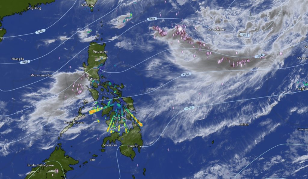
In its Regional Weather Forecast for Mindanao (MINPRSD) issued at 5:00 a.m. on August 12, PAGASA said the forecast is valid from 5:00 a.m. Wednesday until 5:00 a.m. Thursday.
The weather agency warned that flash floods and landslides are possible, particularly in areas affected by severe thunderstorms. Residents in low-lying, flood-prone and landslide-prone communities were urged to remain alert, especially during periods of heavy rainfall.
The forecast calls for light to moderate winds coming from the south to southwest over most areas of Mindanao. Coastal waters are expected to range from slight to moderate, with wave heights generally between 0.6 and 1.8 meters.
Rain and thunderstorms expected across western Mindanao
In the Zamboanga Peninsula, Zamboanga City and the provinces of Zamboanga del Norte, Zamboanga del Sur and Zamboanga Sibugay are expected to have partly cloudy skies becoming cloudy at times, with rainshowers or thunderstorms possible.
Temperatures in the area are forecast to range from around 25°C to 35°C, depending on the locality and time of day.
Zamboanga del Norte could reach up to 35°C, while Zamboanga City may reach 34°C. Zamboanga del Sur and Zamboanga Sibugay could reach highs of 33°C, while Isabela City may experience temperatures between 26°C and 33°C.
Winds are expected to remain light to moderate from the south to southwest, with slight to moderate coastal conditions.
Northern Mindanao faces similar conditions
The same weather pattern is expected over Bukidnon, Camiguin, Lanao del Norte, Misamis Occidental and Misamis Oriental.
Bukidnon is forecast to remain relatively cooler, with temperatures ranging from 19°C to 32°C. Rainshowers or thunderstorms may develop despite periods of partly cloudy weather.
Camiguin will experience moderate to strong south-to-southwest winds, with coastal waters expected to be moderate to rough. Temperatures may range from 26°C to 33°C.
Lanao del Norte may experience temperatures of 25°C to 33°C, while Misamis Occidental could reach 34°C. Misamis Oriental is expected to be among the warmer areas, with temperatures potentially reaching 35°C.
Davao Region remains vulnerable to thunderstorms
Across the Davao Region, including Metro Davao, Davao del Norte, Davao del Sur and Davao Oriental, partly cloudy to cloudy conditions with rainshowers or thunderstorms are also expected.
Temperatures are generally forecast to range from 25°C to 34°C, although Davao del Norte could reach up to 34°C.
Davao de Oro is expected to experience temperatures of 24°C to 34°C, while Davao Occidental could see temperatures between 24°C and 33°C.
PAGASA also forecast light to moderate south-to-southwest winds and slight to moderate coastal conditions throughout the region.
Hotter conditions possible in parts of SOCCSKSARGEN
In SOCCSKSARGEN, North Cotabato, South Cotabato, Sultan Kudarat and Sarangani will likewise experience partly cloudy to cloudy skies with possible rainshowers and thunderstorms.
South Cotabato could reach a high of 36°C, making it one of the warmest areas covered by the forecast.
Surigao del Norte and Surigao del Sur may also reach temperatures of 36°C, while Agusan del Sur could reach 35°C.
Sarangani is forecast to have temperatures between 26°C and 32°C, while Sultan Kudarat may reach 34°C.
Caraga provinces to see rainshowers and thunderstorms
The entire Caraga Region is also expected to remain under partly cloudy to cloudy skies, with rainshowers or thunderstorms possible.
Agusan del Norte may experience temperatures ranging from 26°C to 35°C, while Agusan del Sur could reach 35°C.
Surigao del Norte and Surigao del Sur are forecast to reach highs of 36°C, while Dinagat Islands could reach 34°C.
Despite the warm temperatures, localized thunderstorms could produce sudden heavy rainfall in some communities.
BARMM areas also included in the thunderstorm forecast
PAGASA also placed the Bangsamoro Autonomous Region in Muslim Mindanao (BARMM) under the same general weather pattern.
Cotabato City, Basilan, Lanao del Sur, Sulu, Tawi-Tawi, Maguindanao del Norte and Maguindanao del Sur are all expected to experience partly cloudy skies becoming cloudy at times, with rainshowers or thunderstorms.
Temperatures could reach 34°C in Cotabato City and Maguindanao del Norte, while Maguindanao del Sur may reach 34°C.
Lanao del Sur is expected to be comparatively cooler, with temperatures ranging from 24°C to 32°C.
Sulu and Tawi-Tawi could reach highs of 33°C, while Basilan may experience temperatures between 26°C and 33°C.
Residents urged to monitor thunderstorms
PAGASA’s warning on possible flash floods and landslides underscores the need for residents to closely monitor rapidly developing thunderstorms.
Localized thunderstorms can bring intense rainfall over a relatively short period, potentially causing rapid rises in rivers and waterways, flooding in low-lying areas, poor visibility on roads, slippery conditions and landslides in vulnerable communities.
Residents in mountainous areas and communities near rivers, creeks and steep slopes are advised to exercise caution whenever thunderstorms become severe.
Motorists should also be prepared for sudden reductions in visibility and hazardous road conditions during heavy downpours.
For coastal communities and maritime operators, PAGASA said most Mindanao waters will remain under slight to moderate sea conditions, although Camiguin is expected to experience moderate to rough seas with moderate to strong south-to-southwest winds.
PAGASA advised the public to continue monitoring official weather bulletins and local disaster risk reduction and management offices for possible warnings as thunderstorms develop.