MANILA, Philippines — A Low Pressure Area (LPA) spotted off the eastern coast of Mindanao is bringing widespread rains and thunderstorms across much of the island, prompting warnings of possible flooding and landslides, according to the Philippine Atmospheric Geophysical and Astronomical Services Administration.
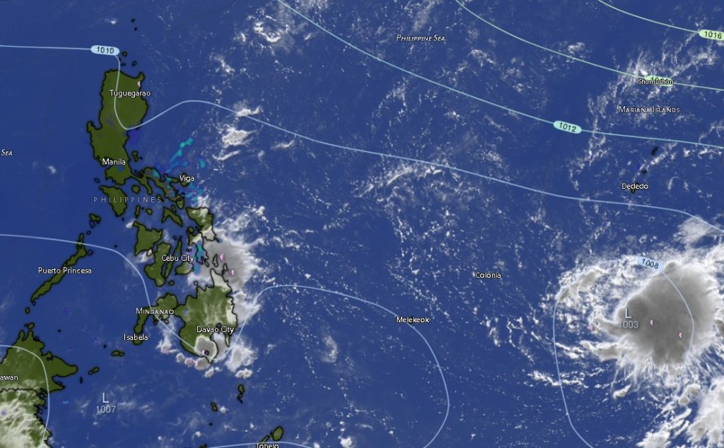
In its 5:00 a.m. regional weather bulletin on Thursday, PAGASA said the LPA was last estimated 120 kilometers southeast of Hinatuan (7.7°N, 127.2°E)** as of 3:00 a.m. The weather disturbance continues to enhance rain-bearing systems over Mindanao, while easterlies—warm winds coming from the Pacific—are affecting the rest of the country.
Widespread Rainfall Across Key Regions
The state weather bureau said Caraga, Northern Mindanao, Davao Region, and Zamboanga Peninsula will experience cloudy skies with scattered rains and thunderstorms throughout the day and into the night.
Affected provinces include:
- Caraga Region: Agusan del Norte, Agusan del Sur, Surigao del Norte, Surigao del Sur, Dinagat Islands
- Northern Mindanao: Bukidnon, Camiguin, Lanao del Norte, Misamis Occidental, Misamis Oriental
- Davao Region: Davao de Oro, Davao del Norte, Davao del Sur, Davao Oriental, Davao Occidental, Metro Davao
- Zamboanga Peninsula: Zamboanga del Norte, Zamboanga del Sur, Zamboanga Sibugay, and Isabela City
Rainfall in these areas may range from moderate to at times heavy, raising the likelihood of flash floods and landslides, especially in mountainous and low-lying communities.
Intermittent Rains Elsewhere in Mindanao
Meanwhile, the rest of Mindanao—including parts of SOCCSKSARGEN and the Bangsamoro Autonomous Region in Muslim Mindanao (BARMM)—will see partly cloudy to cloudy skies with isolated rainshowers or thunderstorms.
Provinces such as North Cotabato, South Cotabato, Sultan Kudarat, Sarangani, Basilan, Lanao del Sur, Maguindanao del Norte and Sur, and Cotabato City may experience sudden heavy downpours, particularly in the afternoon or evening, which could still trigger localized flooding or landslides during severe thunderstorms.
Temperature and Wind Conditions
Across Mindanao, temperatures are expected to range between 22°C and 34°C, with slightly cooler conditions in upland areas like Bukidnon and warmer conditions in urban centers such as Metro Davao.
Winds will be light to moderate, generally coming from the northeast to north, while coastal waters across the island will remain slight to moderate, with wave heights ranging from 0.6 to 2.1 meters.
Sea Travel and Public Safety Advisory
Authorities advise fisherfolk and small sea vessels to exercise caution due to moderate sea conditions, particularly along the eastern seaboard where the LPA’s influence is stronger.
Residents in flood-prone and landslide-prone areas are urged to:
- Monitor official weather updates
- Prepare for possible evacuations
- Avoid crossing swollen rivers and flooded roads
Outlook
The LPA remains under monitoring for possible intensification, although no tropical cyclone has been declared as of this writing. PAGASA continues to track its movement and advises the public to stay alert for further updates.
As the system lingers near eastern Mindanao, rainy conditions are expected to persist over the next 24 hours, with the potential for worsening weather should the disturbance strengthen.