
The Southwest Monsoon, locally known as Habagat, is expected to continue affecting parts of western and northern Mindanao, bringing cloudy skies, scattered rains, and thunderstorms to several provinces, while the rest of the island remains vulnerable to sudden rain showers and severe thunderstorms.
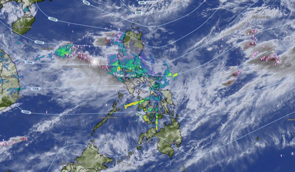
In its 5:00 a.m. regional weather forecast issued August 9, 2026, the Philippine Atmospheric, Geophysical and Astronomical Services Administration (PAGASA) said the Southwest Monsoon is directly affecting the Zamboanga Peninsula, Misamis Occidental, Lanao del Norte, and Lanao del Sur. The rest of Mindanao is being affected by localized thunderstorms.
PAGASA warned that moderate to at times heavy rains over areas under the influence of the Southwest Monsoon could trigger flash floods and landslides, particularly in communities located near rivers, waterways, steep slopes, and other landslide-prone areas.
For the remainder of Mindanao, partly cloudy to cloudy conditions are expected, with isolated rain showers or localized thunderstorms. PAGASA likewise cautioned that severe thunderstorms could generate sudden heavy rainfall, potentially resulting in flash floods and landslides even in areas not directly affected by the monsoon.
Western Mindanao faces more persistent rainfall
The Zamboanga Peninsula is expected to experience the most persistent wet conditions during the forecast period.
Zamboanga City, Zamboanga del Norte, Zamboanga del Sur, Zamboanga Sibugay, and Isabela City are forecast to have cloudy skies accompanied by rain showers and thunderstorms. Moderate to strong winds from the south to southwest are also expected, with coastal waters ranging from moderate to rough.
Temperatures in the peninsula are generally expected to remain between the mid-20s and low-30s Celsius, although daytime temperatures could reach 35°C in Isabela City during the latter part of the forecast period.
The same weather pattern is expected in Misamis Occidental, Lanao del Norte, and Lanao del Sur, where cloudy skies, rain showers, and thunderstorms are forecast throughout the period.
Misamis Occidental could see temperatures ranging from 25°C to 33°C, while Lanao del Norte could experience 26°C to 32°C. Lanao del Sur is expected to remain comparatively cooler, with temperatures between 23°C and 30°C.
Thunderstorms remain possible across the rest of Mindanao
Even areas outside the main monsoon-affected zone are not expected to remain completely dry.
PAGASA forecasts partly cloudy to at times cloudy skies over much of Northern Mindanao, Davao Region, SOCCSKSARGEN, Caraga, and the Bangsamoro Autonomous Region in Muslim Mindanao (BARMM), with rain showers or localized thunderstorms possible.
In Bukidnon, temperatures could range from 21°C to 31°C, while Camiguin could reach 33°C. Misamis Oriental is expected to experience temperatures of around 25°C to 34°C.
Across the Davao Region, Metro Davao and Davao del Norte could reach highs of 33°C to 34°C. Davao del Sur is expected to range from 23°C to 33°C, while Davao Oriental could see temperatures between 22°C and 32°C.
The forecast also covers Davao de Oro and Davao Occidental, where isolated rain showers and thunderstorms are possible amid moderate to strong southerly to southwesterly winds.
In SOCCSKSARGEN, North Cotabato could reach 32°C, while South Cotabato and Sultan Kudarat could climb to around 33°C. Sarangani is forecast to have temperatures between 25°C and 32°C.
Similar conditions are expected throughout Caraga, including Agusan del Norte, Agusan del Sur, Surigao del Norte, Surigao del Sur, and the Dinagat Islands. Some areas could experience daytime temperatures reaching 35°C, particularly in Agusan del Norte and Surigao del Norte.
BARMM areas remain exposed to thunderstorms
PAGASA also expects partly cloudy to at times cloudy conditions with rain showers or thunderstorms in several parts of BARMM.
Cotabato City, Basilan, Sulu, Tawi-Tawi, Maguindanao del Norte, and Maguindanao del Sur are forecast to experience localized rain showers or thunderstorms.
Lanao del Sur, however, remains under the more direct influence of the Southwest Monsoon and is forecast to experience cloudy skies with rain showers and thunderstorms, along with moderate to strong winds from the south to southwest.
Coastal conditions across many parts of Mindanao are expected to remain moderate to rough, with waves generally ranging from 1.2 to 3.0 meters. The combination of strong winds and rough seas could pose risks to small fishing boats, passenger vessels, and other maritime activities.
Typhoon Dolphin remains outside PAR
Meanwhile, PAGASA is monitoring Typhoon Dolphin (2613), which remained outside the Philippine Area of Responsibility (PAR) as of the latest information provided in the regional forecast.
Dolphin was located approximately 825 kilometers northeast of extreme Northern Luzon, at 26.9°N, 125.2°E. It had maximum sustained winds of 150 kilometers per hour near the center and gustiness of up to 185 km/h, while moving west-southwestward at 15 km/h.
A separate tropical depression was also being monitored approximately 3,055 kilometers east of extreme Northern Luzon. It had maximum sustained winds of 45 km/h, gustiness of up to 55 km/h, and was moving eastward at 50 km/h.
Based on the regional forecast provided, neither system is identified as the direct cause of the rainfall currently affecting Mindanao. The dominant weather drivers for the island remain the Southwest Monsoon and localized thunderstorms.
Residents urged to remain alert
With widespread thunderstorms and the possibility of moderate to heavy rainfall, residents in flood- and landslide-prone communities are urged to closely monitor official weather advisories, particularly when thunderstorms develop nearby.
Local disaster risk reduction and management offices, barangay authorities, motorists, farmers, and communities near waterways should remain prepared for sudden changes in weather conditions.
PAGASA’s forecast remains valid from 5:00 a.m. August 9 until 5:00 a.m. August 10, 2026, with conditions subject to change depending on the development of the monsoon and thunderstorms across the region.
Mindanao may not be under the direct influence of a tropical cyclone, but the combination of the Southwest Monsoon, strong winds, thunderstorms, and moderate to rough seas means hazardous weather conditions remain possible across several parts of the island.