CAGAYAN DE ORO CITY, June 21, 2026 — Large parts of Mindanao are expected to experience cloudy skies, scattered rain showers, and thunderstorms over the next 24 hours as the trough of Tropical Storm Mekkhala and the enhanced Southwest Monsoon continue to affect the region, according to the latest forecast issued by the Philippine Atmospheric, Geophysical and Astronomical Services Administration (PAGASA).
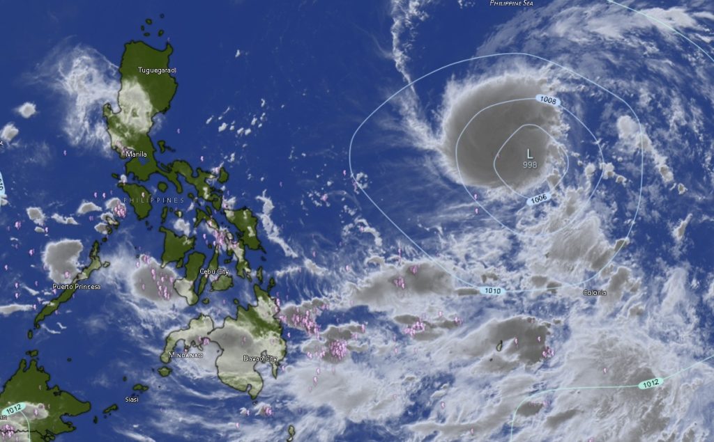
As of 3 p.m. Saturday, Tropical Storm Mekkhala (international name: Mekkhala) was located approximately 1,480 kilometers east of Southeastern Luzon, packing maximum sustained winds of 85 kilometers per hour near the center and gusts reaching up to 105 kilometers per hour. The storm was moving westward at 15 kilometers per hour and remained outside the Philippine Area of Responsibility (PAR).
Although still far from the country, the weather system’s trough is already influencing weather conditions in eastern Mindanao.
PAGASA said the Caraga Region and the Davao Region will experience cloudy skies with scattered rains and thunderstorms due to the trough of Tropical Storm Mekkhala. Residents in these areas were advised to remain vigilant as moderate to occasionally heavy rainfall could trigger flash floods and landslides, particularly in low-lying, flood-prone, and mountainous communities.
Meanwhile, the Southwest Monsoon, locally known as “Habagat,” continues to affect the western and southern sections of Mindanao. The weather bureau said the Zamboanga Peninsula, the Bangsamoro Autonomous Region in Muslim Mindanao (BARMM), SOCCSKSARGEN, and Lanao del Norte will also experience cloudy skies accompanied by scattered rain showers and thunderstorms.
The monsoon rains are expected to bring periods of moderate to heavy precipitation that may lead to flooding, rising river levels, and landslides in vulnerable areas.
For the rest of Mindanao, partly cloudy to cloudy skies with isolated rain showers and thunderstorms are forecast due to localized thunderstorm activity. PAGASA warned that severe thunderstorms may still generate flash floods and landslides despite generally fair weather conditions during parts of the day.
Davao, Caraga Under Enhanced Rainfall Threat
Several provinces in the Davao Region, including Davao del Norte, Davao del Sur, Davao de Oro, Davao Oriental, Davao Occidental, and Metro Davao, are expected to experience persistent cloudy skies with rain showers and thunderstorms through Monday morning.
Daytime temperatures across the region are forecast to range from 23°C to 35°C, with Davao de Oro expected to register the highest temperature at 35°C.
In the Caraga Region, Surigao del Norte, Surigao del Sur, Dinagat Islands, and Agusan del Norte are likewise expected to experience cloudy conditions and thunderstorms. Agusan del Norte and Surigao del Norte may see temperatures reaching as high as 35°C despite the rainy weather.
Monsoon Rains Continue Over Western Mindanao
The Zamboanga Peninsula remains under the influence of the Southwest Monsoon, bringing cloudy skies and frequent rain showers.
PAGASA forecasts temperatures ranging from 23°C to 33°C across Zamboanga City, Zamboanga del Norte, Zamboanga del Sur, Zamboanga Sibugay, and Isabela City.
Lanao del Norte, which lies along the western section of Northern Mindanao, is also expected to experience similar weather conditions with temperatures ranging between 24°C and 32°C.
Across BARMM, including Basilan, Sulu, Tawi-Tawi, Lanao del Sur, Maguindanao del Norte, Maguindanao del Sur, and Cotabato City, cloudy skies and thunderstorms are expected to persist due to the monsoon. Temperatures in the region are forecast to range from 22°C to 34°C.
SOCCSKSARGEN Faces Continued Wet Weather
In SOCCSKSARGEN, the provinces of South Cotabato, North Cotabato, Sultan Kudarat, and Sarangani are forecast to experience cloudy skies with rain showers and thunderstorms.
Temperatures are expected to range from 23°C to 33°C, while local authorities are advised to monitor river systems and landslide-prone areas as intermittent heavy rains may occur.
Sea Conditions Remain Generally Manageable
PAGASA reported that the eastern section of Mindanao will experience light to moderate winds coming from the northeast to northwest, with sea conditions ranging from slight to moderate and wave heights between 0.6 and 1.8 meters.
The rest of Mindanao will have light to moderate winds from the southwest to west, with sea conditions remaining slight to moderate and wave heights between 0.6 and 1.2 meters.
While sea travel remains generally safe, small fishing vessels and other small watercraft were advised to exercise caution, especially during thunderstorms and periods of reduced visibility.
Public Advised to Stay Alert
PAGASA urged residents across Mindanao, particularly those in flood-prone and landslide-susceptible areas, to remain alert and closely monitor official weather bulletins as Tropical Storm Mekkhala continues moving westward over the Philippine Sea.
Local disaster risk reduction offices are also expected to maintain monitoring and preparedness measures as rains associated with both the tropical cyclone trough and the Southwest Monsoon continue to affect much of the island.
Authorities emphasized that weather conditions may change rapidly, especially during thunderstorms, and advised the public to take precautionary measures to ensure safety.