DAVAO CITY, Philippines — Large parts of Mindanao are expected to experience cloudy skies, scattered rain showers, and thunderstorms over the next 24 hours as the Southwest Monsoon (Habagat), enhanced by Typhoon Francisco (international name: Mekkhala), continues to affect the country, according to the latest forecast issued by the Philippine Atmospheric, Geophysical and Astronomical Services Administration (PAGASA).
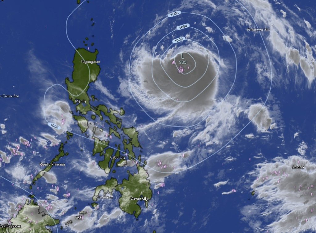
In its 5:00 p.m. weather bulletin on June 22, PAGASA reported that Typhoon Francisco was located approximately 1,070 kilometers east of Central Luzon as of 3:00 p.m., packing maximum sustained winds of 120 kilometers per hour near the center and gusts reaching up to 150 kilometers per hour. The typhoon was moving west-northwestward at 25 kilometers per hour.
Although the typhoon remains far from Mindanao, weather forecasters said its influence is enhancing the Southwest Monsoon, bringing unstable weather conditions across the island.
Rain Showers Expected Across Mindanao
PAGASA forecasts cloudy skies with rain showers and thunderstorms across most provinces in Mindanao from Tuesday morning until Wednesday morning.
Areas expected to experience persistent wet weather include the entire Zamboanga Peninsula, Northern Mindanao, Davao Region, SOCCSKSARGEN, Caraga Region, and the Bangsamoro Autonomous Region in Muslim Mindanao (BARMM).
Residents in the provinces of Zamboanga del Norte, Zamboanga del Sur, Zamboanga Sibugay, Bukidnon, Camiguin, Lanao del Norte, Misamis Occidental, Misamis Oriental, Davao de Oro, Davao del Norte, Davao del Sur, Davao Oriental, Davao Occidental, North Cotabato, South Cotabato, Sultan Kudarat, Sarangani, Agusan del Norte, Agusan del Sur, Surigao del Norte, Surigao del Sur, Dinagat Islands, Basilan, Sulu, Tawi-Tawi, Lanao del Sur, Maguindanao del Norte, and Maguindanao del Sur are advised to prepare for periods of moderate to occasionally heavy rainfall accompanied by thunderstorms.
Metro Davao and Cotabato City are likewise expected to experience similar weather conditions.
Risk of Flooding and Landslides
Weather authorities warned that thunderstorms may trigger sudden heavy downpours capable of causing flash floods in low-lying and flood-prone communities. Landslides are also possible in mountainous and landslide-prone areas, especially where soils remain saturated from previous rainfall.
PAGASA urged local disaster risk reduction offices and residents to closely monitor weather updates and advisories, particularly in areas vulnerable to flooding and slope failures.
Sea Conditions Remain Manageable
Across most coastal areas of Mindanao, sea conditions are expected to remain slight to moderate despite the influence of the Southwest Monsoon.
Winds will generally be light to moderate, blowing from the southwest to west. Fisherfolk operating small fishing vessels are still advised to exercise caution, particularly during thunderstorms that may generate sudden strong winds and rough seas.
Temperature Outlook
Temperatures across Mindanao are expected to remain relatively warm despite the rainy conditions.
Among the highest forecast temperatures are:
- Davao de Oro: up to 35°C
- Agusan del Norte: up to 34°C
- Surigao del Sur: up to 34°C
- Zamboanga City: up to 33°C
- Metro Davao: up to 33°C
- Agusan del Sur: up to 33°C
The coolest temperatures are expected in upland areas, particularly in Bukidnon and Lanao del Sur, where temperatures may drop to as low as 19°C and 20°C, respectively.
Public Advised to Stay Alert
While Typhoon Francisco remains outside the Philippine Area of Responsibility’s immediate threat zone for Mindanao, PAGASA emphasized that its indirect effects through the Southwest Monsoon can still bring significant rainfall across the island.
The public is encouraged to remain vigilant, monitor official weather bulletins, and take necessary precautions against flooding, lightning, and other hazards associated with thunderstorms as rainy conditions continue over the next 24 hours.