
DAVAO CITY, Philippines — While Tropical Storm “Maymay” (International name: Kujira) continues to move away from the country toward Northern Luzon, weather authorities are warning residents across Mindanao to remain vigilant as localized thunderstorms and the enhanced southwest monsoon continue to bring unstable weather conditions over the island.
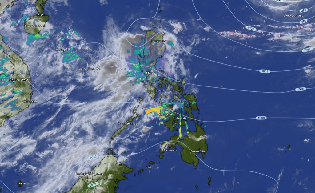
In its Regional Weather Forecast issued at 5:00 AM on August 6, 2026, the Philippine Atmospheric, Geophysical and Astronomical Services Administration (PAGASA) Mindanao Regional Services Division (MINPRSD) reported that the center of Tropical Storm Maymay was estimated at 155 kilometers west of Sinait, Ilocos Sur as of 3:00 PM Wednesday.
The storm was packing maximum sustained winds of 75 kilometers per hour, gustiness of up to 90 kilometers per hour, and was moving north-northeastward at 10 kilometers per hour.
Although the tropical cyclone is located far north of Mindanao, PAGASA said its influence, coupled with prevailing southwest winds, continues to create atmospheric instability that may trigger isolated rainshowers and severe thunderstorms across the island.
Thunderstorms May Trigger Flash Floods and Landslides
PAGASA forecasts partly cloudy to cloudy skies with isolated rainshowers and localized thunderstorms across the entire Mindanao region throughout the forecast period.
Residents, particularly those living in low-lying, flood-prone, mountainous, and landslide-prone communities, are advised to remain alert as severe thunderstorms may produce sudden heavy rainfall capable of causing flash floods and landslides.
Weather forecasters emphasized that although rainfall will not be continuous, localized thunderstorms may rapidly develop during the afternoon and evening, bringing intense downpours, lightning, and strong gusty winds.
Moderate to Rough Seas
The regional forecast also warns fishermen, small fishing vessels, and other sea travelers to exercise caution as moderate to strong southwesterly winds will prevail across Mindanao’s coastal waters.
Sea conditions are expected to range from moderate to rough, with wave heights reaching 1.2 to 2.8 meters, particularly along western and southern seaboards exposed to the southwest monsoon.
Mariners are encouraged to closely monitor weather bulletins before venturing into open waters.
Rainshowers Expected Across All Regions of Mindanao
PAGASA said similar weather conditions are expected across all five administrative regions in Mindanao.
In the Zamboanga Peninsula, including Zamboanga City, Isabela City, Zamboanga del Norte, Zamboanga del Sur, and Zamboanga Sibugay, residents can expect partly cloudy to cloudy skies with intermittent rainshowers and thunderstorms. Temperatures are forecast to range between 23°C and 35°C, while coastal waters will remain moderate to rough.
Across Northern Mindanao, including Bukidnon, Camiguin, Lanao del Norte, Misamis Occidental, and Misamis Oriental, isolated rainshowers and thunderstorms are likewise expected, with temperatures ranging from 21°C to 34°C.
The Davao Region, covering Metro Davao, Davao del Norte, Davao del Sur, Davao Oriental, Davao Occidental, and Davao de Oro, will also experience unstable weather conditions, with daytime temperatures ranging from 23°C to 35°C.
Residents in SOCCSKSARGEN, including North Cotabato, South Cotabato, Sultan Kudarat, and Sarangani, should also anticipate scattered thunderstorms with temperatures between 24°C and 34°C.
The same forecast extends to Caraga Region, where Agusan del Norte, Agusan del Sur, Surigao del Norte, Surigao del Sur, and Dinagat Islands are expected to experience intermittent rainshowers and thunderstorms with temperatures reaching up to 36°C in some areas.
Meanwhile, the Bangsamoro Autonomous Region in Muslim Mindanao (BARMM)—covering Cotabato City, Basilan, Lanao del Sur, Maguindanao del Norte, Maguindanao del Sur, Sulu, and Tawi-Tawi—will continue to experience partly cloudy to cloudy skies with occasional rainshowers and thunderstorms. Temperatures across the region are forecast between 21°C and 34°C.
Public Advised to Monitor Weather Updates
PAGASA reminds the public that localized thunderstorms can rapidly intensify, producing heavy rainfall over a short period despite generally fair weather earlier in the day.
Authorities advise residents to continue monitoring official weather advisories, especially those in flood- and landslide-prone areas, while local disaster risk reduction and management offices remain on alert for possible weather-related emergencies.
Although Tropical Storm Maymay is no longer directly threatening Mindanao, weather experts stress that its indirect effects, combined with the southwest monsoon, are sufficient to generate hazardous weather conditions across the island over the next 24 hours.