
DAVAO CITY — Most parts of Mindanao are expected to experience partly cloudy to cloudy skies with intermittent rainshowers and localized thunderstorms over the next 24 hours, according to the Philippine Atmospheric, Geophysical and Astronomical Services Administration (PAGASA).
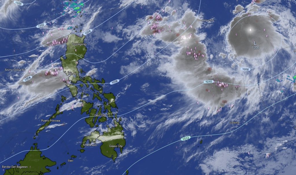
In its Regional Weather Forecast for Mindanao (MINPRSD) issued at 5:00 a.m. on September 4, 2026, PAGASA said the prevailing weather pattern could bring localized periods of heavy rain, particularly in areas affected by severe thunderstorms.
The weather agency warned that flash floods and landslides are possible in areas hit by severe thunderstorms, underscoring the need for residents in flood- and landslide-prone communities to remain alert, particularly during periods of intense rainfall.
The forecast is valid from 5:00 a.m. on September 4 until 5:00 a.m. on September 5, 2026.
Rain and thunderstorms across Mindanao
PAGASA’s forecast indicates that virtually all areas covered by the Mindanao regional forecast may experience rainshowers or thunderstorms during the forecast period.
In the Zamboanga Peninsula, Zamboanga City, Zamboanga del Norte, Zamboanga del Sur, Zamboanga Sibugay and Isabela City are forecast to have partly cloudy to at times cloudy skies, with possible rainshowers or thunderstorms.
Temperatures are expected to range from 24°C to 35°C, depending on the locality and period of the forecast.
Across Northern Mindanao, Bukidnon, Camiguin, Lanao del Norte, Misamis Occidental and Misamis Oriental are likewise expected to experience partly cloudy to cloudy conditions with rainshowers or thunderstorms.
Bukidnon is forecast to have the coolest temperatures in the region, with readings of about 21°C to 33°C.
Camiguin could see temperatures between 26°C and 35°C, while Lanao del Norte may reach 36°C during the warmer portion of the forecast period. Misamis Occidental and Misamis Oriental could also reach temperatures of 35°C to 36°C.
Davao Region to see moderate winds and seas
The Davao Region is also expected to remain under partly cloudy to cloudy skies with rainshowers or thunderstorms.
Metro Davao, Davao del Norte, Davao del Sur and Davao Oriental are forecast to experience moderate winds from the south to southwest, with coastal waters generally described as moderate.
Temperatures across the four areas are expected to range from 24°C to 34°C, with Davao del Norte forecast to reach around 32°C, Davao del Sur 33°C, Davao Oriental 34°C, and Metro Davao 33°C.
Davao de Oro is expected to experience temperatures between 23°C and 35°C, while Davao Occidental could record 23°C to 32°C.
The combination of moderate winds and moderate coastal conditions means those traveling or working at sea should continue monitoring local marine conditions, particularly during thunderstorms.
SOCCSKSARGEN also under thunderstorm watch
PAGASA likewise forecasts partly cloudy to cloudy skies with rainshowers or thunderstorms over North Cotabato, South Cotabato, Sultan Kudarat and Sarangani.
North Cotabato could experience temperatures of 23°C to 35°C, while South Cotabato is expected to range from 23°C to 33°C.
Sultan Kudarat may see temperatures between 23°C and 34°C, while Sarangani is forecast at around 25°C to 33°C.
Winds over most of the area are expected to be light to moderate from the south to southwest, although moderate winds and moderate seas are forecast over Sarangani.
Caraga may experience temperatures up to 36°C
The entire Caraga Region is also included in the thunderstorm forecast.
Agusan del Norte, Agusan del Sur, Surigao del Norte, Surigao del Sur and Dinagat Islands are expected to have partly cloudy to at times cloudy skies with rainshowers or thunderstorms.
Temperatures could climb as high as 36°C in Agusan del Norte, Surigao del Norte and Dinagat Islands during the warmer part of the forecast period.
Agusan del Sur may reach 35°C, while Surigao del Sur could see temperatures of up to 35°C.
Moderate winds from the south to southwest are forecast over Surigao del Norte, Surigao del Sur and Dinagat Islands, with their coastal waters expected to remain moderate.
BARMM provinces also face rain and thunderstorms
The weather forecast also covers several areas of the Bangsamoro Autonomous Region in Muslim Mindanao (BARMM).
Cotabato City, Basilan, Lanao del Sur, Sulu, Tawi-Tawi, Maguindanao del Norte and Maguindanao del Sur are all expected to experience partly cloudy to at times cloudy skies with rainshowers or thunderstorms.
Temperatures could range from 21°C to 35°C, with Lanao del Sur expected to record the lowest temperatures, at around 21°C to 30°C.
Sulu may reach 33°C, Tawi-Tawi 32°C, Basilan 35°C, Maguindanao del Norte 35°C, Maguindanao del Sur 35°C, and Cotabato City 34°C.
Winds in these areas are generally forecast to be light to moderate from the south to southwest, with slight to moderate coastal conditions.
Marine conditions
PAGASA said Mindanao’s coastal waters will generally range from slight to moderate, with wave heights of approximately 0.6 to 2.1 meters.
The Davao Region and several areas of Caraga and SOCCSKSARGEN are expected to experience moderate coastal conditions, while coastal waters elsewhere are generally forecast to be slight to moderate.
Fisherfolk, boat operators and other maritime users are advised to exercise caution when thunderstorms develop and to monitor succeeding weather advisories before venturing into open waters.
Residents urged to remain alert
While the regional forecast does not indicate continuous heavy rainfall across Mindanao, PAGASA’s warning on possible flash floods and landslides caused by severe thunderstorms highlights the localized nature of the threat.
Thunderstorms can develop rapidly and may produce intense rainfall over a short period, potentially causing sudden rises in rivers and creeks, flooding in low-lying communities and slope failures in vulnerable areas.
Residents living near waterways, steep slopes and other hazard-prone locations are urged to monitor local advisories and be prepared to move to safer areas if conditions deteriorate.
Motorists are likewise advised to exercise caution during heavy rain because sudden downpours can reduce visibility and create hazardous road conditions.
PAGASA’s MINPRSD forecast was prepared by forecasters ASS, KCC and KJCP.
For succeeding updates and weather information, the public is advised to monitor official PAGASA bulletins and advisories.