
GENERAL SANTOS CITY, Philippines — Cloudy skies, scattered rain showers, and thunderstorms are expected across Mindanao on Monday, October 12, as the Intertropical Convergence Zone (ITCZ) continues to affect the island, prompting warnings of possible flash floods and landslides in areas experiencing moderate to occasionally heavy rainfall.
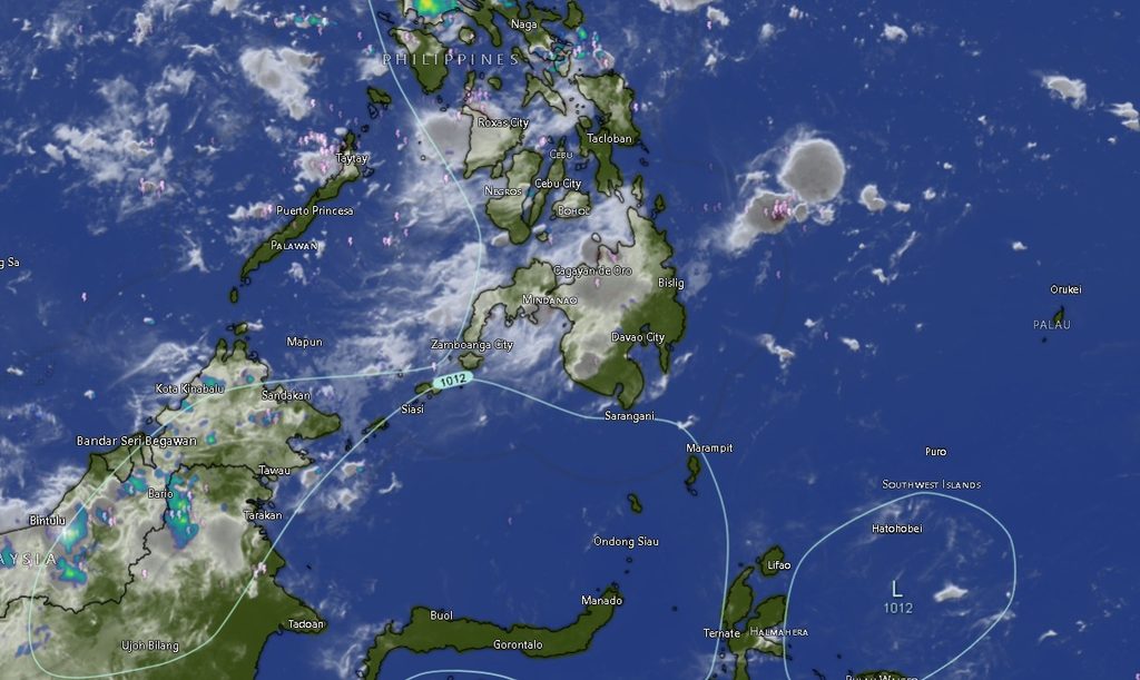
In its regional weather forecast issued at 5 a.m. on Monday, the Philippine Atmospheric, Geophysical and Astronomical Services Administration (PAGASA), through its Mindanao station (MINPRSD), said most areas in Mindanao would experience unsettled weather throughout the forecast period, which runs until 5 a.m. on Tuesday, October 13.
The weather bureau warned that periods of moderate to heavy rain could trigger flooding in low-lying and flood-prone communities, while landslides remain possible in mountainous areas and locations with unstable slopes.
Residents are advised to remain alert to changing weather conditions, particularly during thunderstorms and prolonged periods of rainfall. Local disaster risk reduction and management offices are also encouraged to monitor vulnerable communities and issue timely advisories when necessary.
Davao Region to Experience Rain and Thunderstorms
In Metro Davao, cloudy skies with rain showers and thunderstorms are forecast, with temperatures ranging from 25°C to 30°C during the initial forecast period. Temperatures could reach 32°C in the following period, while moderate southwesterly winds and moderate coastal conditions are expected.
Davao del Sur is forecast to experience cloudy skies with rain showers and thunderstorms, with temperatures ranging from 23°C to 29°C initially and reaching up to 31°C in the succeeding period. Moderate southwesterly winds and moderate sea conditions are also expected.
Davao Oriental will likewise experience cloudy skies with rain showers and thunderstorms, with temperatures ranging from 22°C to 29°C. Conditions may become partly cloudy at times, with rain showers or thunderstorms continuing into the following period. Temperatures could reach 30°C, accompanied by moderate southwesterly winds and moderate coastal conditions.
Davao del Norte is expected to have cloudy skies with rain showers and thunderstorms, with temperatures ranging from 24°C to 31°C during the initial period and reaching up to 33°C afterward. Winds are forecast to remain light to moderate from the southwest, with slight to moderate sea conditions.
Davao de Oro and Davao Occidental are also forecast to experience cloudy skies with rain showers and thunderstorms. Temperatures in Davao de Oro could reach 31°C, while Davao Occidental could experience temperatures of up to 32°C. Both provinces are expected to have moderate southwesterly winds and moderate coastal conditions.
Northern Mindanao Faces Continued Unsettled Weather
Across Northern Mindanao, cloudy skies with rain showers and thunderstorms are expected in Bukidnon, Camiguin, Lanao del Norte, Misamis Occidental, and Misamis Oriental.
Bukidnon is forecast to experience temperatures ranging from 20°C to 30°C during the initial period, potentially reaching 33°C in the succeeding period. Winds will generally be light to moderate from the south.
Camiguin is expected to have temperatures ranging from 27°C to 32°C initially, with highs of up to 34°C in the next forecast period. Light to moderate southerly winds and slight to moderate coastal conditions are forecast.
Lanao del Norte and Misamis Occidental will experience temperatures ranging from 24°C to 29°C initially, with highs of up to 31°C in the succeeding period. Misamis Oriental is forecast to have temperatures of 26°C to 30°C initially, with temperatures potentially reaching 32°C afterward.
Light to moderate southerly winds and slight to moderate sea conditions are expected in the coastal provinces of the region.
Zamboanga Peninsula to See Rain Showers and Thunderstorms
The provinces of Zamboanga del Norte, Zamboanga del Sur, and Zamboanga Sibugay, as well as Zamboanga City and Isabela City, are forecast to experience cloudy skies with rain showers and thunderstorms.
Zamboanga City and Zamboanga del Norte could register temperatures ranging from 25°C to 32°C during the initial forecast period, with highs of up to 34°C in the succeeding period.
Zamboanga del Sur is expected to experience cooler conditions, with temperatures ranging from 24°C to 30°C initially and reaching up to 31°C afterward.
Meanwhile, Zamboanga Sibugay and Isabela City are forecast to have temperatures ranging from 25°C to 30°C initially, with highs of up to 32°C in the following period.
Light to moderate southwesterly winds and slight to moderate coastal conditions are expected across the peninsula.
Caraga to Experience Rain, With Some Areas Becoming Partly Cloudy
Rain showers and thunderstorms are forecast across Agusan del Norte, Agusan del Sur, Surigao del Norte, Surigao del Sur, and Dinagat Islands.
Agusan del Norte is expected to experience temperatures ranging from 24°C to 32°C initially, with highs of up to 35°C in the succeeding period. Conditions may become partly cloudy at times, although rain showers or thunderstorms remain possible.
Agusan del Sur is forecast to have temperatures ranging from 24°C to 32°C initially, with highs of up to 34°C afterward.
Surigao del Norte and Surigao del Sur could experience temperatures reaching 34°C during the next forecast period, while Dinagat Islands is expected to have temperatures ranging from 26°C to 31°C initially, potentially reaching 33°C afterward.
Light to moderate southerly winds and slight to moderate sea conditions are forecast in coastal areas. Despite the possibility of partly cloudy skies in some locations, thunderstorms and periods of rain may still develop.
SOCCSKSARGEN to Remain Under Rain and Thunderstorm Conditions
North Cotabato, South Cotabato, Sultan Kudarat, and Sarangani are also expected to experience cloudy skies with rain showers and thunderstorms.
North Cotabato is forecast to have temperatures ranging from 23°C to 29°C during the initial period, with highs of up to 31°C in the succeeding period. Skies may become partly cloudy at times, although rain showers or thunderstorms remain possible.
South Cotabato and Sultan Kudarat are expected to experience temperatures ranging from 23°C to 30°C initially, with highs of up to 32°C afterward.
Sarangani is forecast to have temperatures ranging from 24°C to 29°C during the initial period, potentially reaching 31°C in the next period.
Winds across these provinces are expected to be light to moderate from the southwest. Coastal areas in South Cotabato, Sultan Kudarat, and Sarangani are forecast to experience slight to moderate sea conditions.
BARMM Areas Also Expected to Receive Rain
Across the Bangsamoro Autonomous Region in Muslim Mindanao (BARMM), cloudy skies with rain showers and thunderstorms are forecast in Cotabato City, Basilan, Lanao del Sur, Sulu, Tawi-Tawi, Maguindanao del Norte, and Maguindanao del Sur.
Cotabato City could experience temperatures ranging from 24°C to 31°C initially, with highs of up to 33°C in the succeeding period.
Basilan is forecast to have temperatures ranging from 24°C to 30°C initially, with temperatures reaching up to 32°C afterward. Conditions may become partly cloudy at times, but rain showers or thunderstorms remain possible.
Lanao del Sur is expected to experience temperatures ranging from 23°C to 29°C initially, with highs of up to 31°C in the following period.
Sulu and Tawi-Tawi are forecast to have temperatures reaching 33°C during the succeeding period, while Maguindanao del Norte and Maguindanao del Sur could experience highs of up to 34°C.
Light to moderate southwesterly winds and slight to moderate sea conditions are expected in coastal areas. Inland communities should also remain alert to localized flooding and other hazards associated with heavy rainfall.
Typhoon Koguma and Tropical Depression Remain Outside PAR
PAGASA’s regional bulletin also reported two tropical cyclones outside the Philippine Area of Responsibility (PAR), based on the information provided in its advisory.
Typhoon Koguma was located approximately 2,705 kilometers east-northeast of extreme Northern Luzon, at 25.4°N, 147.8°E. It had maximum sustained winds of 175 kilometers per hour near the center and gustiness of up to 215 kph, moving north-northwestward at 15 kph.
A separate tropical depression was located approximately 3,120 kilometers east of Central Luzon, at 16.0°N, 150.8°E. It had maximum sustained winds of 55 kph and gustiness of up to 70 kph, moving northeastward at 20 kph.
Both systems were reported outside PAR. The regional forecast attributes Mindanao’s expected rainy weather to the ITCZ.
The bulletin’s cyclone information should be read in the context of its stated reporting time, and residents should consult PAGASA’s latest official tropical cyclone advisories for subsequent updates.
Public Urged to Take Precautions Against Floods and Landslides
PAGASA said winds across Mindanao would generally be light to moderate, coming from the southwest to southeast, while coastal waters were forecast to range from slight to moderate, with wave heights of 0.6 to 1.8 meters under the general regional outlook. Some areas, particularly Metro Davao and parts of Davao Region, were forecast to experience moderate coastal conditions.
Even without a tropical cyclone directly affecting Mindanao, the ITCZ can bring persistent rainfall and thunderstorms capable of producing localized hazards.
Residents in flood-prone communities should monitor water levels and be prepared to move to safer locations if conditions deteriorate. People living near rivers, streams, steep slopes, and landslide-prone areas should watch for rapidly rising water, ground cracks, falling rocks, and other signs of danger.
Motorists are advised to exercise caution on slippery roads and in areas with poor visibility, while fishermen and other small-craft operators should check local marine advisories before venturing out to sea.
Local authorities and disaster response teams are encouraged to maintain close coordination with PAGASA and issue timely warnings when necessary.
The regional forecast is valid until 5 a.m. on Tuesday, October 13, 2026. Residents are urged to monitor official PAGASA bulletins and local government advisories for changes in weather conditions