
October 19, 2026 | The Mindanao Sentinel
The Intertropical Convergence Zone (ITCZ) is expected to bring cloudy skies, scattered rains, and thunderstorms to the Zamboanga Peninsula, Basilan, and Tawi-Tawi on Monday, October 19, while localized thunderstorms may affect the rest of Mindanao, according to the Philippine Atmospheric, Geophysical and Astronomical Services Administration (PAGASA).
In its regional weather forecast issued at 5 a.m. on October 19, PAGASA’s Mindanao station (MINPRSD) warned of possible flash floods and landslides in areas affected by moderate to occasionally heavy rainfall. Severe thunderstorms in other parts of Mindanao could also trigger flooding and landslides, particularly in vulnerable communities.
The forecast is valid from 5 a.m. on Monday until 5 a.m. on Tuesday, October 20.
ITCZ to bring rain to western Mindanao
PAGASA said the ITCZ is prevailing over the western section of Mindanao, bringing cloudy skies with rain showers and thunderstorms to Zamboanga City, Zamboanga del Norte, Zamboanga del Sur, Zamboanga Sibugay, Isabela City, Basilan, and Tawi-Tawi.
The weather system is a zone where winds converge, encouraging the development of clouds and precipitation. Depending on its location and intensity, it can produce widespread cloudiness, scattered rain, and thunderstorms that may bring periods of heavy rainfall.
The agency warned that moderate to occasionally heavy rains could trigger flash floods and landslides, particularly in low-lying communities, flood-prone areas, and locations near rivers and waterways.
Residents in landslide-prone communities should also remain alert to changing ground conditions, especially after prolonged or intense rainfall. Motorists are advised to exercise caution on roads where heavy rain may reduce visibility or cause flooding.
Localized thunderstorms expected across the rest of Mindanao
The rest of Mindanao is forecast to experience partly cloudy to cloudy skies, with isolated rain showers or thunderstorms caused by localized weather disturbances.
These conditions are expected across Northern Mindanao, the Davao Region, SOCCSKSARGEN, Caraga, and much of the Bangsamoro Autonomous Region in Muslim Mindanao (BARMM).
Although rainfall may be more localized in these areas, PAGASA cautioned that severe thunderstorms could still cause flash floods and landslides.
The possibility of intense, localized rainfall means communities should not assume they are safe from flooding simply because skies are partly cloudy or rain is intermittent. Thunderstorms can develop over specific locations and produce heavy downpours within a relatively short period.
Local disaster risk reduction and management offices are encouraged to monitor developing weather conditions and disseminate timely warnings, particularly in communities with a history of flooding and landslides.
Weather outlook for Zamboanga Peninsula, Basilan, and Tawi-Tawi
Zamboanga City is expected to experience cloudy skies with rain showers and thunderstorms, with temperatures ranging from 25 to 31 degrees Celsius. Zamboanga del Norte will have similar conditions, with temperatures between 26 and 32 degrees Celsius.
Zamboanga del Sur is forecast to record temperatures of 24 to 30 degrees Celsius, while Zamboanga Sibugay will experience temperatures ranging from 25 to 31 degrees Celsius. Isabela City is expected to have temperatures between 26 and 30 degrees Celsius.
Basilan is forecast to experience cloudy skies with rain showers and thunderstorms, with temperatures ranging from 24 to 29 degrees Celsius. Sulu is expected to have similar weather conditions, with temperatures between 26 and 31 degrees Celsius.
Tawi-Tawi, meanwhile, is forecast to experience partly cloudy to cloudy skies with rain showers or thunderstorms, with temperatures ranging from 26 to 31 degrees Celsius.
PAGASA warned that the ITCZ-related rainfall affecting these areas could trigger flash floods and landslides, especially where rainfall becomes moderate to heavy.
Northern Mindanao to experience isolated rain showers and thunderstorms
Bukidnon is forecast to have partly cloudy to cloudy skies with rain showers or thunderstorms, with temperatures ranging from 21 to 31 degrees Celsius. Camiguin will experience similar conditions, with temperatures between 26 and 32 degrees Celsius.
Lanao del Norte is expected to record temperatures of 22 to 28 degrees Celsius, while Misamis Occidental will have temperatures ranging from 24 to 29 degrees Celsius. Misamis Oriental is forecast to experience temperatures between 26 and 31 degrees Celsius.
Residents across Northern Mindanao should remain alert to possible severe thunderstorms, which may cause sudden flooding and landslides in susceptible locations.
Davao Region to experience partly cloudy skies and thunderstorms
Metro Davao is expected to experience partly cloudy to cloudy skies, with rain showers or thunderstorms and temperatures ranging from 25 to 31 degrees Celsius.
Davao del Norte is forecast to have temperatures between 24 and 31 degrees Celsius, while Davao del Sur will experience temperatures ranging from 23 to 31 degrees Celsius. Davao Oriental is expected to record temperatures of 22 to 30 degrees Celsius.
Davao de Oro is forecast to have temperatures between 22 and 30 degrees Celsius, while Davao Occidental will experience temperatures ranging from 24 to 30 degrees Celsius.
Although widespread rainfall is not indicated for the entire region, localized thunderstorms may still bring intense downpours. Residents in flood-prone urban areas and communities near rivers should remain cautious, particularly during periods of heavy rain.
SOCCSKSARGEN braces for possible thunderstorms
North Cotabato is forecast to experience partly cloudy to cloudy skies with rain showers or thunderstorms, with temperatures ranging from 23 to 31 degrees Celsius.
South Cotabato is expected to record temperatures of 24 to 31 degrees Celsius, while Sultan Kudarat will have temperatures between 23 and 30 degrees Celsius. Sarangani is forecast to experience temperatures ranging from 25 to 32 degrees Celsius.
Cotabato City is expected to have partly cloudy to cloudy skies, with rain showers or thunderstorms and temperatures between 24 and 31 degrees Celsius.
Maguindanao del Norte and Maguindanao del Sur are both forecast to experience similar weather conditions, with temperatures ranging from 24 to 32 degrees Celsius.
Residents should remain vigilant for severe thunderstorms that may trigger flash floods, especially in low-lying communities, areas with poor drainage, and locations near waterways.
Caraga to experience isolated rain showers and thunderstorms
Across Caraga, Agusan del Norte is forecast to have partly cloudy to cloudy skies with rain showers or thunderstorms, with temperatures ranging from 25 to 31 degrees Celsius.
Agusan del Sur will experience temperatures between 25 and 32 degrees Celsius, while Surigao del Norte is expected to record temperatures of 24 to 30 degrees Celsius.
Surigao del Sur is forecast to have temperatures ranging from 25 to 31 degrees Celsius, while the Dinagat Islands will experience temperatures between 27 and 32 degrees Celsius.
While partly cloudy conditions may prevail for much of the day, localized thunderstorms could still produce periods of heavy rainfall. Residents in communities exposed to flooding and landslides should monitor official advisories and be prepared for sudden changes in weather.
Super Typhoon Champi monitored outside PAR
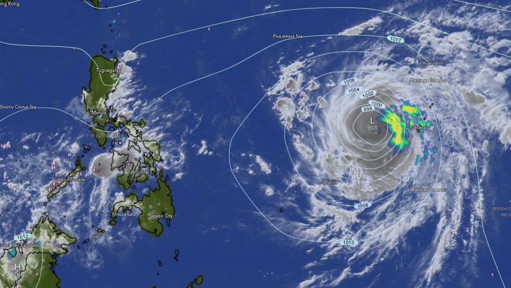
PAGASA’s regional forecast also reported Super Typhoon Champi, designated 2630, outside the Philippine Area of Responsibility (PAR).
As of 3 p.m. on Sunday, October 18, Champi was located approximately 2,000 kilometers east of southeastern Luzon, near latitude 13.1 degrees north and longitude 142.6 degrees east.
The tropical cyclone had maximum sustained winds of 185 kilometers per hour near its center, with gusts reaching 230 kph. It was moving westward at 20 kph.
These wind speeds indicate an extremely powerful tropical cyclone capable of producing destructive winds near its center. However, PAGASA identified the ITCZ and localized thunderstorms—not Champi—as the immediate weather systems responsible for the forecast conditions across Mindanao.
Champi’s reported location outside PAR should not be interpreted as confirmation of a direct threat to Mindanao. Its movement, intensity, and potential implications for the Philippines will depend on subsequent developments and updated official forecasts.
Residents are advised to monitor PAGASA’s succeeding tropical cyclone bulletins for any changes in the storm’s track or status.
Light to moderate winds and slight to moderate seas expected
PAGASA forecast light to moderate winds coming from the northwest to west across Mindanao, with coastal waters expected to remain slight to moderate and wave heights ranging from 0.6 to 1.5 meters.
Although these conditions are generally less hazardous than those associated with stronger winds and rough seas, fishermen, small boat operators, and other coastal communities should continue to assess local weather conditions before heading out to sea.
Sudden thunderstorms can bring strong gusts, reduced visibility, and rapidly changing conditions. Mariners should monitor official marine weather advisories and exercise caution, particularly when operating small vessels.
Public urged to prepare for flooding and landslides
The primary weather concern for Mindanao on Monday is the possibility of heavy rain and thunderstorms, particularly in areas affected by the ITCZ and locations where severe localized thunderstorms develop.
Residents in flood-prone communities should avoid crossing flooded roads and rivers, while those living near steep slopes should watch for signs of possible landslides. These include ground cracks, unusual water seepage, leaning trees, and sudden changes in the flow or color of water.
Households are encouraged to secure essential supplies, keep communication devices charged, and follow evacuation instructions issued by local authorities when conditions become dangerous.
PAGASA emphasized the potential for flash floods and landslides associated with the forecast weather systems. The public should continue monitoring official weather updates and advisories from local disaster risk reduction and management offices.
For further information, the public may visit PAGASA’s official website at https://bagong.pagasa.dost.gov.ph/ or contact its Mindanao station through the telephone numbers listed in the regional forecast: 8922-1992 and 8927-1335.
The Mindanao Sentinel reminder: Even when skies appear calm, residents should remain alert to sudden thunderstorms, localized flooding, and possible landslides throughout the forecast period.