
MINDANAO, Philippines — October 17, 2026 — Cloudy skies, scattered rain showers, and thunderstorms are expected across Mindanao throughout Saturday and into Sunday morning as the Intertropical Convergence Zone (ITCZ) continues to affect the island, according to the Philippine Atmospheric, Geophysical and Astronomical Services Administration (PAGASA).
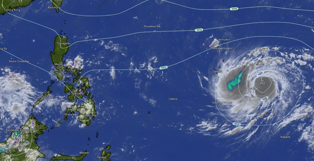
In its regional weather forecast issued at 5:00 a.m. on October 17, PAGASA warned that moderate to occasionally heavy rainfall could trigger flash floods and landslides, particularly in areas vulnerable to flooding, along waterways, and in communities near steep or unstable slopes.
The forecast is valid from 5:00 a.m. on Saturday until 5:00 a.m. on Sunday, October 18. Residents across Mindanao are advised to remain alert for rapidly changing weather conditions, especially during periods of intense rainfall and thunderstorms.
ITCZ to influence weather across Mindanao
The ITCZ, a zone where winds from different directions converge, is associated with rising air, cloud formation, and rainfall. Its continued influence is expected to bring widespread cloudy conditions and scattered precipitation across the island.
The forecast covers the Zamboanga Peninsula, Northern Mindanao, the Davao Region, SOCCSKSARGEN, Caraga, and the Bangsamoro Autonomous Region in Muslim Mindanao (BARMM).
Although the forecast generally indicates light winds, the possibility of moderate to occasionally heavy rain means that the risk of localized flooding and rain-induced landslides remains a significant concern.
Thunderstorms may also produce sudden downpours that can cause water levels in creeks and rivers to rise quickly. Communities in low-lying areas and locations with a history of flooding should monitor local conditions and follow advisories from authorities.
Zamboanga Peninsula: Rain showers and thunderstorms expected
Zamboanga City, Zamboanga del Norte, Zamboanga del Sur, Zamboanga Sibugay, and Isabela City are expected to experience cloudy skies with rain showers and thunderstorms.
Light winds from variable directions and slight coastal seas are forecast across the peninsula.
For Saturday, temperatures in Zamboanga City and Isabela City are expected to range from 25 to 32 degrees Celsius and 26 to 32 degrees Celsius, respectively. Zamboanga del Norte may experience temperatures of 26 to 32 degrees Celsius, while Zamboanga del Sur is forecast to have temperatures of 24 to 31 degrees Celsius. Zamboanga Sibugay is expected to record temperatures between 25 and 31 degrees Celsius.
Coastal waters are forecast to remain slight, with wave heights generally ranging from 0.6 to 1.2 meters under the regional outlook.
Northern Mindanao: Thunderstorms to affect five areas
Bukidnon, Camiguin, Lanao del Norte, Misamis Occidental, and Misamis Oriental are also expected to experience cloudy skies with rain showers and thunderstorms.
Bukidnon is forecast to have temperatures ranging from 21 to 30 degrees Celsius, making it among the cooler areas covered by the bulletin. Camiguin is expected to record temperatures between 26 and 30 degrees Celsius, while Lanao del Norte, Misamis Occidental, and Misamis Oriental may experience temperatures of 26 to 30 degrees Celsius.
Light winds are expected, with slight coastal seas in the coastal provinces.
Despite the generally light winds, residents in mountainous and upland communities should remain cautious during heavy rainfall because saturated soil and runoff may increase the risk of landslides and localized flooding.
Davao Region: Rain and thunderstorms across the region
Cloudy skies with rain showers and thunderstorms are forecast across Metro Davao, Davao del Norte, Davao del Sur, Davao de Oro, Davao Occidental, and Davao Oriental.
Metro Davao is expected to experience temperatures ranging from 26 to 31 degrees Celsius on Saturday. Davao del Norte may record 25 to 31 degrees Celsius, while Davao del Sur is forecast to have temperatures of 26 to 31 degrees Celsius.
Davao de Oro is expected to experience temperatures between 24 and 30 degrees Celsius, while Davao Occidental may record 25 to 29 degrees Celsius. Davao Oriental is forecast to have temperatures ranging from 25 to 32 degrees Celsius.
Light winds from variable directions and slight coastal seas are expected across the region under the provincial forecasts.
Residents should remain vigilant during thunderstorms, particularly in communities exposed to river overflow, flash flooding, and landslides. Motorists are also advised to exercise caution on roads where heavy rain could reduce visibility and make surfaces slippery.
SOCCSKSARGEN: Cloudy skies and thunderstorms expected
North Cotabato, South Cotabato, Sultan Kudarat, and Sarangani are expected to experience cloudy skies with rain showers and thunderstorms.
North Cotabato is forecast to have temperatures ranging from 25 to 32 degrees Celsius. South Cotabato and Sultan Kudarat may experience temperatures between 24 and 31 degrees Celsius, while Sarangani is expected to record temperatures of 26 to 30 degrees Celsius.
Light and variable winds are forecast, with slight coastal seas in coastal areas.
The possibility of moderate to occasionally heavy rainfall warrants particular attention in low-lying communities and areas near rivers and drainage channels. Residents should avoid crossing flooded roads and waterways, especially when water levels are rising or the depth and strength of the current cannot be determined.
Caraga: Rain showers expected across four provinces and Dinagat Islands
The Caraga Region is also expected to remain cloudy, with rain showers and thunderstorms affecting Agusan del Norte, Agusan del Sur, Surigao del Norte, Surigao del Sur, and the Dinagat Islands.
Agusan del Norte is forecast to experience temperatures ranging from 26 to 32 degrees Celsius, while Agusan del Sur may record 24 to 31 degrees Celsius. Surigao del Norte is expected to have temperatures between 26 and 31 degrees Celsius, Surigao del Sur between 25 and 31 degrees Celsius, and Dinagat Islands between 26 and 31 degrees Celsius.
Light winds and slight coastal seas are expected in the region’s coastal areas.
Given the rainfall outlook, residents in flood-prone communities and landslide-susceptible areas should monitor local advisories and prepare for possible disruptions to travel and daily activities.
BARMM: Rain and thunderstorms to affect provinces and island communities
Across BARMM, cloudy skies with rain showers and thunderstorms are forecast in Cotabato City, Basilan, Lanao del Sur, Sulu, Tawi-Tawi, Maguindanao del Norte, and Maguindanao del Sur.
Cotabato City is expected to experience temperatures ranging from 24 to 31 degrees Celsius. Basilan may record 26 to 32 degrees Celsius, while Lanao del Sur is forecast to have cooler conditions, with temperatures between 22 and 28 degrees Celsius.
Sulu is expected to experience temperatures ranging from 26 to 31 degrees Celsius, while Tawi-Tawi may record 27 to 31 degrees Celsius. Maguindanao del Norte is forecast to have temperatures between 24 and 31 degrees Celsius, and Maguindanao del Sur between 24 and 32 degrees Celsius.
Light winds from variable directions and slight coastal seas are expected across the areas covered by the provincial forecasts.
Communities in low-lying locations and areas vulnerable to flooding should take precautions during heavy rain. Residents in upland areas should also watch for signs of slope instability, including ground cracks, unusual water seepage, and small rockfalls.
Eastern Mindanao may experience stronger winds and higher waves
While light winds and slight seas are generally expected across much of Mindanao, PAGASA’s regional outlook indicates that the eastern sections of the island may experience light to moderate winds from the northeast to northwest.
Coastal waters in these eastern sections are forecast to range from slight to moderate, with wave heights of 0.6 to 1.5 meters. Elsewhere, winds are expected to remain light and variable, with slight seas of 0.6 to 1.2 meters.
The conditions may affect small fishing boats and other vessels operating in exposed coastal waters. Fisherfolk and boat operators should check local marine advisories and assess conditions before heading out to sea.
The provincial forecasts generally indicate slight seas, but the broader regional outlook specifically identifies the eastern sections of Mindanao as areas where waves could reach moderate conditions.
Public urged to take precautions against flooding and landslides
PAGASA’s principal warning for the forecast period is the possibility of flash floods and landslides caused by moderate to occasionally heavy rainfall.
Residents are advised to take the following precautions:
- Monitor official PAGASA weather updates and advisories from local government units and disaster risk reduction and management offices.
- Avoid crossing flooded roads, rivers, and streams, especially during periods of intense rainfall.
- Move away from steep slopes and areas with a history of landslides when conditions become dangerous, and follow evacuation instructions from authorities.
- Keep drainage channels clear where safe to do so, and prepare essential supplies in case flooding disrupts access to homes or communities.
- Exercise caution while driving during heavy rain because reduced visibility, slippery roads, and sudden flooding can increase accident risks.
- Fisherfolk and small-boat operators should check coastal conditions and follow instructions from the appropriate authorities before sailing.
The forecast does not establish that flooding or landslides will occur in every locality. However, the combination of widespread rain showers, thunderstorms, and the possibility of heavier downpours means that preparedness remains important throughout the validity period.
PAGASA’s Mindanao regional forecast was issued by the agency’s Mindanao–MINPRSD office in El Salvador City, Misamis Oriental. For additional information, the agency listed telephone numbers 8922-1992 and 8927-1335, as well as its official website, bagong.pagasa.dost.gov.ph.
Residents are encouraged to stay informed through official weather bulletins and local emergency advisories until conditions improve.