
GENERAL SANTOS CITY, Philippines — Cloudy skies, scattered rain showers and thunderstorms are expected across Mindanao from Friday morning, October 16, until Saturday morning, October 17, as the Intertropical Convergence Zone (ITCZ) continues to affect the island, according to the Philippine Atmospheric, Geophysical and Astronomical Services Administration (PAGASA).
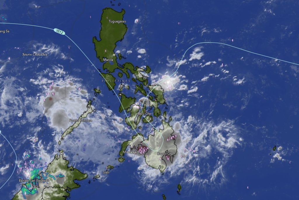
In its regional weather forecast for Mindanao issued at 5 a.m. on October 16, PAGASA warned that moderate to at times heavy rainfall could trigger flash floods and landslides, particularly in areas vulnerable to flooding, unstable slopes and rain-induced soil movement.
The forecast covers the Mindanao provinces and areas under the Mindanao regional weather forecasting service, including the Zamboanga Peninsula, Northern Mindanao, Davao Region, SOCCSKSARGEN, Caraga and the Bangsamoro Autonomous Region in Muslim Mindanao (BARMM).
PAGASA advised residents to remain alert for changing weather conditions, especially during thunderstorms and periods of intense rainfall.
ITCZ to bring unsettled weather across the island
The ITCZ, a region where winds converge and encourage the development of clouds and rain, is the prevailing weather system affecting Mindanao.
Under the forecast, cloudy skies with scattered rain showers and thunderstorms are expected across the island. Although rainfall may vary from one locality to another, the possibility of moderate to occasionally heavy downpours raises concerns about flooding in low-lying communities and landslides in mountainous and steep areas.
Communities near rivers, creeks and other waterways should remain attentive to sudden rises in water levels, particularly when heavy rain occurs upstream. Residents living near slopes or in areas with a history of landslides should also watch for signs of ground instability.
The forecast does not mean that every locality will experience continuous heavy rain throughout the day. However, thunderstorms may produce periods of intense rainfall that could create hazardous conditions even when rain is not persistent.
Davao Region: Rain and thunderstorms expected through Saturday
Metro Davao and the provinces of Davao del Norte, Davao del Sur, Davao de Oro, Davao Occidental and Davao Oriental are expected to experience cloudy skies with rain showers and thunderstorms.
For Metro Davao, temperatures are forecast to range from 26°C to 31°C during the initial forecast period, with the range extending to 26°C to 33°C in the succeeding period.
Davao del Norte and Davao del Sur are both expected to experience temperatures of 25°C to 31°C initially, increasing to forecast highs of 33°C in the succeeding period.
In Davao de Oro, temperatures are forecast at 25°C to 30°C, followed by 24°C to 32°C. Davao Occidental is expected to record temperatures of 25°C to 28°C initially and 24°C to 30°C afterward.
Davao Oriental is forecast to experience temperatures of 25°C to 31°C, followed by 24°C to 33°C.
Light to moderate winds from the northeast to northwest are expected across the Davao Region. Coastal waters are forecast to range from slight to moderate, with wave heights of 0.6 to 1.5 meters under the regional outlook.
While the forecast does not indicate a blanket warning against travel or maritime activities, residents and operators should continue monitoring local weather conditions, especially during thunderstorms and periods of stronger rainfall.
Caraga: Rainfall expected in all provinces
The Caraga Region is also expected to experience cloudy skies with rain showers and thunderstorms throughout the forecast period.
In Agusan del Norte, temperatures are forecast to range from 26°C to 32°C initially and 25°C to 34°C in the succeeding period. Agusan del Sur is expected to experience temperatures of 25°C to 30°C, followed by 24°C to 32°C.
Surigao del Norte is forecast to record temperatures of 26°C to 30°C initially and 26°C to 32°C afterward. Surigao del Sur is expected to have temperatures of 26°C to 31°C, followed by 25°C to 33°C.
The Dinagat Islands are forecast to experience temperatures of 27°C to 30°C during the initial period and 26°C to 32°C in the succeeding period.
Light to moderate winds from the northeast to northwest are expected across the region. Coastal waters in Agusan del Norte, Surigao del Norte, Surigao del Sur and the Dinagat Islands are forecast to range from slight to moderate.
Given the potential for moderate to occasionally heavy rainfall, residents in flood-prone communities and areas exposed to landslides should remain vigilant, particularly during thunderstorms.
Northern Mindanao: Thunderstorms expected from Bukidnon to Misamis Oriental
Cloudy skies with rain showers and thunderstorms are likewise forecast across Northern Mindanao, including Bukidnon, Camiguin, Lanao del Norte, Misamis Occidental and Misamis Oriental.
Bukidnon is expected to experience temperatures of 21°C to 29°C during the initial period, followed by 20°C to 31°C.
Camiguin, Lanao del Norte, Misamis Occidental and Misamis Oriental are forecast to experience temperatures generally ranging from 26°C to 29°C initially, followed by 25°C to 31°C.
Winds are expected to remain light to moderate, with slight coastal conditions forecast for the listed coastal areas.
Residents in upland communities and locations near steep slopes should pay particular attention to prolonged or intense rainfall. In Bukidnon and other areas with sloping terrain, heavy downpours may increase the risk of localized flooding and rain-induced landslides.
Zamboanga Peninsula: Cloudy skies and rain showers across the region
Zamboanga City, Zamboanga del Norte, Zamboanga del Sur, Zamboanga Sibugay and Isabela City are all expected to experience cloudy skies with rain showers and thunderstorms.
Zamboanga City and Isabela City are forecast to record temperatures of 25°C to 32°C during the initial period, with temperatures ranging from 24°C to 34°C in the succeeding period.
Zamboanga del Norte is expected to experience temperatures of 26°C to 32°C initially and 25°C to 34°C afterward. Zamboanga del Sur is forecast to record temperatures of 24°C to 30°C, followed by 23°C to 32°C.
Zamboanga Sibugay is expected to have temperatures of 25°C to 30°C initially and 24°C to 32°C in the succeeding period.
Light to moderate winds from varying directions are forecast, with slight coastal conditions across the listed areas.
Residents should remain alert for localized flooding, particularly in low-lying settlements and communities near waterways, if heavy rainfall develops.
SOCCSKSARGEN: Rain and thunderstorms expected in four provinces
North Cotabato, South Cotabato, Sultan Kudarat and Sarangani are also expected to experience cloudy skies with rain showers and thunderstorms.
North Cotabato is forecast to record temperatures of 25°C to 31°C initially and 24°C to 33°C afterward.
South Cotabato is expected to experience temperatures of 24°C to 31°C, followed by 23°C to 33°C. Sultan Kudarat is forecast to have temperatures of 26°C to 30°C initially and 25°C to 32°C in the succeeding period.
Sarangani is expected to experience temperatures of 26°C to 29°C initially and 26°C to 31°C afterward.
Light to moderate winds from varying directions are expected, with slight coastal conditions in the listed coastal areas.
Residents in communities near rivers, drainage channels and low-lying settlements should be prepared for possible localized flooding if rainfall becomes intense. Fisherfolk and other coastal workers should also monitor conditions before heading out to sea.
BARMM: Rain and thunderstorms to affect provinces and island communities
The ITCZ is also expected to bring cloudy skies, rain showers and thunderstorms to Cotabato City, Basilan, Lanao del Sur, Sulu, Tawi-Tawi, Maguindanao del Norte and Maguindanao del Sur.
Cotabato City is forecast to experience temperatures of 25°C to 31°C initially and 24°C to 33°C afterward.
Basilan is expected to record temperatures of 26°C to 32°C, followed by 25°C to 34°C. Lanao del Sur is forecast to have cooler conditions, with temperatures of 23°C to 27°C initially and 22°C to 29°C in the succeeding period.
Sulu is expected to experience temperatures of 25°C to 30°C initially and 24°C to 32°C afterward. Tawi-Tawi is forecast to record temperatures of 27°C to 31°C, followed by 26°C to 33°C.
Maguindanao del Norte is expected to experience temperatures of 25°C to 31°C initially and 24°C to 33°C in the succeeding period. Maguindanao del Sur is forecast to have temperatures of 24°C to 31°C, followed by 23°C to 33°C.
Winds are expected to remain light to moderate from varying directions, with slight coastal conditions forecast for the listed areas.
Residents in flood-prone communities should remain alert for sudden water-level increases and localized flooding. Communities near mountainous terrain should also exercise caution when moderate to heavy rain persists.
Coastal conditions: Slight to moderate seas
PAGASA’s regional outlook indicates that coastal waters along the eastern sections of Mindanao may experience light to moderate winds from the northeast to northwest, with wave heights of 0.6 to 1.5 meters.
The rest of Mindanao is expected to experience light winds from varying directions and generally slight seas, with wave heights of 0.6 to 1.2 meters.
Although these forecast wave heights indicate generally slight to moderate sea conditions, weather can change during thunderstorms. Fisherfolk, small boat operators and other people working at sea should check local conditions before departure and follow any advisories issued by authorities.
The forecast does not, by itself, establish a blanket suspension of maritime travel. Decisions should take into account updated bulletins, local warnings, vessel limitations and actual conditions at sea.
Residents urged to take precautions against flooding and landslides
With the ITCZ expected to maintain unsettled weather across Mindanao, precautionary measures remain important, especially in areas that are already vulnerable to flooding or slope failure.
Residents are advised to monitor official weather updates, keep drainage channels clear where safe to do so, avoid crossing flooded roads and waterways, and follow evacuation instructions issued by local disaster risk reduction and management offices.
People living near steep slopes should watch for warning signs such as new ground cracks, leaning trees or posts, unusual water seepage and small soil movements. If these signs appear, residents should move to a safer location and alert local authorities.
Motorists should exercise caution on rain-soaked roads, particularly where visibility is reduced or water accumulates. During thunderstorms, people should seek shelter in safe buildings and avoid exposed areas.
Local governments and emergency response teams are encouraged to remain prepared to respond to localized flooding, landslides and other rain-related incidents.
PAGASA’s Mindanao regional forecast was issued at 5 a.m. on October 16 and is valid until 5 a.m. on October 17, 2026. Residents should continue checking the agency’s official updates for changes in weather conditions.
For additional information, PAGASA lists the telephone numbers 8922-1992 and 8927-1335 and its official website, bagong.pagasa.dost.gov.ph.