
DAVAO CITY, Philippines — Much of Mindanao is expected to experience generally unsettled weather over the next 24 hours, with partly cloudy to cloudy skies, isolated rainshowers and localized thunderstorms forecast across the island, according to the Philippine Atmospheric, Geophysical and Astronomical Services Administration (PAGASA).
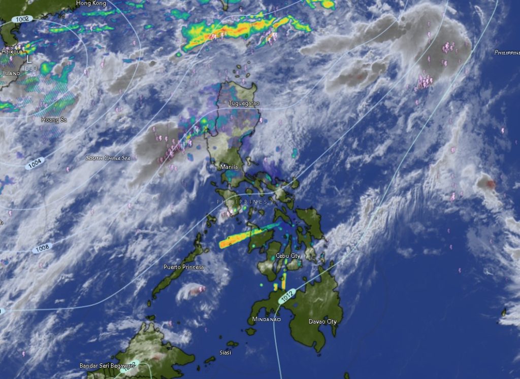
The regional weather forecast for Mindanao, issued by PAGASA’s Mindanao Regional Services Division (MINPRSD) at 5 a.m. on August 20, 2026, is valid from 5 a.m. Thursday until 5 a.m. Friday.
While widespread heavy rain is not being forecast across the entire region, PAGASA warned that severe thunderstorms could trigger flash floods and landslides, particularly in areas where intense rainfall occurs over a short period.
Residents in flood-prone communities, landslide-susceptible areas and locations near rivers and waterways were advised to remain alert to sudden changes in weather conditions, especially during periods of intense thunderstorms.
Thunderstorms possible across Mindanao
PAGASA said partly cloudy skies will prevail in most areas but may become cloudy at times as rainshowers or thunderstorms develop.
The same general weather pattern is expected across the Zamboanga Peninsula, Northern Mindanao, Davao Region, SOCCSKSARGEN, Caraga and parts of the Bangsamoro Autonomous Region in Muslim Mindanao (BARMM).
In the Zamboanga Peninsula, Zamboanga City, Zamboanga del Norte, Zamboanga del Sur, Zamboanga Sibugay and Isabela City are all forecast to experience partly cloudy to at times cloudy skies, with possible rainshowers or thunderstorms.
Temperatures in the area are expected to range from around 25°C to 32°C during the earlier forecast period, while daytime temperatures may reach 33°C to 35°C in some areas.
Across Northern Mindanao, Bukidnon is expected to remain relatively cooler, with temperatures ranging from 19°C to 28°C, while Camiguin, Lanao del Norte, Misamis Occidental and Misamis Oriental could experience temperatures reaching as high as 33°C to 35°C.
The Davao Region will likewise remain under the possibility of isolated rainshowers and thunderstorms. Metro Davao, Davao del Norte, Davao del Sur, Davao Oriental, Davao de Oro and Davao Occidental are all forecast to have partly cloudy to cloudy conditions at times.
Davao Oriental is expected to experience moderate southwest winds and moderate coastal conditions, while the rest of the Davao Region will generally have light to moderate winds from the south to southwest.
Temperatures across the region could climb to 35°C, with Davao del Norte and Davao de Oro among the areas forecast to experience relatively warmer daytime conditions.
SOCCSKSARGEN also under thunderstorm watch
In SOCCSKSARGEN, North Cotabato, South Cotabato, Sultan Kudarat and Sarangani are also expected to experience partly cloudy to cloudy skies with rainshowers or thunderstorms.
North Cotabato is forecast to have temperatures of about 24°C to 32°C, potentially reaching 34°C during the daytime.
South Cotabato will see temperatures ranging from approximately 23°C to 31°C, while Sultan Kudarat could reach 34°C.
Sarangani is expected to experience temperatures of around 25°C to 34°C, with coastal areas generally having slight to moderate sea conditions.
The forecast means communities across the region may experience rapidly changing weather, particularly when thunderstorms develop.
Caraga to experience moderate southwest winds
The entire Caraga Region is likewise expected to remain under partly cloudy to cloudy skies with possible rainshowers and thunderstorms.
Agusan del Norte, Agusan del Sur, Surigao del Norte, Surigao del Sur and the Dinagat Islands are forecast to experience moderate winds from the southwest.
Coastal waters in these areas are expected to remain moderate, with wave conditions generally within the range of 1.5 to 2.5 meters.
Daytime temperatures could reach 35°C to 36°C in several areas of Caraga, including Agusan del Norte, Agusan del Sur and the Dinagat Islands.
The combination of moderate winds and moderate seas could also affect small-craft operators, particularly in exposed coastal waters.
BARMM areas also face thunderstorms
The weather disturbance is not expected to spare areas of the Bangsamoro region.
Cotabato City, Basilan, Lanao del Sur, Sulu, Tawi-Tawi, Maguindanao del Norte and Maguindanao del Sur are all forecast to experience partly cloudy to at times cloudy skies, with isolated rainshowers or thunderstorms.
Temperatures in BARMM are expected to range from the low to mid-20s during cooler periods and could reach 36°C in some areas during the daytime.
Maguindanao del Norte and Maguindanao del Sur could experience temperatures as high as 36°C, while Tawi-Tawi may reach around 34°C.
Winds across these areas will generally be light to moderate from the south to southwest, with slight to moderate coastal conditions in areas where coastal forecasts apply.
Eastern Mindanao faces rougher seas
PAGASA said moderate winds from the southwest and moderate seas will prevail over the eastern section of Mindanao, with wave heights generally ranging from 1.5 to 2.5 meters.
The rest of Mindanao will experience light to moderate winds from the south to southwest, with slight to moderate seas measuring approximately 0.6 to 2.1 meters.
The sea conditions are particularly important for fishermen, passenger vessels and other small sea-going craft that may be operating along Mindanao’s extensive coastline.
Authorities and coastal communities are urged to closely monitor subsequent weather and marine advisories, especially when thunderstorms develop near coastal areas.
PAGASA warns of flash floods and landslides
The most significant concern in the latest forecast is the possibility of flash floods and landslides caused by severe thunderstorms.
Thunderstorms can produce intense rainfall within a short period, potentially overwhelming drainage systems and causing rapid rises in creeks, rivers and other waterways. In mountainous and steep-slope areas, intense rainfall can also destabilize soil and increase the risk of landslides.
Residents in vulnerable communities are therefore urged to avoid crossing swollen rivers and waterways and to remain alert for warnings from local disaster risk reduction and management offices.
Motorists should likewise exercise caution when traveling during heavy downpours because sudden flooding, poor visibility and slippery roads can create hazardous driving conditions.
People living near slopes, ravines and waterways should also remain vigilant for warning signs such as cracks in the ground, unusual water flows, falling rocks and sudden changes in river levels.
The forecast does not indicate that all areas of Mindanao will experience severe weather simultaneously. However, PAGASA’s warning underscores the potential for localized but intense thunderstorms, making continued monitoring important throughout the forecast period.
PAGASA’s MINPRSD reminded the public that weather conditions can change rapidly and advised communities to monitor official weather bulletins and warnings for the latest developments.