
MINDANAO – Residents across Mindanao should brace for another day of widespread rains, thunderstorms, and rough coastal conditions as the Southwest Monsoon (Habagat), enhanced by Typhoon “Inday” (international name: Bavi), continues to affect the island, according to the Philippine Atmospheric, Geophysical and Astronomical Services Administration (PAGASA).
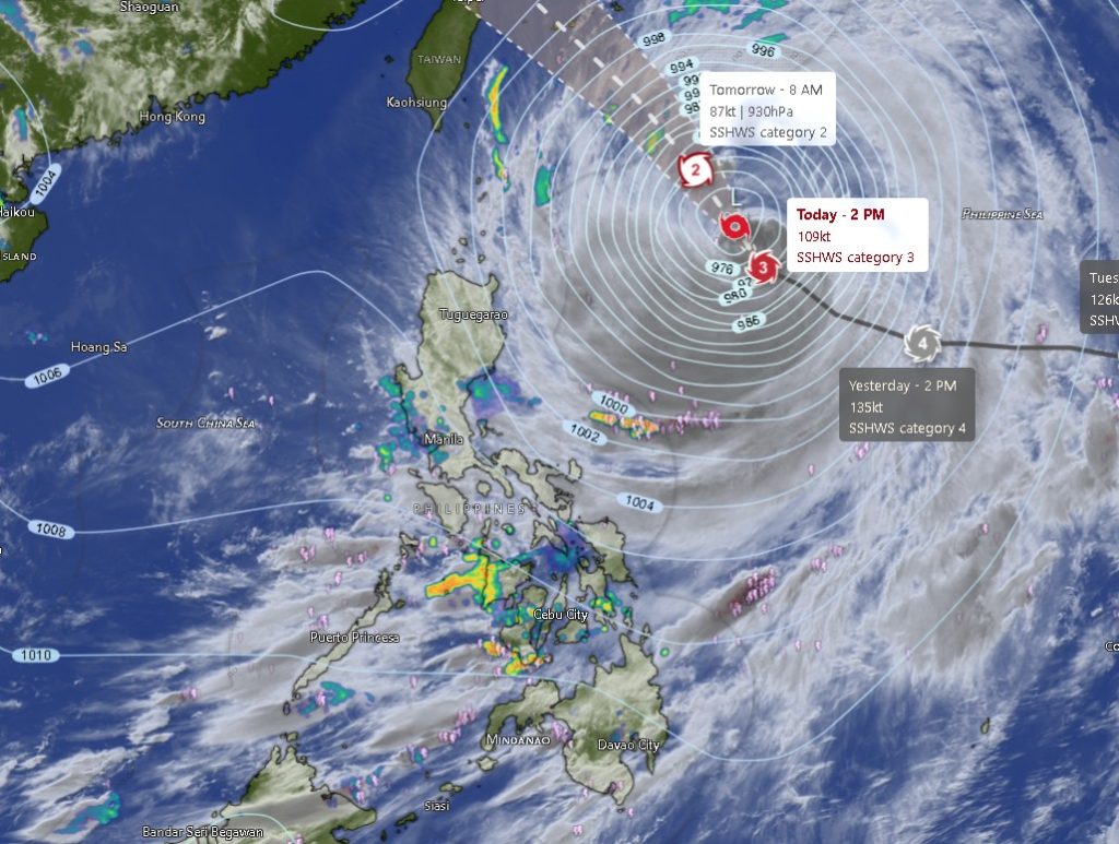
In its Regional Weather Forecast issued at 5:00 a.m. on Friday, July 10, 2026, PAGASA said Typhoon Inday remains over the Philippine Sea, with its center estimated at approximately 780 kilometers east of Aparri, Cagayan as of 3:00 p.m. Thursday.
The typhoon packs maximum sustained winds of 165 kilometers per hour, gusts reaching 205 kilometers per hour, and is moving west-northwestward at 20 kilometers per hour.
Although the cyclone remains far from Mindanao, it continues to enhance the Southwest Monsoon, bringing significant rainfall across the island.
Zamboanga Peninsula Under Persistent Rains
PAGASA forecasts occasional rains across the Zamboanga Peninsula, including Zamboanga City, Zamboanga del Sur, Zamboanga Sibugay, and Isabela City, while Zamboanga del Norte may initially experience partly cloudy skies with isolated rain showers before rainfall becomes more widespread.
Authorities warned that moderate to at times heavy rains could trigger flash floods and landslides, particularly in low-lying, flood-prone, and mountainous communities.
Temperatures across the peninsula are expected to range between 24°C and 30°C, accompanied by moderate to strong southwest winds and moderate to rough coastal waters.
Cloudy Skies and Thunderstorms Across the Rest of Mindanao
The rest of Mindanao—including Northern Mindanao, Davao Region, SOCCSKSARGEN, Caraga Region, and the Bangsamoro Autonomous Region in Muslim Mindanao (BARMM)—will experience cloudy skies with scattered rain showers and thunderstorms throughout the forecast period.
PAGASA warned that localized thunderstorms may produce moderate to heavy rainfall, increasing the risk of flooding and landslides, especially in areas already saturated by previous days’ rains.
The weather outlook covers:
- Northern Mindanao: Bukidnon, Camiguin, Lanao del Norte, Misamis Occidental, and Misamis Oriental.
- Davao Region: Davao City, Davao del Norte, Davao del Sur, Davao Oriental, Davao Occidental, and Davao de Oro.
- SOCCSKSARGEN: North Cotabato, South Cotabato, Sultan Kudarat, and Sarangani.
- Caraga Region: Agusan del Norte, Agusan del Sur, Surigao del Norte, Surigao del Sur, and Dinagat Islands.
- BARMM: Cotabato City, Basilan, Lanao del Sur, Sulu, Tawi-Tawi, Maguindanao del Norte, and Maguindanao del Sur.
Daytime temperatures across most provinces are forecast to range from 20°C to 33°C, depending on location.
Rough Seas Pose Risk to Small Vessels
PAGASA also warned of hazardous sea conditions along much of Mindanao’s coastline.
Northern and eastern sections of Mindanao are expected to experience moderate to strong west to southwest winds, producing moderate to rough seas with wave heights between 1.5 and 3.4 meters.
The rest of Mindanao will have light to moderate northwest to west winds with slight to moderate seas ranging from 0.6 to 1.5 meters.
Fisherfolk operating small boats, as well as operators of small sea vessels, are advised to exercise extreme caution or postpone voyages in areas affected by rough seas.
Public Advised to Stay Alert
Local disaster risk reduction and management offices continue to closely monitor weather developments as the Southwest Monsoon remains active.
Residents, particularly those living near rivers, creeks, coastal communities, and landslide-prone areas, are encouraged to remain vigilant for possible flooding and slope failures during periods of prolonged or intense rainfall.
Motorists are likewise advised to exercise caution while traveling, as reduced visibility and slippery road conditions may occur during heavy downpours.
PAGASA urged the public to continue monitoring official weather bulletins and advisories for the latest updates on Typhoon Inday and the prevailing Southwest Monsoon, as weather conditions may change rapidly over the next 24 hours.