June 26, 2026
The Philippine Atmospheric, Geophysical and Astronomical Services Administration (PAGASA) is closely monitoring two tropical cyclones outside the Philippine Area of Responsibility while warning residents across Mindanao to remain alert for localized thunderstorms that may trigger flash floods and landslides.
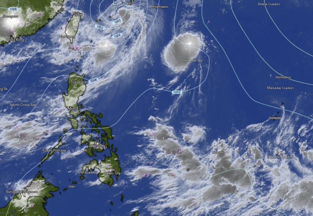
In its latest Regional Weather Forecast issued at 5:00 a.m. on Friday, June 26, PAGASA reported that Severe Tropical Storm Francisco (international name: Mekkhala) was located approximately 620 kilometers northeast of Itbayat, Batanes as of Thursday afternoon. The storm was packing maximum sustained winds of 95 kilometers per hour near the center and gustiness of up to 115 kilometers per hour.
Meanwhile, Tropical Storm Gardo (international name: Higos) was spotted 1,420 kilometers east of Extreme Northern Luzon, carrying maximum sustained winds of 85 kilometers per hour and gusts reaching 105 kilometers per hour. The weather disturbance was moving northwestward at a speed of 45 kilometers per hour.
Despite the presence of the two tropical cyclones, PAGASA said the Southwest Monsoon continues to affect Luzon and the Visayas, while localized thunderstorms remain the dominant weather system influencing conditions across Mindanao.
Rainshowers and Thunderstorms Expected Across Mindanao
Forecasters said the entire Mindanao island will experience partly cloudy to cloudy skies with isolated rainshowers and thunderstorms throughout the forecast period.
While widespread heavy rainfall is not expected, PAGASA warned that severe thunderstorms could still produce intense downpours capable of causing flash floods and landslides, particularly in low-lying, flood-prone, and mountainous areas.
Authorities advised residents to remain vigilant, especially during afternoon and evening thunderstorm activity when rainfall tends to intensify.
Light to Moderate Winds, Manageable Sea Conditions
Across Mindanao, winds are expected to remain light to moderate, blowing from the south to southwest. Coastal waters will generally be slight to moderate, with wave heights ranging from 0.6 to 1.8 meters.
The prevailing sea conditions are considered generally safe for small fishing vessels and other maritime activities, although fishermen and sea travelers are still encouraged to monitor weather advisories for sudden thunderstorm developments.
Zamboanga Peninsula
The provinces of Zamboanga del Norte, Zamboanga del Sur, Zamboanga Sibugay, Isabela City, and Zamboanga City are expected to experience intermittent rainshowers and thunderstorms amid partly cloudy to cloudy skies.
Temperatures across the region are forecast to range from 23°C to 35°C, with Zamboanga City likely recording the highest daytime temperatures.
Northern Mindanao
Bukidnon, Camiguin, Lanao del Norte, Misamis Occidental, and Misamis Oriental will continue to experience unstable weather conditions characterized by isolated rainshowers and thunderstorms.
Bukidnon is forecast to have the coolest temperatures in the region, ranging between 19°C and 33°C, while coastal provinces are expected to experience temperatures from 24°C to 33°C.
Davao Region
Metro Davao, Davao del Norte, Davao del Sur, Davao Oriental, Davao de Oro, and Davao Occidental will also see partly cloudy skies punctuated by occasional rainshowers and thunderstorms.
Temperatures in the region are expected to range from 23°C to 34°C. Davao de Oro may experience some of the warmest daytime temperatures, reaching up to 34°C.
SOCCSKSARGEN
North Cotabato, South Cotabato, Sultan Kudarat, and Sarangani are forecast to experience similar weather conditions with isolated thunderstorms developing throughout the day.
Temperatures across the region are expected to range from 22°C to 34°C, with South Cotabato and North Cotabato likely recording the highest daytime heat.
Caraga Region
Agusan del Norte, Agusan del Sur, Surigao del Norte, Surigao del Sur, and Dinagat Islands will continue to experience cloudy periods with scattered thunderstorm activity.
Daytime temperatures could reach as high as 35°C in parts of Agusan del Sur, Surigao del Norte, and Surigao del Sur, making them among the hottest areas in Mindanao during the forecast period.
BARMM Areas
The Bangsamoro Autonomous Region in Muslim Mindanao (BARMM), including Basilan, Sulu, Tawi-Tawi, Maguindanao del Norte, Maguindanao del Sur, Lanao del Sur, and Cotabato City, will likewise experience isolated rainshowers and thunderstorms.
Lanao del Sur is expected to remain one of the coolest areas in Mindanao, with temperatures ranging from 20°C to 30°C, while coastal provinces will generally record temperatures between 24°C and 32°C.
Public Advised to Stay Alert
PAGASA reminded the public that although no direct tropical cyclone threat currently exists over Mindanao, localized thunderstorms can rapidly develop and produce heavy rainfall, strong winds, and lightning.
Residents living near rivers, mountain slopes, and flood-prone communities are encouraged to monitor official weather bulletins and heed advisories from local disaster risk reduction and management offices.
The weather bureau continues to monitor the movement of Severe Tropical Storm Francisco and Tropical Storm Gardo as they traverse waters east and northeast of the country.