
DAVAO CITY, Philippines — Residents across Mindanao should prepare for possible rain showers and thunderstorms on Tuesday, October 27, as the Philippine Atmospheric, Geophysical and Astronomical Services Administration (PAGASA) forecast partly cloudy to cloudy skies across the island, with localized thunderstorms posing potential flooding and landslide risks.
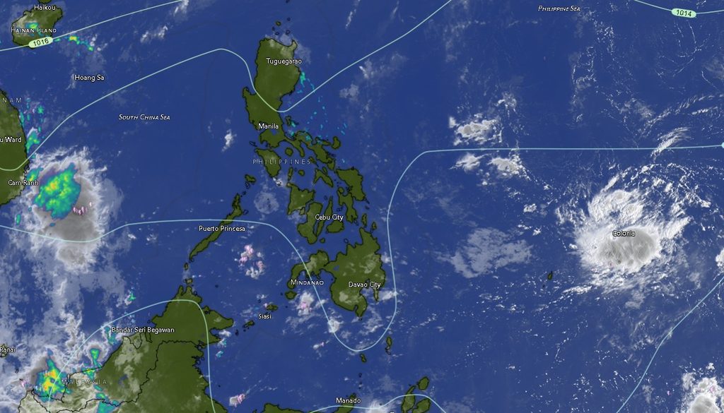
In its regional weather forecast issued at 5 a.m. on October 27, PAGASA said the forecast would remain valid until 5 a.m. on Wednesday, October 28. The weather agency warned that flash floods and landslides could occur during severe thunderstorms, particularly in areas vulnerable to sudden flooding and rain-induced slope failure.
The forecast covers communities across the Davao Region, Northern Mindanao, Zamboanga Peninsula, SOCCSKSARGEN, Caraga and the Bangsamoro Autonomous Region in Muslim Mindanao (BARMM). Although partly cloudy conditions may prevail at times, residents should not rule out sudden downpours and thunderstorms throughout the forecast period.
Davao Region faces possible afternoon and evening thunderstorms
Across Metro Davao, Davao del Norte, Davao del Sur, Davao Oriental, Davao de Oro and Davao Occidental, partly cloudy to cloudy skies with rain showers or thunderstorms are expected during both the daytime and nighttime periods.
Metro Davao is forecast to experience temperatures ranging from 25°C to 34°C during the day, cooling to between 25°C and 32°C at night. Davao del Norte may reach 34°C, while Davao del Sur is expected to record temperatures of 24°C to 33°C during the day.
Davao Oriental is forecast to have temperatures of 23°C to 31°C during the daytime, dropping to 23°C to 29°C at night. Davao de Oro is expected to experience similar nighttime temperatures, while Davao Occidental may record temperatures of 24°C to 32°C during the day and 24°C to 30°C at night.
The combination of warm daytime conditions and localized thunderstorms means residents should remain alert to rapidly changing weather, particularly when traveling or engaging in outdoor activities.
SOCCSKSARGEN and Cotabato areas also under rainy outlook
North Cotabato, South Cotabato, Sultan Kudarat and Sarangani are likewise expected to experience partly cloudy to cloudy skies with rain showers or thunderstorms throughout the forecast period.
North Cotabato is forecast to have temperatures ranging from 24°C to 33°C during the day and 24°C to 31°C at night. South Cotabato may experience temperatures of 23°C to 34°C, while Sultan Kudarat could reach 35°C during the daytime.
Sarangani is expected to record temperatures of 25°C to 34°C during the day, easing to 25°C to 32°C at night.
In Cotabato City, temperatures are forecast to range from 23°C to 33°C during the daytime and 23°C to 31°C at night. Maguindanao del Norte and Maguindanao del Sur may both experience daytime temperatures reaching 35°C before cooling to around 32°C at night.
PAGASA’s warning about possible flash floods and landslides during severe thunderstorms is particularly important for communities situated near waterways, flood-prone lowlands and steep or unstable terrain.
Northern Mindanao and Zamboanga Peninsula to experience similar conditions
The forecast also places Bukidnon, Camiguin, Lanao del Norte, Misamis Occidental and Misamis Oriental under partly cloudy to cloudy skies, with rain showers or thunderstorms possible during the day and evening.
Bukidnon is expected to have the coolest temperatures among the listed Northern Mindanao areas, ranging from 19°C to 33°C during the daytime and 19°C to 31°C at night.
Camiguin may experience temperatures of 25°C to 32°C during the day, while Misamis Occidental is forecast to record 23°C to 33°C. Misamis Oriental may reach 32°C, with nighttime temperatures dropping to around 30°C.
In the Zamboanga Peninsula, Zamboanga City, Zamboanga del Norte, Zamboanga del Sur, Zamboanga Sibugay and Isabela City are expected to experience the same general weather pattern. Daytime temperatures could reach 35°C in Zamboanga City and 34°C in Zamboanga del Norte, Zamboanga del Sur and Isabela City.
The agency also forecast light to moderate winds from the northeast across these areas.
Caraga, BARMM included in regional weather advisory
The Caraga provinces of Agusan del Norte, Agusan del Sur, Surigao del Norte, Surigao del Sur and the Dinagat Islands are also expected to experience partly cloudy to cloudy skies with rain showers or thunderstorms.
Surigao del Norte may record temperatures of 26°C to 31°C during the day, while the Dinagat Islands could reach 34°C. Agusan del Norte and Agusan del Sur may experience daytime temperatures reaching 34°C.
Across BARMM, including Basilan, Lanao del Sur, Sulu, Tawi-Tawi, Cotabato City, Maguindanao del Norte and Maguindanao del Sur, similar conditions are forecast.
Daytime temperatures in Lanao del Sur may range from 23°C to 31°C, while Tawi-Tawi could record temperatures of 26°C to 31°C. Sulu is expected to experience temperatures of 25°C to 33°C.
The regional forecast does not identify a single province as the exclusive focus of the weather disturbance. Instead, it describes a broad pattern of localized thunderstorms affecting various parts of Mindanao.
Coastal waters generally slight to moderate
PAGASA also forecast light to moderate winds from the northeast, with coastal waters generally slight to moderate at wave heights of 0.6 to 2.1 meters.
These conditions apply to the regional marine outlook, although actual sea conditions may vary by location and weather conditions may deteriorate during thunderstorms. Fisherfolk, boat operators and other maritime travelers should remain attentive to local conditions and any subsequent advisories.
Residents urged to take precautions
With thunderstorms possible across the island, residents are advised to monitor official weather updates and prepare for sudden changes in conditions.
People in flood-prone communities should watch for rising water levels and avoid crossing flooded roads or waterways. Those living near steep slopes, landslide-prone areas or locations with a history of rain-induced ground movement should remain alert during periods of heavy rainfall.
Motorists should exercise caution on wet roads and in areas where visibility may suddenly deteriorate. Outdoor workers and travelers should also be prepared to seek safe shelter when thunderstorms develop.
PAGASA emphasized that flash floods and landslides are possible during severe thunderstorms. The warning underscores the need for vigilance even when skies appear relatively clear between rain showers.
The forecast was issued by PAGASA’s Mindanao regional forecasting office, based in El Salvador City, Misamis Oriental. Residents may obtain additional weather information through the agency’s official website at bagong.pagasa.dost.gov.ph or its published regional contact numbers, 8922-1992 and 8927-1335.
The bottom line: Mindanao is expected to experience generally warm weather interrupted by localized rain showers and thunderstorms on Tuesday, with potential flash floods and landslides during severe weather. Residents are urged to stay informed, take necessary precautions and prioritize safety when conditions deteriorate.