
CAGAYAN DE ORO CITY, Philippines — October 23, 2026 — Several areas across Mindanao are expected to experience cloudy skies, scattered rain showers and thunderstorms on Friday as the trough of Typhoon Rosal (international name: Champi) affects parts of the island, prompting warnings of possible flash floods and landslides, according to the Philippine Atmospheric, Geophysical and Astronomical Services Administration (PAGASA).
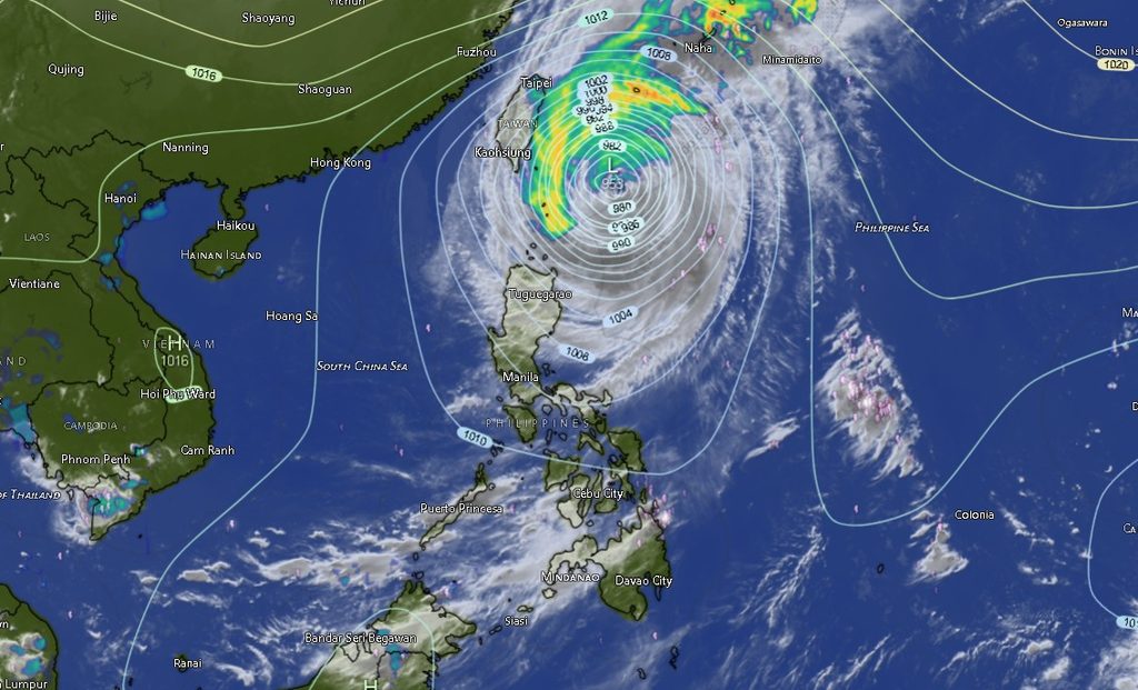
In its regional weather forecast issued at 5 a.m. on October 23, PAGASA’s Mindanao office said Zamboanga Peninsula, Lanao del Norte and Misamis Occidental would experience cloudy skies with scattered rains and thunderstorms due to the trough of the tropical cyclone.
Moderate to occasionally heavy rainfall in these areas could trigger flash floods and landslides, particularly in flood-prone communities, low-lying areas and locations near slopes vulnerable to erosion.
The rest of Mindanao is forecast to have partly cloudy to cloudy skies, with isolated rain showers or localized thunderstorms. PAGASA warned that severe thunderstorms could also cause flash floods and landslides in affected areas.
Although most provinces outside the western and northwestern portions of Mindanao are expected to experience generally fairer conditions between rain episodes, localized thunderstorms may still bring sudden downpours and rapidly changing weather.
Typhoon Rosal remains a powerful cyclone east of Batanes
PAGASA’s regional forecast identified Typhoon Rosal, internationally named Champi, as the weather system influencing Mindanao through its trough.
Based on the cyclone information included in the advisory, Rosal was located approximately 360 kilometers east of Itbayat, Batanes, at 3 p.m. on October 22, near 20.9 degrees north latitude and 125.3 degrees east longitude.
The typhoon had maximum sustained winds of 165 kilometers per hour near its center and gusts reaching 205 kph. It was moving northwestward at 15 kph.
The forecast did not indicate that the typhoon’s center was approaching Mindanao. Instead, its trough was identified as the cause of the expected scattered rains and thunderstorms over the Zamboanga Peninsula, Lanao del Norte and Misamis Occidental.
Residents should continue monitoring official bulletins for updates on the cyclone’s movement and any changes in local weather conditions.
Zamboanga Peninsula faces scattered rains and thunderstorms
Zamboanga City, Zamboanga del Norte, Zamboanga del Sur, Zamboanga Sibugay and Isabela City are expected to experience cloudy skies with rain showers and thunderstorms throughout the forecast period.
Temperatures across the area are forecast to range from the low 20s to the mid-30s Celsius, depending on the locality and time of day.
Zamboanga City and Isabela City are expected to record temperatures of 27°C to 33°C, while Zamboanga del Norte could experience 25°C to 34°C.
Zamboanga del Sur and Zamboanga Sibugay are forecast to have temperatures ranging from approximately 22°C to 32°C.
PAGASA warned that moderate to occasionally heavy rains could result in flash floods and landslides. Residents in vulnerable communities are advised to remain alert, especially during periods of intense or prolonged rainfall.
Northern Mindanao: Rain threat in Lanao del Norte and Misamis Occidental
Lanao del Norte and Misamis Occidental are also expected to experience cloudy skies with rain showers and thunderstorms associated with the typhoon’s trough.
Lanao del Norte could record temperatures of 23°C to 33°C, while Misamis Occidental is forecast to experience temperatures of 25°C to 34°C.
In contrast, Bukidnon, Camiguin and Misamis Oriental are expected to have partly cloudy to occasionally cloudy skies, with isolated rain showers or thunderstorms.
Bukidnon’s temperatures are forecast to range from 21°C to 29°C, while Camiguin could experience 26°C to 34°C. Misamis Oriental is expected to record temperatures of 25°C to 34°C.
Despite the comparatively less persistent rainfall forecast for these provinces, severe thunderstorms could still trigger localized flooding or landslides.
Davao Region: Isolated thunderstorms expected
Metro Davao, Davao del Norte, Davao del Sur, Davao de Oro, Davao Occidental and Davao Oriental are expected to experience partly cloudy to occasionally cloudy skies, with isolated rain showers or thunderstorms.
Temperatures in Metro Davao, Davao del Norte and Davao del Sur are forecast to range from 27°C to 33°C.
Davao de Oro could experience temperatures of 23°C to 33°C, while Davao Occidental is expected to record 27°C to 34°C.
Davao Oriental is forecast to have temperatures of 23°C to 33°C. However, coastal conditions in the province are expected to be more challenging than in several other parts of the region, with moderate to rough seas.
While the forecast does not call for widespread continuous rainfall across the Davao Region, thunderstorms may develop locally and produce sudden heavy downpours.
Residents should exercise caution in areas prone to flooding and landslides, particularly when thunderstorms intensify.
SOCCSKSARGEN: Warm conditions with localized rain
North Cotabato, South Cotabato, Sultan Kudarat and Sarangani are expected to experience partly cloudy to occasionally cloudy skies, with isolated rain showers or thunderstorms.
North Cotabato’s temperatures are forecast to range from 23°C to 31°C. South Cotabato and Sultan Kudarat could experience temperatures of 24°C to 31°C, while Sarangani is expected to record 24°C to 34°C.
The forecast indicates light to moderate winds from the northwest to southwest across the region.
Although no widespread continuous rainfall was forecast for SOCCSKSARGEN, thunderstorms could still bring intense rainfall to specific communities. Local authorities and residents should remain vigilant for possible flooding in low-lying areas and landslides in vulnerable upland communities.
Caraga: Thunderstorms possible across all provinces
Across Caraga, Agusan del Norte, Agusan del Sur, Surigao del Norte, Surigao del Sur and the Dinagat Islands are expected to experience partly cloudy to occasionally cloudy skies, with rain showers or thunderstorms.
Agusan del Norte could record temperatures of 25°C to 35°C, while Agusan del Sur is forecast to experience 23°C to 33°C.
Surigao del Norte is expected to have temperatures of 28°C to 35°C, with moderate winds from the northwest to southwest and moderate coastal conditions.
Surigao del Sur could experience temperatures of 23°C to 34°C, while the Dinagat Islands are forecast to record 25°C to 34°C, also with moderate winds and moderate coastal conditions.
The possibility of thunderstorms means that residents should be prepared for sudden rainfall, especially in communities vulnerable to flash floods and landslides.
Fisherfolk and other coastal workers in Surigao del Norte and the Dinagat Islands should pay particular attention to sea conditions before venturing offshore.
BARMM: Rain showers may intensify in several areas
The forecast for the Bangsamoro Autonomous Region in Muslim Mindanao (BARMM) indicates a transition from partly cloudy skies to cloudier conditions with rain showers and thunderstorms in several areas during Friday.
Cotabato City is expected to experience partly cloudy to occasionally cloudy skies with isolated rain showers or thunderstorms, with temperatures ranging from 24°C to 31°C.
Basilan, Lanao del Sur, Sulu, Tawi-Tawi, Maguindanao del Norte and Maguindanao del Sur are also expected to experience rain showers or thunderstorms, with cloudier conditions forecast in several of these areas during the later part of the forecast period.
Temperatures in Basilan could range from 27°C to 33°C, while Lanao del Sur is forecast to experience 22°C to 29°C.
Sulu and Tawi-Tawi are expected to record temperatures of 27°C to 33°C. Maguindanao del Norte and Maguindanao del Sur could experience temperatures of 25°C to 33°C.
Residents in BARMM should remain alert to localized thunderstorms and follow local advisories, particularly in communities susceptible to flooding.
Winds and coastal conditions
PAGASA forecast light to moderate winds from the northwest to southwest across Mindanao, with generally slight to moderate seas ranging from 0.6 to 2.5 meters.
However, the regional forecast specifically indicated moderate to rough seas along the coast of Davao Oriental, while moderate coastal conditions were expected in Surigao del Norte and the Dinagat Islands.
These conditions warrant caution among small fishing boats and other small vessels, particularly when thunderstorms develop or sea conditions deteriorate.
Fisherfolk and maritime operators should check the latest marine weather advisories and follow instructions from the Philippine Coast Guard and local authorities before sailing.
Residents urged to prepare for flooding and landslides
PAGASA’s forecast underscores the continuing risk posed by localized heavy rainfall, even in areas where widespread rain is not expected.
Flash floods can develop quickly when intense rain falls over a short period, while prolonged rainfall can weaken slopes and increase the risk of landslides, especially in mountainous and previously saturated areas.
Residents are advised to monitor official weather updates, avoid crossing flooded roads and waterways, and stay away from unstable slopes during periods of heavy rain.
People living in flood-prone communities should prepare essential supplies and follow evacuation instructions from local disaster risk reduction and management offices when necessary.
Motorists should also exercise caution on slippery roads and in areas where poor visibility or water accumulation may make travel hazardous.
The regional forecast was issued by PAGASA’s Mindanao office in El Salvador City, Misamis Oriental, at 5 a.m. on October 23, 2026, and is valid until 5 a.m. on October 24.
For updated weather information, the public may visit PAGASA’s official website at bagong.pagasa.dost.gov.ph or contact the agency through its published information channels.