
CAGAYAN DE ORO CITY, Philippines — The Philippine Atmospheric, Geophysical and Astronomical Services Administration (PAGASA) has warned of scattered rains and thunderstorms across several areas of Mindanao on Saturday, October 24, as the Intertropical Convergence Zone (ITCZ) affects the Zamboanga Peninsula, parts of Northern Mindanao, portions of Caraga, and island provinces in the Bangsamoro Autonomous Region in Muslim Mindanao (BARMM).
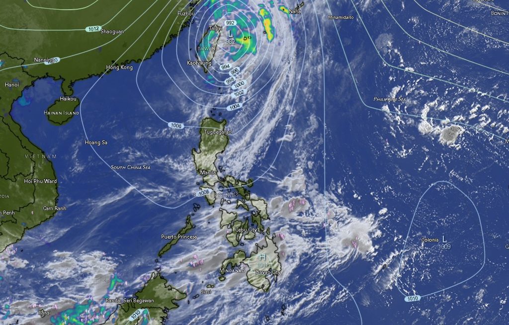
In its regional weather forecast issued at 5 a.m. on October 24, PAGASA said Zamboanga Peninsula, Northern Mindanao, Agusan del Norte, Surigao del Norte, Dinagat Islands, Basilan, and Tawi-Tawi will experience cloudy skies with scattered rains and thunderstorms throughout the forecast period, which runs until 5 a.m. on Sunday, October 25.
The weather bureau warned that moderate to, at times, heavy rainfall in these areas could trigger flash floods or landslides, particularly in communities vulnerable to flooding, areas near rivers and waterways, and locations with unstable slopes.
Meanwhile, the rest of Mindanao will have partly cloudy to cloudy skies with isolated rain showers or localized thunderstorms. PAGASA cautioned that severe thunderstorms could still cause flash floods or landslides, even in areas where rainfall is not widespread.
Zamboanga Peninsula, Northern Mindanao face sustained rainfall
The Zamboanga Peninsula is expected to experience cloudy conditions with rain showers and thunderstorms in Zamboanga City, Zamboanga del Norte, Zamboanga del Sur, Zamboanga Sibugay, and Isabela City.
Daytime temperatures in the region are forecast to range from 25 to 34 degrees Celsius, while nighttime and early-morning temperatures are expected to fall to between 24 and 32 degrees Celsius, depending on the locality.
In Northern Mindanao, Bukidnon, Camiguin, Lanao del Norte, Misamis Occidental, and Misamis Oriental are also expected to experience cloudy skies with rain showers and thunderstorms.
Temperatures in Bukidnon will range from 21 to 31 degrees Celsius during the day, while coastal and lowland areas will generally experience temperatures reaching 30 to 34 degrees Celsius.
The persistence of rain-producing weather systems in these areas raises the risk of localized flooding, especially during periods of heavier downpours. Residents in flood-prone communities are advised to monitor changing weather conditions and follow warnings issued by local disaster risk reduction and management offices.
Davao Region, SOCCSKSARGEN may experience localized thunderstorms
Unlike areas directly affected by the ITCZ, Davao Region and SOCCSKSARGEN are forecast to experience partly cloudy to cloudy skies, with isolated rain showers or localized thunderstorms.
The forecast covers Metro Davao and the provinces of Davao del Norte, Davao del Sur, Davao Oriental, Davao de Oro, and Davao Occidental.
Temperatures across Davao Region are expected to range from 23 to 34 degrees Celsius, with Sarangani and Davao del Norte among the areas that could reach 34 degrees Celsius. Sarangani may experience the highest daytime temperature in the region, reaching up to 35 degrees Celsius according to the forecast for SOCCSKSARGEN.
North Cotabato, South Cotabato, Sultan Kudarat, and Sarangani are likewise expected to have partly cloudy to cloudy skies with rain showers or thunderstorms.
Although widespread rainfall is not forecast for these areas, localized thunderstorms could produce sudden heavy rain. PAGASA warned that severe thunderstorms may trigger flash floods or landslides, underscoring the need for caution even in communities that experience generally fair weather for much of the day.
Residents should remain alert to rapidly developing thunderstorms, particularly during outdoor activities, travel, and work in agricultural areas.
Caraga faces rain and coastal hazards
In the Caraga Region, Agusan del Norte, Surigao del Norte, and Dinagat Islands are expected to experience cloudy skies with rain showers and thunderstorms due to the ITCZ.
Agusan del Sur and Surigao del Sur, meanwhile, are forecast to have partly cloudy to cloudy skies with isolated rain showers or thunderstorms.
Daytime temperatures across the region are expected to range from 25 to 34 degrees Celsius. Surigao del Norte and Dinagat Islands may experience moderate coastal conditions, while Surigao del Sur is forecast to have moderate to rough seas.
The forecast indicates that coastal conditions may vary considerably across Caraga, making it important for fishers, boat operators, and other coastal communities to pay attention to local sea conditions before venturing offshore.
BARMM provinces also expect rain and thunderstorms
Several island provinces in BARMM, including Basilan, Sulu, and Tawi-Tawi, are expected to experience cloudy skies with rain showers and thunderstorms associated with the ITCZ.
Basilan is forecast to have temperatures ranging from 24 to 32 degrees Celsius, while Sulu may experience temperatures reaching 34 degrees Celsius during the day. Tawi-Tawi is expected to have daytime temperatures of 27 to 33 degrees Celsius.
Cotabato City, Lanao del Sur, Maguindanao del Norte, and Maguindanao del Sur, on the other hand, are expected to experience partly cloudy to cloudy skies with isolated rain showers or thunderstorms.
Maguindanao del Sur may record temperatures reaching 35 degrees Celsius, making it one of the warmest areas covered by the regional forecast.
Despite the warmer conditions in some mainland areas, localized thunderstorms may still develop and bring sudden downpours.
South to southwest winds; seas may reach 2.5 meters
PAGASA said light to moderate winds from the south to southwest will prevail over Mindanao, with slight to moderate seas generally ranging from 0.6 to 2.5 meters.
However, the forecast identifies areas with more challenging coastal conditions. Surigao del Norte and Dinagat Islands are expected to have moderate seas, while Surigao del Sur may experience moderate to rough seas.
Fishers and operators of small seacraft should take local sea conditions into account before sailing, particularly in areas where waves may be higher. Coastal residents and travelers using sea transport should also monitor advisories from the relevant authorities.
Residents urged to take precautions
With the ITCZ bringing sustained rain to several parts of Mindanao, residents are advised to remain vigilant for possible flooding and landslides, particularly in low-lying communities, near rivers, and in mountainous or landslide-prone areas.
Local authorities and disaster response teams should continue monitoring rainfall and water levels, especially where heavy downpours may affect communities with a history of flooding.
Residents should avoid crossing flooded roads and rivers, watch for signs of slope instability, and follow evacuation instructions if issued by local officials. Those planning outdoor activities should also be prepared for sudden thunderstorms, even in areas where the forecast calls for only isolated rain showers.
PAGASA’s forecast covers the period from 5 a.m. on Saturday, October 24, until 5 a.m. on Sunday, October 25. Weather conditions may change, and residents are encouraged to monitor official updates for localized warnings and further advisories.
Source: Philippine Atmospheric, Geophysical and Astronomical Services Administration (PAGASA), Mindanao Regional Weather Forecast, issued at 5 a.m., October 24, 2026.