
MINDANAO, Philippines — Residents across Mindanao are advised to remain vigilant against possible flash floods and landslides as localized thunderstorms are expected to affect the region through Wednesday, October 21, according to the Philippine Atmospheric, Geophysical and Astronomical Services Administration (PAGASA).
In its regional weather forecast issued at 5 a.m. on Wednesday, PAGASA said Mindanao would experience partly cloudy to cloudy skies, with isolated rain showers or localized thunderstorms throughout the forecast period, which runs until 5 a.m. on Thursday, October 22.
Although widespread rainfall is not necessarily expected across the entire region, PAGASA warned that severe thunderstorms could trigger flash floods and landslides, particularly in areas vulnerable to flooding and those with unstable slopes.
Residents in low-lying communities, flood-prone neighborhoods and mountainous areas are encouraged to monitor changing weather conditions and follow advisories from local government units and disaster risk reduction and management offices.
Thunderstorms expected across Mindanao
The forecast covers the Zamboanga Peninsula, Northern Mindanao, the Davao Region, SOCCSKSARGEN, Caraga and the Bangsamoro Autonomous Region in Muslim Mindanao (BARMM).
In the Zamboanga Peninsula, Zamboanga City and the provinces of Zamboanga del Norte, Zamboanga del Sur and Zamboanga Sibugay, as well as Isabela City, are expected to experience partly cloudy to cloudy skies with intermittent rain showers or thunderstorms. Temperatures in these areas are forecast to range from the mid-20s to the mid-30s Celsius during the forecast period.
Across Northern Mindanao, Bukidnon, Camiguin, Lanao del Norte, Misamis Occidental and Misamis Oriental may also experience similar weather conditions. Bukidnon is expected to have relatively cooler temperatures, ranging from 21°C to 29°C, while other areas may reach temperatures of around 30°C to 34°C.
In the Davao Region, Metro Davao and the provinces of Davao del Norte, Davao del Sur, Davao Oriental, Davao de Oro and Davao Occidental are forecast to experience intermittent rain showers or thunderstorms. Temperatures could reach 35°C in Davao Oriental and Davao de Oro, while Davao Occidental is expected to have comparatively cooler conditions, with temperatures ranging from 24°C to 31°C.
The SOCCSKSARGEN region, including North Cotabato, South Cotabato, Sultan Kudarat and Sarangani, is likewise expected to experience partly cloudy to cloudy skies with isolated rain showers or thunderstorms. Temperatures in these areas may reach 33°C, while Sarangani is forecast to have temperatures ranging from 26°C to 31°C.
In Caraga, Agusan del Norte, Agusan del Sur, Surigao del Norte, Surigao del Sur and the Dinagat Islands are expected to experience similar weather conditions. Temperatures in the region could climb to 35°C, particularly in Surigao del Sur.
The same general weather pattern is forecast across BARMM, including Cotabato City, Basilan, Lanao del Sur, Sulu, Tawi-Tawi, Maguindanao del Norte and Maguindanao del Sur. Temperatures in these areas may reach 35°C, even as localized thunderstorms remain possible.
Light to moderate winds, slight to moderate seas
PAGASA said light to moderate winds from the northwest to southwest would prevail across Mindanao during the forecast period.
Coastal waters are expected to remain slight to moderate, with wave heights ranging from 0.6 to 2.5 meters.
Despite the generally manageable sea conditions indicated in the forecast, fishermen, boat operators and other coastal residents are advised to remain alert to sudden changes in weather, particularly when thunderstorms develop.
Those planning sea travel should continue to monitor local marine advisories and follow safety instructions from authorities, as weather conditions may change during localized thunderstorms.
Super Typhoon Rosal remains outside PAR
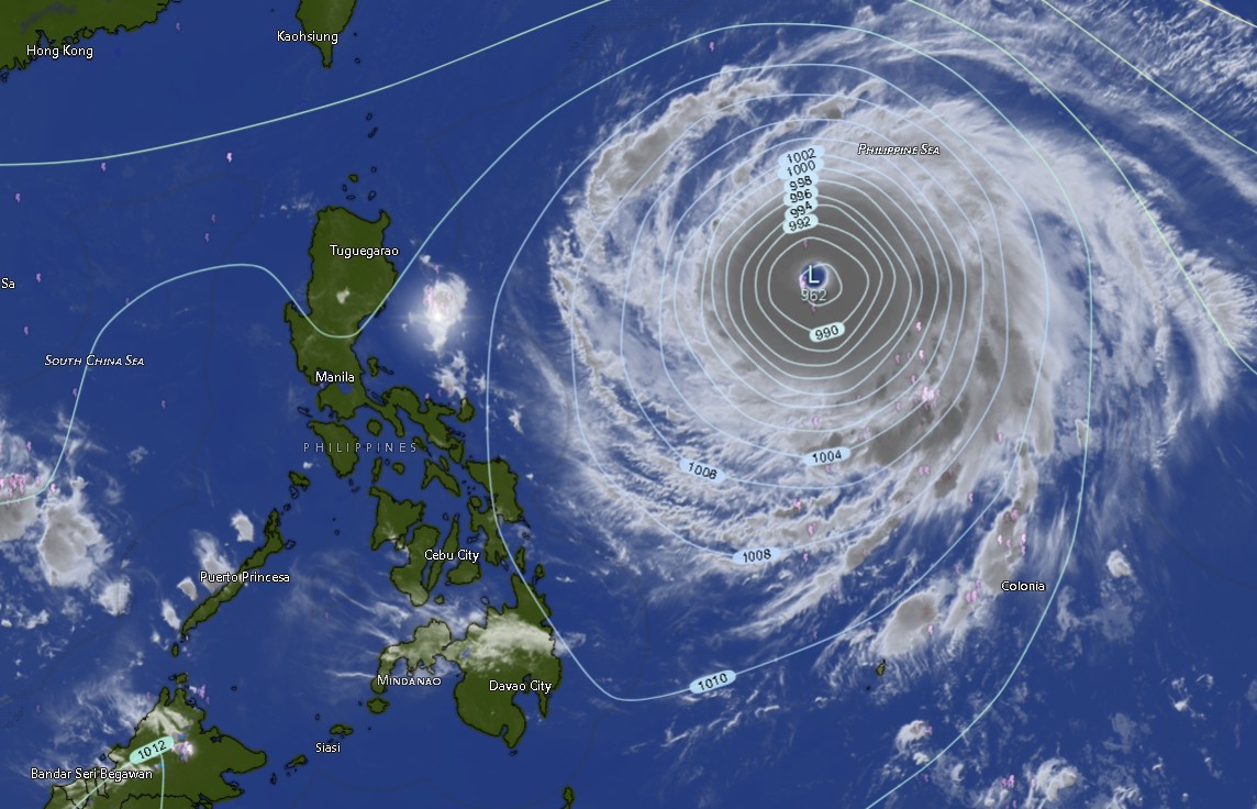
PAGASA’s regional bulletin also reported Super Typhoon Rosal, internationally named Champi, outside the Philippine Area of Responsibility (PAR).
Based on the tropical cyclone information included in the bulletin, the super typhoon was located approximately 1,290 kilometers east of Central Luzon, near 16.5 degrees north latitude and 134.2 degrees east longitude.
The system had maximum sustained winds of 195 kilometers per hour near its center and gusts reaching 240 kph. It was moving west-northwestward at 25 kph.
However, the bulletin’s forecast for Mindanao continued to identify localized thunderstorms as the prevailing weather concern. The available information does not establish that Super Typhoon Rosal is directly causing the thunderstorms expected across Mindanao.
Residents are therefore advised to distinguish between the regional weather outlook and the tropical cyclone’s position and movement, while continuing to monitor official PAGASA updates for any changes in the system’s track or potential effects on the country.
Public urged to take precautions
With thunderstorms expected across several parts of Mindanao, residents are encouraged to take precautions against sudden flooding and other weather-related hazards.
People in flood-prone communities should watch for rapidly rising water levels and follow evacuation instructions when issued. Those living near slopes and areas susceptible to landslides should remain alert to signs of ground instability, particularly during or after periods of heavy rainfall.
Motorists should exercise caution on wet roads and in areas where visibility may be reduced by rain. Outdoor activities should also be adjusted when thunderstorms develop, especially in exposed areas.
Local authorities and emergency responders are encouraged to remain prepared for weather-related incidents, particularly in communities with a history of flooding or landslides.
PAGASA’s Mindanao regional weather forecast was issued by its Mindanao office in El Salvador City, Misamis Oriental. The agency advised the public to consult its official website, bagong.pagasa.dost.gov.ph, or contact its published telephone hotlines at 8922-1992 and 8927-1335 for further information.
As localized thunderstorms continue to affect Mindanao, the public is reminded that periods of partly cloudy skies do not rule out sudden, intense rainfall in individual communities. Staying informed and responding promptly to official warnings remain essential to reducing risks to lives and property.