
CAGAYAN DE ORO CITY, Philippines — Large parts of Mindanao are expected to experience cloudy skies, scattered rain showers and thunderstorms as the Intertropical Convergence Zone (ITCZ) continues to influence weather conditions across the island, according to the latest regional weather forecast from the Philippine Atmospheric, Geophysical and Astronomical Services Administration (PAGASA).
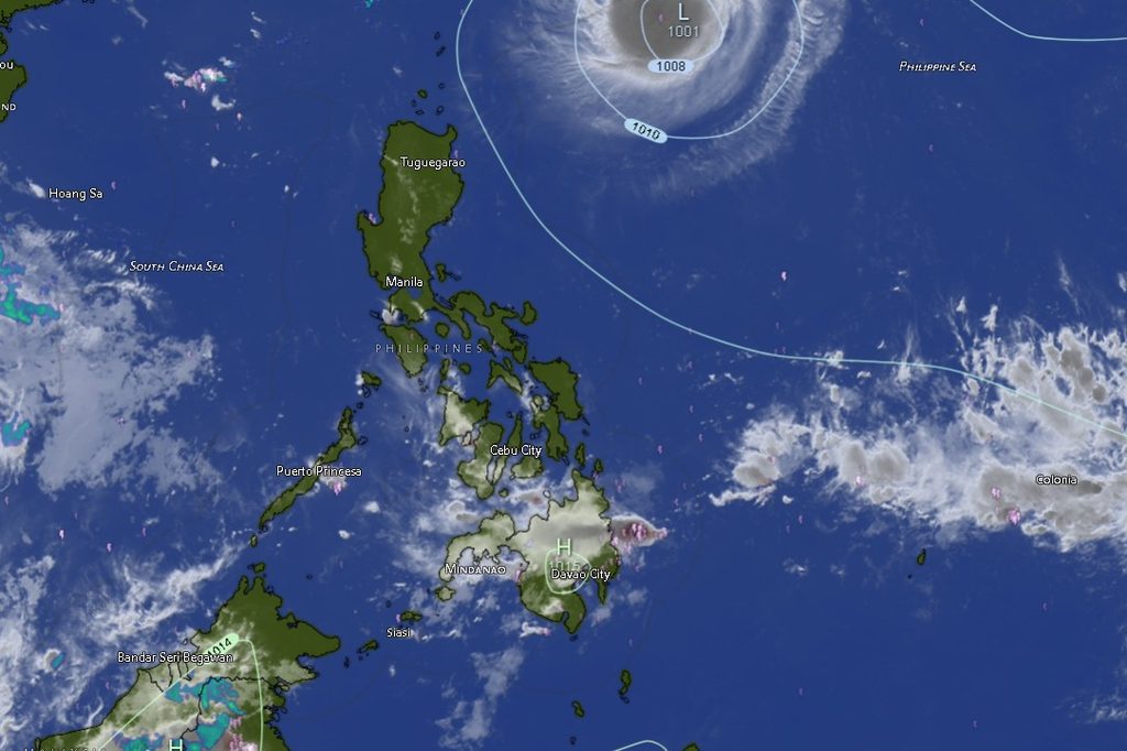
The forecast, edited to reflect an issuance time of 5:00 AM on September 26, 2026, covers the period from 5:00 AM on September 26 until 5:00 AM on September 27.
PAGASA warned that moderate to at times heavy rains associated with thunderstorms could trigger flash floods and landslides, particularly in areas vulnerable to flooding, steep terrain and other rain-induced hazards.
Rainy Conditions Expected in Western and Northern Mindanao
The Zamboanga Peninsula, including Zamboanga City, Zamboanga del Norte, Zamboanga del Sur, Zamboanga Sibugay and Isabela City, is forecast to experience cloudy skies with rain showers and thunderstorms.
Temperatures in the peninsula are expected to remain generally within the mid-20s to low 30s Celsius. Zamboanga City, for instance, is forecast to range from 25°C to 33°C, while Zamboanga del Norte could see temperatures between 25°C and 33°C.
Zamboanga del Sur is expected to range from 23°C to 32°C, while Zamboanga Sibugay may experience temperatures from 24°C to 32°C. Isabela City is forecast to have temperatures between 25°C and 32°C.
The forecast also calls for light to moderate winds from the south to southwest, with coastal waters generally expected to remain at slight to moderate conditions.
Across Northern Mindanao, cloudy skies with rain showers and thunderstorms are likewise expected in Bukidnon, Camiguin, Lanao del Norte, Misamis Occidental and Misamis Oriental.
Bukidnon is forecast to experience temperatures ranging from 20°C to 30°C, while Camiguin may see 23°C to 31°C. Lanao del Norte is expected to range from 24°C to 32°C, Misamis Occidental from 23°C to 30°C, and Misamis Oriental from 25°C to 31°C.
Davao Region Also Faces Thunderstorm Risk
The weather disturbance is also expected to affect the Davao Region, although conditions in several areas are forecast to be partly cloudy to at times cloudy, with rain showers or thunderstorms.
Metro Davao is expected to experience temperatures between 24°C and 31°C.
Davao del Norte could see temperatures ranging from 23°C to 33°C, while Davao del Sur is forecast at 23°C to 32°C.
Davao Oriental is expected to experience cloudy skies with rain showers and thunderstorms, with temperatures between 23°C and 31°C.
Davao de Oro and Davao Occidental are likewise forecast to have partly cloudy to at times cloudy skies with rain showers or thunderstorms. Temperatures could reach 33°C in Davao de Oro and 32°C in Davao Occidental.
Caraga to Remain Cloudy With Rain Showers
In Caraga, cloudy skies accompanied by rain showers and thunderstorms are forecast in Agusan del Norte, Agusan del Sur, Surigao del Norte, Surigao del Sur and the Dinagat Islands.
Agusan del Norte is forecast to reach 34°C, while Agusan del Sur could reach 33°C.
Surigao del Norte and Surigao del Sur may both experience temperatures reaching 34°C, while Dinagat Islands could reach 32°C.
The combination of recurring rain showers and thunderstorms means residents in flood-prone and landslide-prone communities should remain alert, particularly when thunderstorms produce periods of heavier rainfall.
SOCCSKSARGEN, BARMM Also Expect Rain and Thunderstorms
PAGASA also expects partly cloudy to at times cloudy skies with rain showers or thunderstorms across much of SOCCSKSARGEN.
North Cotabato is forecast to experience temperatures from 23°C to 32°C, while South Cotabato could range from 24°C to 33°C.
Sultan Kudarat is expected to record temperatures between 24°C and 33°C, while Sarangani could experience temperatures from 24°C to 34°C.
In the Bangsamoro Autonomous Region in Muslim Mindanao (BARMM), Cotabato City is forecast to experience partly cloudy to at times cloudy skies with rain showers or thunderstorms, with temperatures ranging from 22°C to 33°C.
Basilan, meanwhile, is expected to have cloudy skies with rain showers and thunderstorms, with temperatures between 24°C and 32°C.
Lanao del Sur is forecast to have partly cloudy to at times cloudy skies with rain showers or thunderstorms, with temperatures from 23°C to 31°C.
Sulu and Tawi-Tawi are likewise expected to experience partly cloudy to at times cloudy conditions with rain showers or thunderstorms. Sulu could reach 33°C, while Tawi-Tawi is forecast to range from 26°C to 32°C.
Maguindanao del Norte is expected to experience temperatures between 24°C and 34°C, while Maguindanao del Sur could range from 25°C to 34°C.
Flash Floods, Landslides Remain a Concern
With the ITCZ producing widespread rain showers and thunderstorms over Mindanao, PAGASA’s warning about possible flash floods and landslides remains particularly important for communities located near rivers, streams, low-lying areas and steep or unstable slopes.
Residents are advised to closely monitor local weather conditions, especially during periods of persistent or heavy rainfall. Motorists should also exercise caution on roads where reduced visibility, flooding or landslides could occur.
Coastal communities and sea travelers are likewise advised to monitor local marine conditions, as winds across the region are generally forecast to be light to moderate and coastal waters slight to moderate.
The regional forecast underscores the possibility of rapidly changing conditions, with partly cloudy skies potentially giving way to thunderstorms and heavier rain in affected areas.
PAGASA advises the public and disaster risk reduction and management offices to continue monitoring subsequent weather bulletins and advisories for possible changes in rainfall and thunderstorm conditions.
The weather situation may vary from one locality to another, and residents are urged to rely on the latest PAGASA advisories and instructions from local authorities, particularly in areas vulnerable to flooding and landslides.