
MINDANAO — Residents across Mindanao are advised to remain alert for possible flash floods and landslides as partly cloudy to cloudy skies, accompanied by isolated rainshowers and localized thunderstorms, are expected to prevail across the island over the next 24 hours, according to the Philippine Atmospheric, Geophysical and Astronomical Services Administration (PAGASA).
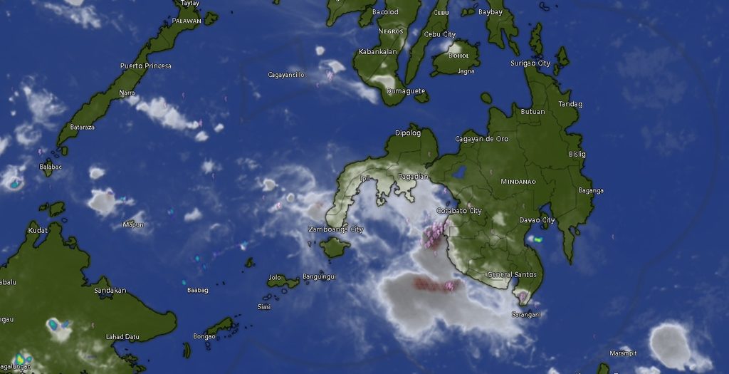
In its Regional Weather Forecast for Mindanao (MINPRSD), issued at 5:00 a.m. on November 4, 2026, PAGASA said the prevailing weather conditions would bring generally fair skies at times, but localized thunderstorms could develop in several areas throughout the forecast period, which runs until 5:00 a.m. on November 5.
The weather agency specifically warned that severe thunderstorms could trigger flash floods or landslides, particularly in areas vulnerable to flooding, communities near rivers and waterways, and locations with unstable slopes.
The forecast covers the Zamboanga Peninsula, Northern Mindanao, Davao Region, SOCCSKSARGEN, Caraga, and the Bangsamoro Autonomous Region in Muslim Mindanao (BARMM).
In the Zamboanga Peninsula, including Zamboanga City, Zamboanga del Norte, Zamboanga del Sur, Zamboanga Sibugay, and Isabela City, partly cloudy to occasionally cloudy skies with rainshowers or thunderstorms are expected. Temperatures are forecast to range from 24 to 31 degrees Celsius during the initial forecast period, with daytime highs potentially reaching 34 degrees.
Similar weather conditions are expected across Northern Mindanao, including Bukidnon, Camiguin, Lanao del Norte, Misamis Occidental, and Misamis Oriental. Bukidnon is expected to experience cooler temperatures, ranging from 19 to 30 degrees Celsius initially, while temperatures in the coastal provinces could reach 33 to 34 degrees.

In the Davao Region, Metro Davao, Davao del Norte, Davao del Sur, Davao Oriental, Davao de Oro, and Davao Occidental will likewise experience partly cloudy to cloudy skies with chances of rainshowers and thunderstorms.
Temperatures in the region are expected to range from 22 to 32 degrees Celsius during the initial period, with daytime temperatures potentially climbing to 35 degrees, particularly in Davao del Norte.
Across SOCCSKSARGEN, including North Cotabato, South Cotabato, Sultan Kudarat, and Sarangani, isolated rainshowers and thunderstorms are also forecast. Temperatures are expected to reach as high as 33 to 34 degrees Celsius during the daytime.
Caraga provinces, including Agusan del Norte, Agusan del Sur, Surigao del Norte, Surigao del Sur, and Dinagat Islands, are similarly expected to experience intermittent rainshowers and thunderstorms. Daytime temperatures could reach 33 to 35 degrees Celsius, with Agusan del Norte forecast to record the highest temperature range in the region.
In BARMM, Cotabato City, Basilan, Lanao del Sur, Sulu, Tawi-Tawi, Maguindanao del Norte, and Maguindanao del Sur will also experience partly cloudy to occasionally cloudy conditions with possible rainshowers and thunderstorms. Temperatures are expected to range from 22 to 34 degrees Celsius, depending on the locality and time of day.
Winds and Coastal Conditions
PAGASA said light to moderate winds blowing from the northeast to southeast are expected across Mindanao during the forecast period.
Coastal waters are generally expected to remain slight to moderate, with wave heights ranging from 0.6 to 1.8 meters. These conditions may allow relatively manageable sea travel, although fishing communities, small-craft operators, and other maritime stakeholders are advised to remain attentive to changing weather conditions, particularly during thunderstorms.
The agency’s forecast indicates that no single province is expected to remain entirely free from the possibility of rainshowers or thunderstorms, making continued weather monitoring important for communities across the island.
Public Advised to Take Precautions
Local disaster risk reduction and management offices, particularly in flood-prone and landslide-susceptible communities, are encouraged to monitor local weather developments and remain prepared for possible weather-related emergencies.
Residents are advised to avoid crossing flooded roads and swollen rivers, especially during and immediately after heavy rainfall. Communities situated near mountain slopes and other landslide-prone areas should also remain vigilant for signs of ground instability.
Motorists are encouraged to exercise caution on roads that may become slippery or experience reduced visibility during sudden downpours. Fisherfolk and sea travelers should likewise monitor coastal conditions and follow advisories from local authorities before undertaking maritime activities.
PAGASA emphasized that localized thunderstorms can develop rapidly and may produce intense rainfall even when surrounding areas experience relatively clear skies.
The regional forecast was prepared by PAGASA-Mindanao, based in El Salvador City, Misamis Oriental, under the Department of Science and Technology (DOST).
For updated weather information and further inquiries, the public may contact PAGASA through 8922-1992 and 8927-1335 or visit its official website at bagong.pagasa.dost.gov.ph.