
GENERAL SANTOS CITY — Several parts of Mindanao are expected to experience cloudy skies, scattered to widespread rains, and thunderstorms on Wednesday, November 11, as the easterlies continue to influence weather conditions across the island, prompting warnings of possible flash floods and landslides in areas affected by moderate to occasionally heavy rainfall.
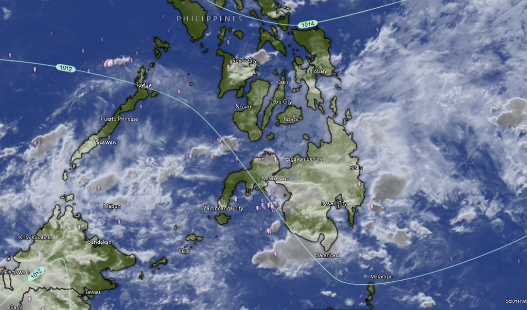
In its regional weather forecast issued at 5:00 a.m. on November 11, the Philippine Atmospheric, Geophysical and Astronomical Services Administration (PAGASA), through its Mindanao Regional Services Division (MINPRSD), said Caraga, the Davao Region, and Northern Mindanao would experience cloudy skies with scattered to widespread rains and thunderstorms throughout the forecast period, which runs until 5:00 a.m. on November 12.
The weather agency warned that moderate to at times heavy rainfall in these areas could trigger flash floods and landslides, particularly in communities near rivers, creeks, steep slopes, and other flood- or landslide-prone locations.
PAGASA also cautioned residents in the rest of Mindanao to remain alert for isolated rain showers and thunderstorms, which may develop under partly cloudy to cloudy skies. Flash floods and landslides remain possible during severe thunderstorms, even in areas not expected to experience widespread rainfall.
Caraga, Davao Region face prolonged rainy conditions
Across Caraga, all five provinces covered in the forecast—Agusan del Norte, Agusan del Sur, Surigao del Norte, Surigao del Sur, and Dinagat Islands—are expected to experience cloudy skies with rain showers and thunderstorms.
Temperatures in Agusan del Norte and Agusan del Sur are forecast to range from 23°C to 31°C, while Surigao del Norte, Surigao del Sur, and Dinagat Islands may experience temperatures between 23°C and 30°C.

Similar conditions are expected throughout the Davao Region, including Metro Davao, Davao del Norte, Davao del Sur, Davao Oriental, Davao de Oro, and Davao Occidental. These areas are forecast to have cloudy skies with rain showers and thunderstorms.
SPONSORED LINK: https://lightlypowerfulgourmet.com/u9i107dsea?key=63025114fa6eb96108de24ad21ec0671
Metro Davao, Davao del Sur, and Davao Oriental are expected to record temperatures of 24°C to 32°C, while Davao del Norte may experience 23°C to 32°C. Davao de Oro and Davao Occidental are forecast to have cooler minimum temperatures of 22°C, with maximum temperatures reaching 32°C.
The expected persistence of rain and thunderstorms across these areas raises concerns for commuters, motorists, farmers, fisherfolk, and residents in communities vulnerable to flooding and slope failures.
Northern Mindanao also under rainy weather outlook
Northern Mindanao will likewise experience cloudy skies with rain showers and thunderstorms, according to PAGASA.
Bukidnon is forecast to have temperatures ranging from 20°C to 32°C, while Camiguin may experience 25°C to 32°C. Lanao del Norte is expected to record 24°C to 32°C, Misamis Occidental 26°C to 33°C, and Misamis Oriental 25°C to 32°C.
The forecast indicates that rainy conditions will affect both inland and coastal communities, making it important for residents to monitor local weather developments, especially during periods of persistent rainfall or thunderstorms.
Zamboanga Peninsula, SOCCSKSARGEN, and BARMM expect occasional showers
Unlike the three regions facing potentially more widespread rainfall, the Zamboanga Peninsula is expected to experience partly cloudy to at times cloudy skies, with isolated rain showers or thunderstorms.
Zamboanga City and Isabela City are forecast to have temperatures between 24°C and 34°C. Zamboanga del Norte may experience 26°C to 33°C, while Zamboanga del Sur and Zamboanga Sibugay are expected to record temperatures of 24°C to 33°C.
In SOCCSKSARGEN, North Cotabato, South Cotabato, Sultan Kudarat, and Sarangani are also expected to experience partly cloudy to at times cloudy skies with isolated rain showers or thunderstorms. Temperatures may reach 33°C in North Cotabato, 34°C in South Cotabato and Sultan Kudarat, and 33°C in Sarangani.
The same general weather pattern is expected across the Bangsamoro Autonomous Region in Muslim Mindanao (BARMM), including Cotabato City, Basilan, Lanao del Sur, Sulu, Tawi-Tawi, Maguindanao del Norte, and Maguindanao del Sur.
Temperatures in these areas are generally forecast to range from 22°C to 34°C, with Lanao del Sur expected to have the lowest minimum temperature at 22°C.
Although these areas are not included in the forecast’s zone of scattered to widespread rainfall, PAGASA emphasized that severe thunderstorms could still produce conditions capable of triggering flash floods and landslides.
Light to moderate winds, slight to moderate coastal conditions
PAGASA said light to moderate winds from the east to northeast are expected across Mindanao during the forecast period.
Coastal waters are generally forecast to remain slight to moderate, with wave heights ranging from 0.6 to 2.1 meters. Despite these conditions, fisherfolk and operators of small fishing vessels are advised to remain attentive to changing weather conditions, particularly when thunderstorms develop.
The combination of rain, thunderstorms, and shifting local weather conditions may affect fishing activities and sea travel, especially in areas where stronger rain-bearing weather systems develop.
Residents urged to take precautions against flooding and landslides
With several regions facing prolonged rainy conditions, residents are advised to monitor official weather bulletins and warnings, avoid crossing flooded roads and waterways, and exercise caution when travelling during heavy rainfall.
Communities near rivers, creeks, drainage channels, and landslide-prone slopes should remain particularly vigilant. Residents should also watch for signs of possible slope instability, including ground cracks, unusual water seepage, falling rocks, and sudden changes in water levels.
Motorists are encouraged to reduce speed and maintain safe distances when driving on rain-soaked roads, while local disaster risk reduction and management offices are urged to monitor vulnerable communities and prepare for possible weather-related emergencies.
PAGASA’s forecast covers the period from 5:00 a.m. Wednesday, November 11, until 5:00 a.m. Thursday, November 12, 2026.