
GENERAL SANTOS CITY — The easterlies will continue to influence weather conditions across Mindanao on Monday, November 9, bringing scattered rains and thunderstorms to parts of the island, with Caraga and Davao Oriental expected to experience cloudy skies and more frequent rainfall, according to the Philippine Atmospheric, Geophysical and Astronomical Services Administration (PAGASA).
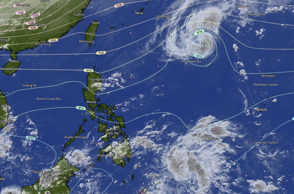
In its regional weather forecast issued at 5:00 a.m. on November 9, PAGASA’s Mindanao station (MINPRSD) said Caraga and Davao Oriental will experience cloudy skies with scattered rainshowers and thunderstorms due to the easterlies. Moderate to at times heavy rainfall could trigger flash floods and landslides, particularly in vulnerable communities and areas with poor drainage or unstable slopes.
The rest of Mindanao, including the Zamboanga Peninsula, Northern Mindanao, Davao Region, SOCCSKSARGEN and the Bangsamoro Autonomous Region in Muslim Mindanao (BARMM), will generally experience partly cloudy to cloudy skies, with isolated rainshowers or thunderstorms.
Although rainfall in these areas is expected to be more localized, PAGASA warned that severe thunderstorms could still bring enough rain to cause flash floods and landslides.
Residents are advised to remain alert, especially those living near rivers, creeks, low-lying communities and landslide-prone areas. Sudden thunderstorms may also affect road visibility and travel conditions.
Caraga and Davao Oriental face increased rainfall exposure
The forecast identifies Caraga as one of the areas likely to experience more persistent rainfall.

Agusan del Norte, Agusan del Sur, Surigao del Norte, Surigao del Sur and Dinagat Islands are expected to have cloudy skies with rainshowers and thunderstorms throughout the forecast period.
Temperatures in Caraga provinces are expected to range from 23°C to 32°C, depending on the locality and forecast period. Surigao del Norte and Surigao del Sur may experience relatively cooler conditions, with temperatures reaching lows of 23°C to 24°C.
Davao Oriental will likewise experience cloudy skies with rainshowers and thunderstorms, with temperatures ranging from 24°C to 33°C.
The weather conditions warrant particular attention from communities in flood-prone and landslide-susceptible locations, as moderate to occasionally heavy rainfall may increase the risk of sudden flooding and slope failures.
Other parts of Mindanao to experience localized thunderstorms
Across the Zamboanga Peninsula, partly cloudy to occasionally cloudy skies with rainshowers or thunderstorms are expected in Zamboanga City, Zamboanga del Norte, Zamboanga del Sur, Zamboanga Sibugay and Isabela City.
Temperatures will generally range from 23°C to 35°C, with Zamboanga City forecast to reach a high of 33°C on Monday before potentially rising to 35°C in the succeeding forecast period.
Northern Mindanao will also experience partly cloudy to occasionally cloudy skies with isolated rainshowers or thunderstorms. Bukidnon is expected to record temperatures between 19°C and 33°C, while Camiguin, Lanao del Norte, Misamis Occidental and Misamis Oriental will have temperatures generally ranging from 24°C to 31°C.
In the Davao Region, Metro Davao, Davao del Norte, Davao del Sur, Davao de Oro and Davao Occidental will experience partly cloudy to cloudy skies with rainshowers or thunderstorms. Davao del Sur could reach 34°C, while Davao del Norte may record temperatures of up to 34°C.
SOCCSKSARGEN provinces, including North Cotabato, South Cotabato, Sultan Kudarat and Sarangani, will likewise experience partly cloudy to occasionally cloudy skies with isolated rainshowers or thunderstorms.
Temperatures across the region are expected to range from 22°C to 35°C, with South Cotabato potentially reaching the highest forecast temperature of 35°C.
In BARMM, Cotabato City, Basilan, Lanao del Sur, Sulu, Tawi-Tawi, Maguindanao del Norte and Maguindanao del Sur will generally have partly cloudy to occasionally cloudy skies with rainshowers or thunderstorms.
Lanao del Sur will experience relatively cooler temperatures, ranging from 21°C to 30°C, while Cotabato City and Maguindanao del Norte could reach highs of 34°C.
Light to moderate winds, slight to moderate seas
PAGASA said light to moderate winds from the east to northeast will prevail across Mindanao.
Coastal waters are expected to remain slight to moderate, with wave heights ranging from 0.6 to 2.1 meters.
While these conditions generally indicate relatively manageable sea conditions, fishing communities, small-craft operators and other maritime stakeholders are advised to continue monitoring local weather developments, particularly when thunderstorms approach coastal areas.
Typhoon Cempaka remains outside the Philippine Area of Responsibility
Meanwhile, PAGASA’s tropical cyclone bulletin included information on Typhoon Cempaka (international designation 2632), which remained outside the Philippine Area of Responsibility (PAR).
As of 3:00 p.m. on November 8, the typhoon was located approximately 1,620 kilometers east of extreme Northern Luzon, near 22.0°N and 137.4°E.
Cempaka had maximum sustained winds of 120 kilometers per hour near its center and gustiness of up to 150 kilometers per hour. It was moving west-northwestward at 20 kilometers per hour.
The available MINPRSD forecast identifies the easterlies, rather than the distant tropical cyclone, as the prevailing weather system affecting Mindanao.
Residents urged to remain vigilant
PAGASA’s rainfall warning underscores the importance of preparedness even in areas where thunderstorms are expected to be isolated.
Local disaster risk reduction and management offices, particularly in communities vulnerable to flooding and landslides, are encouraged to monitor changing weather conditions and issue timely advisories when necessary.
Residents should avoid crossing flooded roads and waterways, stay away from steep slopes during prolonged or heavy rainfall, and secure properties and outdoor equipment before thunderstorms develop.
Motorists are also advised to exercise caution on slippery roads and in areas where poor visibility may accompany sudden downpours.
The regional forecast is valid from 5:00 a.m. on November 9 until 5:00 a.m. on November 10, 2026. PAGASA advised the public to monitor subsequent weather updates through its official channels.
Source: PAGASA Mindanao (MINPRSD)