
GENERAL SANTOS CITY, Philippines — The Southwest Monsoon is expected to continue affecting the Zamboanga Peninsula on Sunday, September 20, bringing partly cloudy to cloudy skies, isolated rainshowers and thunderstorms, while the rest of Mindanao will likewise experience localized rainshowers and thunderstorms, according to the Philippine Atmospheric, Geophysical and Astronomical Services Administration (PAGASA).
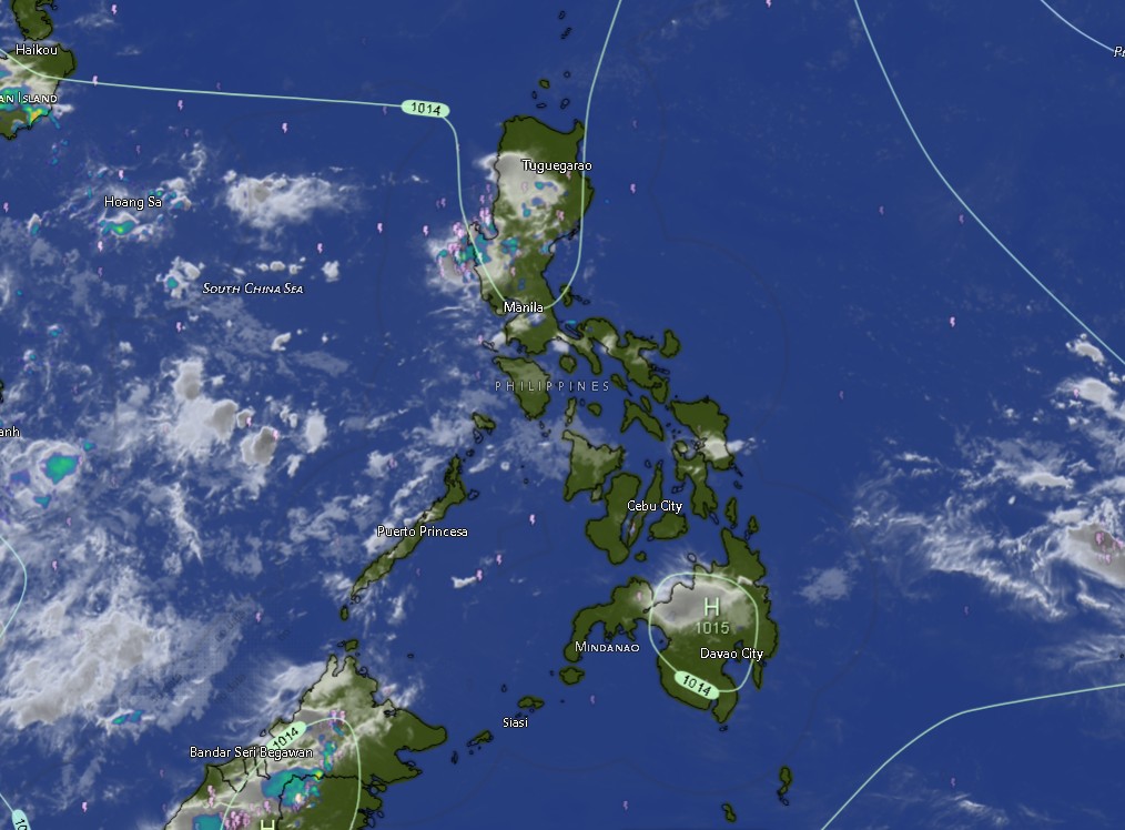
The Mindanao PAGASA Regional Services Division (MINPRSD) issued its regional weather forecast at 5:00 a.m. on September 20, 2026, covering the period from 5:00 a.m. Sunday until 5:00 a.m. Monday.
PAGASA said the Zamboanga Peninsula will be directly affected by the Southwest Monsoon, locally known as habagat. The region, including Zamboanga City, Zamboanga del Norte, Zamboanga del Sur, Zamboanga Sibugay and Isabela City, is forecast to experience partly cloudy skies that may become cloudy at times, with rainshowers or thunderstorms.
The weather agency also warned that severe thunderstorms could trigger flash floods or landslides, particularly in areas that receive intense or prolonged rainfall.
The warning is significant for communities near rivers, creeks, waterways, steep slopes and other areas vulnerable to sudden flooding or rain-induced landslides.
PAGASA’s current regional forecast is consistent with its broader outlook that the Southwest Monsoon will continue affecting western portions of Mindanao, particularly the Zamboanga Peninsula.
Rain and Thunderstorms Across Mindanao
Outside the Zamboanga Peninsula, the remainder of Mindanao is expected to have partly cloudy to cloudy skies with isolated rainshowers or localized thunderstorms.
This includes provinces and areas across Northern Mindanao, Davao Region, SOCCSKSARGEN, Caraga and the Bangsamoro Autonomous Region in Muslim Mindanao (BARMM).
In Northern Mindanao, Bukidnon is forecast to record temperatures ranging from 19°C to 31°C during the current period, rising to as high as 33°C during the following forecast period.
Camiguin may experience temperatures between 25°C and 30°C, while Lanao del Norte is expected to range from 21°C to 28°C. Misamis Occidental is forecast at 25°C to 31°C, while Misamis Oriental may reach 32°C.
The Davao Region will also remain vulnerable to localized rain and thunderstorms. Metro Davao is forecast to experience temperatures from 26°C to 31°C, rising to as high as 33°C during the succeeding period.
Davao del Norte is expected to range from 24°C to 31°C, Davao del Sur from 23°C to 30°C, Davao Oriental from 24°C to 31°C, Davao de Oro from 24°C to 33°C, and Davao Occidental from 24°C to 30°C.
In SOCCSKSARGEN, North Cotabato is forecast at 24°C to 33°C, while South Cotabato is expected to range from 24°C to 31°C. Sultan Kudarat is forecast at 24°C to 30°C, while Sarangani may experience temperatures between 25°C and 31°C.
PAGASA is also forecasting rainshowers or thunderstorms over Cotabato City and the BARMM provinces, including Basilan, Lanao del Sur, Sulu, Tawi-Tawi, Maguindanao del Norte and Maguindanao del Sur.
Temperatures in these areas are generally expected to remain in the 23°C to 34°C range, depending on location and forecast period.
Caraga Also Faces Thunderstorm Risk
Across Caraga, partly cloudy to cloudy conditions with rainshowers or thunderstorms are also expected.
Agusan del Norte is forecast to experience temperatures between 26°C and 32°C, while Agusan del Sur is expected to range from 24°C to 32°C.
Surigao del Norte may reach 32°C, while Surigao del Sur is forecast between 25°C and 31°C. Dinagat Islands is expected to range from 26°C to 31°C.
The forecast indicates that thunderstorms may develop locally rather than affecting the entire region continuously. However, PAGASA’s warning regarding flash floods and landslides during severe thunderstorms means that residents should remain alert when thunderstorms become intense.
PAGASA’s regional forecast currently lists the general weather pattern across Mindanao as partly cloudy to cloudy skies with rainshowers or thunderstorms, with light to moderate winds generally coming from the southwest to west.
Coastal Waters Remain Slight to Moderate
For coastal communities and those engaged in fishing and maritime activities, PAGASA forecasts slight to moderate seas, with wave conditions generally ranging from 0.6 to 1.8 meters.
Winds across the region are expected to remain light to moderate from southwest to west.
While these conditions are not forecast to be uniformly hazardous, fishermen, boat operators and other small-craft users are advised to monitor the latest local weather and marine advisories, particularly when thunderstorms develop.
Thunderstorms can produce sudden changes in wind and sea conditions even when the general coastal forecast remains within the slight-to-moderate category.
Zamboanga Peninsula Under Southwest Monsoon Influence
Among Mindanao’s regions, the Zamboanga Peninsula remains the area specifically identified by PAGASA as being affected by the Southwest Monsoon.
Zamboanga City is forecast to experience temperatures between 25°C and 32°C, while Zamboanga del Norte could reach 33°C. Zamboanga del Sur and Zamboanga Sibugay are forecast at around 23°C to 30°C, while Isabela City may experience temperatures between 24°C and 31°C.
During the succeeding forecast period, maximum temperatures could rise to 35°C in Zamboanga del Norte, 34°C in Zamboanga City, and 33°C in Isabela City.
Despite the potentially warm daytime temperatures, localized thunderstorms may still develop, producing periods of heavy rain over affected communities.
PAGASA has likewise maintained that the Southwest Monsoon is expected to continue influencing the western sections of the country, including the Zamboanga Peninsula, while the rest of Mindanao may experience localized thunderstorms.
Residents Urged to Monitor Thunderstorm Development
The possibility of flash floods and landslides during severe thunderstorms remains the principal weather-related concern in the latest MINPRSD forecast.
Residents in flood-prone and landslide-prone communities are urged to monitor official weather bulletins, particularly when thunderstorms become persistent or rainfall intensifies.
Motorists should also exercise caution on roads affected by sudden flooding, poor visibility or landslides, while communities near waterways should remain alert to rapidly rising water levels.
PAGASA’s Mindanao forecast page also provides updates on thunderstorm watches and other regional weather advisories. As of its latest available regional update, a thunderstorm watch had identified several Davao Region areas as more likely to experience thunderstorms within a 12-hour period.
The public is advised to rely on official PAGASA bulletins for any changes in the weather situation, including the issuance of rainfall warnings, thunderstorm advisories or other weather-related alerts.
The Mindanao Sentinel will continue monitoring weather developments across Mindanao and provide updates as new advisories are issued.