
COTABATO CITY, Philippines – Most parts of Mindanao will continue to experience partly cloudy to cloudy skies with isolated rainshowers and thunderstorms over the next 24 hours as localized thunderstorms persist across the island, according to the latest Regional Weather Forecast issued by the Philippine Atmospheric, Geophysical and Astronomical Services Administration (PAGASA) Mindanao Regional Services Division (MINPRSD) at 5:00 a.m. on Monday, August 3.
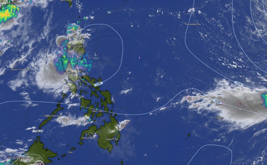
Although Tropical Depression (TD) “Luis” remains over Luzon, its presence, combined with localized thunderstorm activity, continues to influence weather conditions across parts of the country.
As of 3:00 a.m., PAGASA located the center of TD Luis approximately 130 kilometers east of Casiguran, Aurora at coordinates 15.9°N, 123.3°E. The cyclone packs maximum sustained winds of 55 kilometers per hour, gustiness of up to 70 km/h, and is reported to be almost stationary.
Despite the tropical depression being far from Mindanao, PAGASA emphasized that residents throughout the island should remain vigilant as localized thunderstorms may still trigger flash floods and landslides, particularly in low-lying and mountainous communities experiencing intense rainfall.
Thunderstorms Expected Across Entire Mindanao
The forecast indicates that virtually all provinces in Mindanao, including the Zamboanga Peninsula, Northern Mindanao, Davao Region, SOCCSKSARGEN, Caraga Region, and the Bangsamoro Autonomous Region in Muslim Mindanao (BARMM), will experience partly cloudy skies becoming cloudy at times with rainshowers and thunderstorms throughout both daytime and nighttime periods.
Weather forecasters noted that while prolonged rainfall is not expected in all areas, thunderstorms may become severe and produce heavy downpours capable of causing localized flooding, especially during the afternoon and evening.
Winds and Sea Conditions
Across much of Mindanao, light to moderate south to southwest winds will prevail with slight to moderate coastal waters ranging from 0.6 to 1.5 meters, generally favorable for most small sea vessels.
However, stronger winds and rougher seas are expected along the eastern and southeastern coastal areas.
Moderate to strong south to southwest winds with moderate to rough seas are forecast over:
- Davao Oriental
- Davao Occidental
- Sarangani
- Surigao del Norte
- Surigao del Sur
- Dinagat Islands
PAGASA advised fishermen and operators of small fishing boats to exercise caution when venturing into these waters due to potentially rough sea conditions.
Temperature Outlook
Daytime temperatures across Mindanao are expected to range between 20°C and 35°C, depending on location.
Among the warmest areas forecast are:
- Basilan – up to 35°C
- Agusan del Norte – 35°C
- Agusan del Sur – 35°C
- Maguindanao del Sur – 35°C
- Zamboanga City and Isabela City – 35°C
Meanwhile, cooler temperatures are expected over elevated areas such as Bukidnon and Lanao del Sur, where temperatures could fall to 20°C.
Typhoon Dolphin Remains Outside PAR
Meanwhile, PAGASA continues to monitor Typhoon Dolphin (International Name: 2613), which remains well outside the Philippine Area of Responsibility (PAR).
As of 3:00 a.m., Dolphin was located approximately 2,850 kilometers east of Extreme Northern Luzon with maximum sustained winds of 155 km/h, gustiness reaching 190 km/h, and moving west-northwestward at 25 km/h.
The typhoon currently poses no direct threat to the Philippines but continues to be monitored by weather authorities.
Public Advisory
PAGASA urges residents across Mindanao to remain alert for rapidly changing weather conditions, particularly during afternoon and evening thunderstorms. Communities living in flood-prone and landslide-susceptible areas are advised to monitor official weather bulletins and heed warnings from local disaster risk reduction and management offices.
Motorists are likewise encouraged to exercise caution during periods of heavy rainfall due to reduced visibility and slippery road conditions, while coastal communities and fishermen are advised to monitor sea conditions before undertaking marine activities.
The regional weather forecast remains valid from 5:00 a.m. on August 3 until 5:00 a.m. on August 4, 2026.