
GENERAL SANTOS CITY — Much of Mindanao is expected to experience cloudy skies, rainshowers and thunderstorms on Thursday, September 17, as the Intertropical Convergence Zone (ITCZ) and a low pressure area (LPA) continue to influence weather conditions across the region.
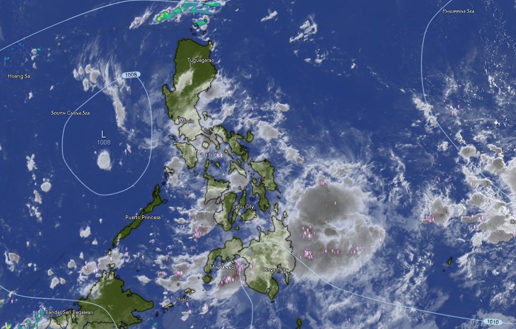
The Philippine Atmospheric, Geophysical and Astronomical Services Administration (PAGASA) Mindanao PAGASA Regional Services Division (MINPRSD) issued the regional weather forecast at 5 a.m. on September 17, covering the period from 5 a.m. Thursday until 5 a.m. Friday.
PAGASA said Zamboanga Peninsula, the Bangsamoro Autonomous Region in Muslim Mindanao (BARMM), Northern Mindanao, Caraga, Davao del Norte, Davao de Oro and Davao Oriental will generally have cloudy skies with scattered rains and thunderstorms due to the combined influence of the ITCZ and LPA.
The weather agency warned that flash floods and landslides are possible, particularly in areas affected by moderate to at times heavy rainfall.
Thunderstorms Possible Across the Rest of Mindanao
The rest of Mindanao will experience partly cloudy to cloudy skies with isolated rainshowers or thunderstorms associated with the ITCZ.
PAGASA also warned that flash floods and landslides may occur during severe thunderstorms, making residents in flood-prone, low-lying and landslide-susceptible areas vulnerable to sudden changes in weather conditions.
Among the areas forecast to have cloudy conditions with rainshowers and thunderstorms are Zamboanga City, Zamboanga del Norte, Zamboanga del Sur, Zamboanga Sibugay and Isabela City.
Northern Mindanao provinces, including Bukidnon, Camiguin, Lanao del Norte, Misamis Occidental and Misamis Oriental, are likewise expected to experience rainshowers and thunderstorms.
In the Davao Region, Davao del Norte, Davao de Oro and Davao Oriental are forecast to have cloudy skies with rainshowers and thunderstorms. Metro Davao, Davao del Sur and Davao Occidental may experience partly cloudy skies that could become cloudy at times, accompanied by rainshowers or thunderstorms.
SOCCSKSARGEN May See Isolated Thunderstorms
Across SOCCSKSARGEN, North Cotabato, South Cotabato, Sultan Kudarat and Sarangani are expected to have partly cloudy skies to at times cloudy conditions, with rainshowers or thunderstorms.
Temperatures are forecast to reach as high as 33°C in Sarangani, while South Cotabato could see temperatures ranging from 20°C to 30°C during the day and 20°C to 28°C at night.
North Cotabato is forecast at 23°C to 32°C during the day, while Sultan Kudarat may reach 31°C.
Caraga Faces Rain and Thunderstorm Risk
All areas covered by the Caraga forecast are expected to experience cloudy skies with rainshowers and thunderstorms.
Agusan del Norte is forecast to reach 31°C, while Agusan del Sur could reach 34°C, the highest daytime temperature listed in the regional forecast.
Surigao del Norte is expected to range from 24°C to 31°C, while Surigao del Sur and Dinagat Islands could reach 32°C during the day.
Rainshowers and thunderstorms are also expected to continue into the evening and overnight period.
BARMM Areas Also Under Rain and Thunderstorm Forecast
Cloudy skies with rainshowers and thunderstorms are forecast across the BARMM areas covered by the MINPRSD forecast, including Cotabato City, Basilan, Lanao del Sur, Sulu, Tawi-Tawi, Maguindanao del Norte and Maguindanao del Sur.
Daytime temperatures are expected to reach 33°C in Maguindanao del Sur, while Tawi-Tawi is forecast to range from 26°C to 31°C.
The forecast indicates that rainshowers and thunderstorms may continue from Thursday evening into the early hours of Friday across these areas.
Light to Moderate Winds, Slight to Moderate Seas
PAGASA said winds across the region will generally be light to moderate, coming from the southwest to southeast.
Coastal waters are expected to remain slight to moderate, with wave heights generally ranging from 0.6 to 2.5 meters.
The conditions mean that residents and travelers in coastal communities, as well as small-craft operators and fishing communities, should continue monitoring local weather developments, particularly when thunderstorms develop over or near coastal waters.
Public Urged to Remain Alert
With the possibility of moderate to at times heavy rainfall and severe thunderstorms, residents in communities prone to flooding and landslides are advised to remain alert throughout the forecast period.
Sudden downpours can rapidly increase water levels in rivers, creeks and drainage channels, while prolonged or intense rainfall may destabilize slopes in mountainous and landslide-prone areas.
PAGASA’s forecast covers the period from 5 a.m. Thursday, September 17, until 5 a.m. Friday, September 18, and conditions may change as weather systems develop.
Residents are encouraged to monitor official PAGASA bulletins and advisories, particularly during periods of thunderstorms and heavy rainfall.
Forecast source: Philippine Atmospheric, Geophysical and Astronomical Services Administration (PAGASA) — Mindanao PAGASA Regional Services Division (MINPRSD), issued at 5 a.m., September 17, 2026.