
MINDANAO, Philippines – Residents across Mindanao should remain alert for isolated rain showers and thunderstorms over the next 24 hours as localized thunderstorms continue to affect the island, according to the latest Regional Weather Forecast issued by the Philippine Atmospheric, Geophysical and Astronomical Services Administration (PAGASA) Mindanao Regional Services Division (MINPRSD) at 5:00 a.m. on Thursday, July 30, 2026.
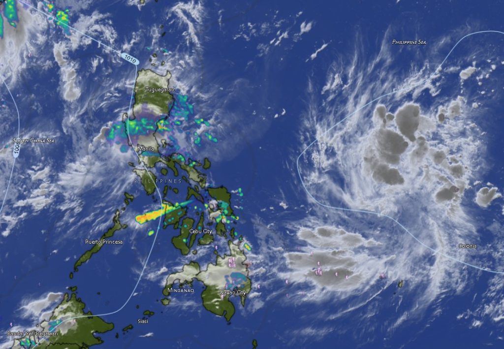
PAGASA said that while much of Mindanao will generally experience partly cloudy to cloudy skies, localized thunderstorms developing throughout the day could trigger moderate to heavy rainfall, increasing the risk of flash floods and landslides, particularly in low-lying communities, flood-prone areas, and mountainous terrain.
The weather bureau also noted that as of 3:00 p.m. Wednesday, a Low Pressure Area (LPA) was estimated in the vicinity of Macalelon, Quezon (13.8°N, 122.2°E). Although the LPA is outside Mindanao, the island’s weather will primarily be influenced by localized thunderstorms, which are common during the rainy season.
Rain Showers Possible Across All Mindanao Regions
PAGASA forecasts similar weather conditions across the entire island, with all regions expected to experience partly cloudy skies becoming cloudy at times with rain showers and thunderstorms.
The affected areas include:
- Zamboanga Peninsula – Zamboanga City, Zamboanga del Norte, Zamboanga del Sur, Zamboanga Sibugay, and Isabela City.
- Northern Mindanao – Bukidnon, Camiguin, Lanao del Norte, Misamis Occidental, and Misamis Oriental.
- Davao Region – Davao de Oro, Davao del Norte, Davao del Sur, Davao Oriental, Davao Occidental, and Metro Davao.
- SOCCSKSARGEN – North Cotabato, South Cotabato, Sultan Kudarat, and Sarangani.
- Caraga Region – Agusan del Norte, Agusan del Sur, Surigao del Norte, Surigao del Sur, and Dinagat Islands.
- Bangsamoro Autonomous Region in Muslim Mindanao (BARMM) – Cotabato City, Basilan, Lanao del Sur, Sulu, Tawi-Tawi, Maguindanao del Norte, and Maguindanao del Sur.
While widespread heavy rainfall is not expected, PAGASA emphasized that localized thunderstorms can rapidly intensify, bringing brief but heavy downpours capable of causing flooding in urban centers and landslides in elevated areas.
Light to Moderate Winds, Slight to Moderate Seas
Across Mindanao’s coastal waters, light to moderate winds blowing from the south to southwest will prevail throughout the forecast period.
Sea conditions are expected to remain slight to moderate, with wave heights ranging from 0.6 to 2.1 meters, making conditions generally favorable for most small fishing vessels and sea travel. However, mariners are advised to remain cautious, as thunderstorms may produce sudden strong winds and rougher seas.
Temperature Outlook
Forecast temperatures across Mindanao remain warm, with daytime highs generally ranging between 29°C and 33°C, while nighttime and early morning temperatures are expected to fall between 19°C and 27°C, depending on location.
Among the cooler areas is Lanao del Sur, where temperatures may dip to 19°C, while warmer provinces such as Zamboanga del Norte, Sultan Kudarat, Agusan del Norte, Surigao del Sur, North Cotabato, and Maguindanao del Sur could see temperatures reach 33°C.
Public Advised to Stay Weather-Aware
PAGASA is urging residents to closely monitor weather updates, particularly those living in communities vulnerable to flooding and landslides. Afternoon and evening thunderstorms can develop rapidly, reducing visibility on roads and causing sudden rises in rivers and creeks.
Motorists are advised to exercise caution during heavy rains, while fishermen and small boat operators should remain vigilant for sudden thunderstorms despite generally favorable sea conditions.
The regional weather forecast remains valid from 5:00 a.m. on July 30 until 5:00 a.m. on July 31, 2026, with PAGASA continuing to monitor the Low Pressure Area and other weather systems that may affect the country.