
GENERAL SANTOS CITY, Philippines — October 30, 2026 — Several areas across Mindanao are expected to experience cloudy skies, scattered rains and thunderstorms on Friday, with the Zamboanga Peninsula, Northern Mindanao and Caraga facing an increased risk of flash floods and landslides due to moderate to at times heavy rainfall, according to the Philippine Atmospheric, Geophysical and Astronomical Services Administration (PAGASA).
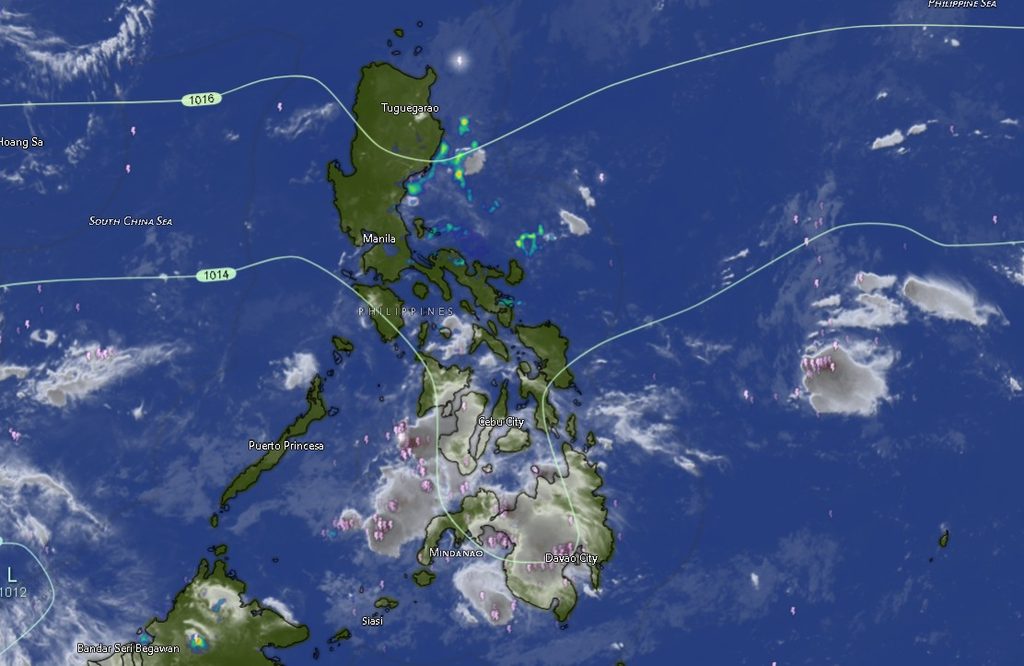
In its regional weather forecast issued at 5 a.m. on October 30, PAGASA’s Mindanao station (MINPRSD) said the trough of a low-pressure area (LPA) will influence weather conditions over the three regions, bringing cloudy skies with scattered rains and isolated thunderstorms. The agency warned that moderate to occasionally heavy rainfall could trigger flooding in low-lying areas and landslides in mountainous and landslide-prone communities.
The rest of Mindanao will generally experience partly cloudy to cloudy skies, with isolated rain showers or thunderstorms caused by localized thunderstorms. Although rainfall may be less widespread in these areas, PAGASA cautioned that severe thunderstorms could still cause flash floods or landslides.
The forecast is valid from 5 a.m. Friday until 5 a.m. Saturday, October 31.
Zamboanga Peninsula faces persistent rain and thunderstorms
The Zamboanga Peninsula is among the areas expected to experience cloudy skies with rain showers and thunderstorms throughout the forecast period.
Zamboanga City is forecast to have temperatures ranging from 25°C to 33°C during the day, potentially reaching 35°C in the subsequent forecast period. Zamboanga del Norte is expected to experience temperatures of 26°C to 30°C, while Zamboanga del Sur and Zamboanga Sibugay may record temperatures between 25°C and 31°C.
Isabela City will have partly cloudy skies, becoming cloudy at times, with possible rain showers or thunderstorms. Temperatures are expected to range from 25°C to 33°C.
Winds across the peninsula will generally be light to moderate, coming from the northeast to east. Coastal waters are forecast to remain slight to moderate, with conditions requiring continued caution from fishers and other small-craft operators, particularly during thunderstorms.
Northern Mindanao and Caraga at risk of flooding
Northern Mindanao will also experience cloudy skies with rain showers and thunderstorms as the LPA trough influences the region.
Bukidnon is expected to have temperatures ranging from 22°C to 30°C, while Camiguin may experience temperatures of 26°C to 30°C. Lanao del Norte is forecast to record 24°C to 29°C, while Misamis Occidental and Misamis Oriental may experience temperatures ranging from 26°C to 30°C and 25°C to 30°C, respectively.
Caraga will likewise experience cloudy skies with rain showers and thunderstorms. Agusan del Norte is forecast to have temperatures between 26°C and 33°C, while Agusan del Sur may reach 34°C.
Surigao del Norte is expected to record temperatures of 26°C to 30°C, Surigao del Sur 26°C to 31°C, and Dinagat Islands 26°C to 30°C.
With moderate to at times heavy rainfall possible in these regions, residents in flood-prone communities, areas near rivers and waterways, and locations with a history of landslides are advised to remain alert. Sudden downpours may cause water levels to rise rapidly, while saturated slopes may become unstable.
Davao Region, SOCCSKSARGEN and parts of BARMM to see isolated thunderstorms
The Davao Region is expected to experience partly cloudy to cloudy skies, with isolated rain showers or thunderstorms.
Metro Davao may register temperatures between 24°C and 33°C, while Davao del Norte and Davao del Sur are forecast to experience temperatures of 25°C to 33°C. Davao Oriental may record 24°C to 33°C. Davao de Oro is expected to have temperatures ranging from 22°C to 30°C, while Davao Occidental may experience 25°C to 31°C.
The forecast indicates that rainfall in these areas will be more localized than in the western and northeastern portions of Mindanao. However, thunderstorms may still produce intense rainfall over specific communities, potentially causing localized flooding.
In SOCCSKSARGEN, North Cotabato is expected to experience temperatures of 23°C to 32°C. South Cotabato may record 23°C to 32°C, Sultan Kudarat 24°C to 30°C, and Sarangani 23°C to 31°C. Partly cloudy to cloudy skies, with isolated rain showers or thunderstorms, are expected across the region.
Similar weather conditions are forecast across the Bangsamoro Autonomous Region in Muslim Mindanao (BARMM). Cotabato City may experience temperatures between 25°C and 31°C, while Basilan is forecast to reach 33°C. Lanao del Sur may record cooler temperatures of 21°C to 28°C.
Sulu and Maguindanao del Norte are expected to experience temperatures of 25°C to 31°C, while Tawi-Tawi may reach 31°C. Maguindanao del Sur is forecast to have temperatures ranging from 25°C to 31°C.
These areas may experience localized thunderstorms, and residents should not assume that partly cloudy conditions eliminate the risk of sudden heavy rainfall.
Northeast to north winds, slight to moderate coastal waters
PAGASA forecasts light to moderate winds generally coming from the northeast to north across Mindanao. Coastal waters are expected to range from 0.6 to 2.1 meters, corresponding to slight to moderate sea conditions.
While these conditions may be manageable under normal circumstances, fishers, boat operators and other people traveling by sea should remain attentive to changing weather, particularly in areas experiencing thunderstorms and rain showers.
Sudden changes in wind and rainfall can affect visibility and travel conditions. Sea users are advised to follow local advisories and instructions from the Philippine Coast Guard and other maritime authorities.
Residents urged to take precautions against floods and landslides
PAGASA’s forecast highlights the need for vigilance, particularly in Zamboanga Peninsula, Northern Mindanao and Caraga, where the trough of the LPA is expected to bring more widespread rainfall.
Residents in low-lying and flood-prone areas should monitor water levels and prepare for possible evacuation if local authorities issue warnings. Those living near steep slopes, ravines and landslide-prone terrain should watch for signs of ground instability, including new cracks, unusual ground movement and sudden changes in water flow.
The public is also advised to avoid crossing flooded roads and rivers, especially when water is moving rapidly or its depth is uncertain. Outdoor activities should be postponed when thunderstorms occur, and people should seek shelter in safe buildings rather than remaining in exposed areas.
Local disaster risk reduction and management offices are encouraged to monitor conditions closely and disseminate timely warnings to vulnerable communities.
PAGASA emphasized that severe thunderstorms can generate dangerous local impacts even in areas not expected to experience widespread rain. Residents are therefore advised to continue monitoring official weather bulletins and local government advisories throughout the forecast period.