
GENERAL SANTOS CITY, Philippines — Residents across Mindanao are advised to remain alert as a low-pressure area (LPA) is expected to bring cloudy skies, scattered rain showers and thunderstorms across the island on Saturday, October 31, with moderate to occasionally heavy rainfall potentially triggering flash floods and landslides in vulnerable communities.
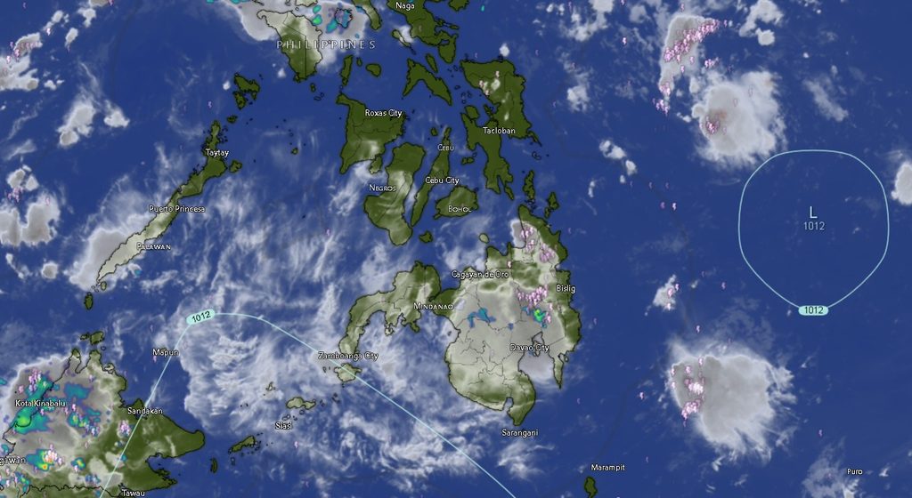
In its Regional Weather Forecast issued at 5:00 a.m. on October 31, the Philippine Atmospheric, Geophysical and Astronomical Services Administration (PAGASA) Mindanao Regional Services Division (MINPRSD) said the weather disturbance would affect the entire Mindanao region during the 24-hour forecast period, from 5:00 a.m. Saturday until 5:00 a.m. Sunday, November 1.
The weather agency warned that periods of moderate to at times heavy rainfall could increase the risk of flash floods and landslides, particularly in low-lying communities, areas near rivers and waterways, and locations with steep or unstable slopes.
The forecast indicates that no major part of Mindanao will be spared from the unsettled weather, with rain showers and thunderstorms expected across the Zamboanga Peninsula, Northern Mindanao, Davao Region, SOCCSKSARGEN, Caraga and the Bangsamoro Autonomous Region in Muslim Mindanao (BARMM).
Rain and thunderstorms expected across Mindanao
In the Zamboanga Peninsula, cloudy skies with rain showers and thunderstorms are forecast in Zamboanga City, Zamboanga del Norte, Zamboanga del Sur, Zamboanga Sibugay and Isabela City.
Temperatures are expected to range from 24°C to 31°C in Zamboanga del Sur, 24°C to 32°C in Zamboanga Sibugay, 25°C to 31°C in Zamboanga City and 25°C to 29°C in Zamboanga del Norte. Isabela City is expected to experience temperatures between 25°C and 31°C.
Northern Mindanao will likewise experience cloudy conditions with rain showers and thunderstorms. Bukidnon is forecast to have temperatures of 20°C to 30°C, while Camiguin may experience 25°C to 30°C. Lanao del Norte and Misamis Occidental are expected to record temperatures of 25°C to 28°C, while Misamis Oriental may have temperatures ranging from 25°C to 29°C.
Across the Davao Region, Metro Davao, Davao del Norte, Davao del Sur and Davao Oriental are expected to experience similar weather conditions. Forecast temperatures are between 26°C and 32°C in Metro Davao, 25°C and 32°C in Davao del Norte, 24°C and 32°C in Davao del Sur, and 24°C and 33°C in Davao Oriental.
SOCCSKSARGEN and Caraga also face rainy conditions
Residents of SOCCSKSARGEN should also prepare for rain showers and thunderstorms throughout the forecast period.
North Cotabato is expected to have temperatures between 23°C and 30°C, while South Cotabato may experience 24°C to 31°C. Sultan Kudarat is forecast to have temperatures ranging from 25°C to 29°C, while Sarangani is expected to record 25°C to 30°C.
In Caraga, cloudy skies with rain showers and thunderstorms are forecast in Agusan del Norte, Agusan del Sur, Surigao del Norte, Surigao del Sur and the Dinagat Islands.
Agusan del Norte is expected to experience temperatures of 26°C to 32°C, while Agusan del Sur may have 24°C to 30°C. Surigao del Norte is forecast to record 26°C to 31°C, Surigao del Sur 23°C to 30°C, and the Dinagat Islands 26°C to 32°C.
Rainy weather to persist across BARMM
The unsettled weather will also affect communities across BARMM, including Cotabato City, Basilan, Lanao del Sur, Sulu, Tawi-Tawi, Maguindanao del Norte and Maguindanao del Sur.
Cotabato City is forecast to have temperatures between 23°C and 29°C, while Basilan may experience 23°C to 30°C. Lanao del Sur is expected to record cooler temperatures of 21°C to 28°C.
In the island provinces, temperatures are forecast to range from 25°C to 31°C in Sulu and 26°C to 31°C in Tawi-Tawi. Maguindanao del Norte and Maguindanao del Sur are both expected to experience temperatures between 23°C and 30°C.
Northeast to north winds; coastal waters remain relatively manageable
PAGASA said light to moderate winds coming from the northeast to north will prevail across Mindanao.
Coastal waters are forecast to remain slight to moderate, with wave heights generally ranging from 0.6 to 2.1 meters. While these conditions are relatively manageable compared with rough or very rough seas, sea conditions may still require caution, particularly for small fishing boats and other vessels operating in coastal waters.
Fisherfolk and other marine operators are advised to monitor changing weather conditions, especially during thunderstorms, when localized weather disturbances may affect visibility and sea conditions.
Public urged to take precautions against flooding and landslides
With the LPA expected to bring widespread rainfall, residents are advised to take precautionary measures, particularly those living in flood-prone communities, near riverbanks and waterways, and in landslide-susceptible areas.
Local disaster risk reduction and management offices are encouraged to closely monitor rainfall conditions and possible water-level increases, while residents should remain attentive to advisories and warnings from PAGASA and their respective local government units.
The public is also advised to avoid crossing flooded roads and swollen rivers, refrain from staying near unstable slopes during prolonged or heavy rainfall, and prepare for possible disruptions to travel and outdoor activities.