
DAVAO CITY, Philippines — Several parts of Mindanao are expected to experience cloudy skies with scattered rains and thunderstorms on Saturday, November 14, as the Easterlies continue to influence weather conditions across the island, according to the Philippine Atmospheric, Geophysical and Astronomical Services Administration (PAGASA).
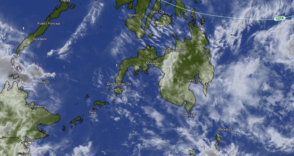
In its regional weather forecast issued at 5:00 a.m. on November 14, PAGASA’s Mindanao Regional Services Division (MINPRSD) said Northern Mindanao, Caraga, SOCCSKSARGEN, Davao Region, and the Bangsamoro Autonomous Region in Muslim Mindanao (BARMM) will experience cloudy skies with scattered rain showers and thunderstorms throughout the forecast period, which runs until 5:00 a.m. on November 15.
The weather agency warned that moderate to, at times, heavy rainfall could trigger flash floods and landslides, particularly in areas vulnerable to flooding and rain-induced slope failures.
SPONSORED LINK: https://lightlypowerfulgourmet.com/u9i107dsea?key=63025114fa6eb96108de24ad21ec0671
Meanwhile, the Zamboanga Peninsula and other parts of Mindanao are expected to have partly cloudy to cloudy skies, with isolated rain showers or thunderstorms also associated with the Easterlies. PAGASA cautioned that severe thunderstorms could still generate enough rainfall to cause flash floods or landslides in affected communities.
Rain and thunderstorms expected across major regions
In Northern Mindanao, the provinces of Bukidnon, Camiguin, Lanao del Norte, Misamis Occidental, and Misamis Oriental are forecast to experience cloudy skies with rain showers and thunderstorms. Temperatures in these areas are expected to range from 19°C to 30°C during the initial forecast period, with daytime highs reaching 32°C on Saturday.
Across Caraga, Agusan del Norte, Agusan del Sur, Surigao del Norte, Surigao del Sur, and Dinagat Islands are likewise expected to experience cloudy conditions with rain showers and thunderstorms. Temperatures are forecast to reach as high as 34°C in parts of the region.
The Davao Region will also remain under cloudy skies with rain showers and thunderstorms, including Metro Davao, Davao del Norte, Davao del Sur, Davao Oriental, Davao de Oro, and Davao Occidental.
Temperatures in the region are expected to range from 22°C to 32°C during the early forecast period, with maximum daytime temperatures reaching 34°C in Metro Davao and Davao del Norte. Davao Oriental is forecast to have temperatures between 22°C and 29°C initially, rising to a high of 31°C during the succeeding period.
In SOCCSKSARGEN, North Cotabato, South Cotabato, Sultan Kudarat, and Sarangani will experience cloudy skies with rain showers and thunderstorms during the initial forecast period. Conditions may become partly cloudy to at times cloudy in parts of the region during the daytime, although rain showers and thunderstorms will remain possible.
Temperatures across SOCCSKSARGEN are expected to range from 21°C to 31°C initially, with daytime highs reaching 33°C.
The BARMM provinces and areas, including Cotabato City, Basilan, Lanao del Sur, Sulu, Tawi-Tawi, Maguindanao del Norte, and Maguindanao del Sur, are also forecast to experience cloudy skies with rain showers and thunderstorms. Some areas may see partly cloudy to at times cloudy conditions during the daytime, but isolated rain showers and thunderstorms will remain possible.
Temperatures across the region are expected to reach 35°C in Maguindanao del Norte and Maguindanao del Sur.
Zamboanga Peninsula to experience isolated rain showers
Unlike the other major regions, Zamboanga City, Zamboanga del Norte, Zamboanga del Sur, Zamboanga Sibugay, and Isabela City are forecast to experience partly cloudy skies to at times cloudy conditions, with isolated rain showers or thunderstorms.
Temperatures in the peninsula are expected to range from 24°C to 32°C during the initial forecast period, with daytime highs reaching 35°C in Zamboanga City.
Despite the generally less widespread rainfall forecast for the peninsula, thunderstorms may still develop and bring sudden downpours in localized areas.
Light to moderate winds, generally slight to moderate seas
PAGASA said light to moderate winds from the east to northeast will prevail across Mindanao during the forecast period.
Coastal waters are expected to range from slight to moderate, with wave heights estimated at 0.6 to 2.5 meters. However, moderate sea conditions are forecast in several coastal areas, particularly parts of the Davao Region and Caraga.
The prevailing wind and sea conditions may still affect small fishing vessels and other maritime activities, particularly during periods of thunderstorms and locally worsening weather.
Residents urged to remain alert for flooding and landslides
With scattered rains and thunderstorms expected across much of Mindanao, residents, particularly those living near rivers, creeks, low-lying communities, and landslide-prone slopes, are advised to remain alert to changing weather conditions.
Communities should monitor rainfall conditions and local advisories, especially when moderate to heavy rains persist over the same areas. Sudden rises in river levels, overflowing waterways, and unstable slopes may pose risks even in locations that do not experience continuous rainfall.
Motorists are also advised to exercise caution on roads affected by heavy rain, reduced visibility, and possible flooding.
PAGASA emphasized that the regional forecast covers conditions from 5:00 a.m. on November 14 until 5:00 a.m. on November 15. Residents are encouraged to monitor succeeding weather bulletins and advisories for updates.
For additional weather information, the public may visit PAGASA’s official website at bagong.pagasa.dost.gov.ph or contact the agency through its telephone numbers 8922-1992 and 8927-1335.
Source: PAGASA Mindanao Regional Services Division (MINPRSD), Regional Weather Forecast issued November 14, 2026, at 5:00 a.m.