
MINDANAO — Most parts of Mindanao are expected to experience partly cloudy to cloudy skies with isolated rainshowers or localized thunderstorms on Sunday, September 6, with the Philippine Atmospheric, Geophysical and Astronomical Services Administration (PAGASA) warning that severe thunderstorms could trigger flash floods and landslides in vulnerable areas.
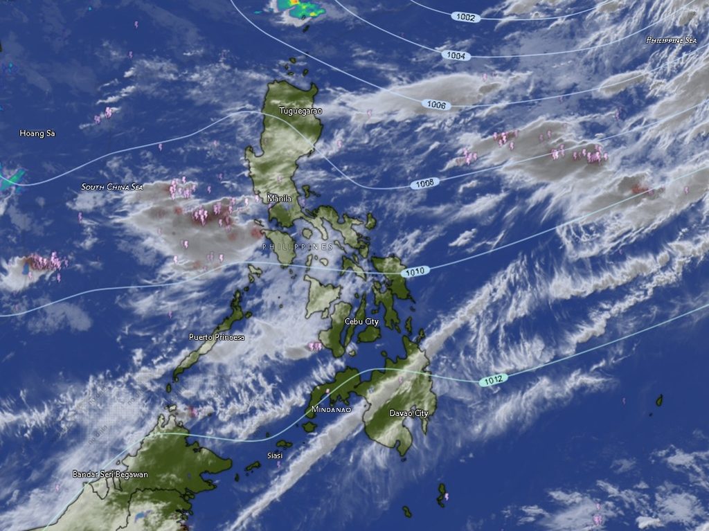
The regional weather forecast for Mindanao, issued at 5:00 a.m. Sunday and valid until 5:00 a.m. Monday, calls for generally light to moderate winds from the south to southwest. Coastal waters across the region are expected to range from slight to moderate, with wave heights of about 0.6 to 2.1 meters.
PAGASA’s forecast indicates that rainshowers or thunderstorms may occur across much of the region, although weather conditions may vary from partly cloudy to at times cloudy throughout the day.
The weather agency specifically warned of the possibility of flash floods and landslides due to severe thunderstorms, underscoring the need for residents in flood-prone, landslide-prone and low-lying communities to remain alert, particularly when thunderstorms bring intense rainfall over a short period.
Western Mindanao
In Zamboanga City and the provinces of Zamboanga del Norte, Zamboanga del Sur and Zamboanga Sibugay, partly cloudy to at times cloudy skies are forecast, with rainshowers or thunderstorms possible during both the daytime and nighttime periods.
Winds are expected to remain light to moderate from the south to southwest, while coastal waters will be slight to moderate.
Temperatures in Zamboanga City are forecast at 25°C to 35°C during the daytime, easing to 26°C to 34°C overnight. Zamboanga del Norte is likewise expected to reach 25°C to 35°C, while Zamboanga del Sur could see temperatures between 23°C and 33°C.
Zamboanga Sibugay is forecast to experience temperatures of 24°C to 34°C during the day and 25°C to 33°C at night.
Isabela City is expected to have similar conditions, with partly cloudy to at times cloudy skies and chances of rainshowers or thunderstorms. Temperatures could reach 26°C to 35°C during the day and 26°C to 34°C overnight.
Northern Mindanao
Across Bukidnon, partly cloudy to at times cloudy skies with rainshowers or thunderstorms are expected. Temperatures are forecast between 20°C and 32°C during the day and 21°C to 30°C overnight.
Camiguin may remain partly cloudy during the day, although rainshowers or thunderstorms could develop later. Temperatures are expected to range from 26°C to 36°C during the daytime and 27°C to 35°C at night.
Similar conditions are forecast in Lanao del Norte, Misamis Occidental and Misamis Oriental, with rainshowers or thunderstorms possible during both forecast periods. Daytime temperatures could reach 34°C to 35°C, depending on the province, before easing slightly overnight.
Davao Region
The Davao Region is also expected to remain vulnerable to rainshowers and thunderstorms throughout the forecast period.
In Metro Davao, partly cloudy to at times cloudy skies with rainshowers or thunderstorms are expected, accompanied by moderate south to southwest winds and moderate coastal conditions. Temperatures are forecast at 26°C to 33°C during the day and 26°C to 32°C overnight.
Davao del Norte may experience temperatures between 24°C and 33°C, while Davao del Sur is forecast to reach 26°C to 33°C during the daytime. Both areas are expected to have moderate winds from the south to southwest and moderate coastal waters.
Davao Oriental is forecast to have partly cloudy to at times cloudy skies with rainshowers or thunderstorms, with temperatures ranging from 25°C to 34°C during the day and 26°C to 33°C overnight.
Meanwhile, Davao de Oro could see daytime temperatures of 23°C to 35°C, while Davao Occidental is expected to range from 23°C to 31°C.
SOCCSKSARGEN
In North Cotabato, partly cloudy to at times cloudy skies with rainshowers or thunderstorms are forecast. Temperatures could climb from 23°C to 35°C during the day before easing to 24°C to 33°C overnight.
South Cotabato is expected to experience temperatures of 23°C to 33°C, while Sultan Kudarat could reach 24°C to 35°C.
Sarangani is forecast to remain partly cloudy to at times cloudy, with rainshowers or thunderstorms possible. Temperatures are expected to range from 27°C to 31°C during the daytime and 27°C to 29°C at night. Winds in Sarangani are forecast to be moderate from the south to southwest, with moderate coastal waters.
Caraga
Rainshowers or thunderstorms are likewise expected across Caraga, including Agusan del Norte, Agusan del Sur, Surigao del Norte, Surigao del Sur and the Dinagat Islands.
Agusan del Norte could experience temperatures ranging from 25°C to 36°C during the day, while Agusan del Sur is forecast at 23°C to 35°C.
The warmest daytime temperatures in the Caraga forecast could reach 36°C in both Agusan del Norte and Surigao del Norte. Surigao del Norte is expected to range from 27°C to 36°C, with temperatures falling to 28°C to 35°C overnight.
Surigao del Sur could reach 25°C to 34°C, while the Dinagat Islands may see 27°C to 35°C during the day. Both areas are forecast to have moderate south to southwest winds and moderate coastal conditions.
BARMM
The forecast also covers several areas of the Bangsamoro Autonomous Region in Muslim Mindanao (BARMM).
In Cotabato City, partly cloudy to at times cloudy skies with rainshowers or thunderstorms are expected, with temperatures of 24°C to 34°C during the day and 25°C to 33°C overnight.
Basilan is forecast to experience temperatures between 26°C and 35°C, while Lanao del Sur could see considerably cooler conditions, with temperatures ranging from 20°C to 30°C during the day and 21°C to 28°C at night.
In the island provinces, Sulu is forecast to have temperatures of 25°C to 33°C, while Tawi-Tawi could reach 27°C to 32°C during the day. Both areas may experience rainshowers or thunderstorms during the forecast period.
Maguindanao del Norte is expected to experience temperatures of 25°C to 34°C, while Maguindanao del Sur could reach 25°C to 35°C during the daytime. Both provinces may experience rainshowers or thunderstorms, with light to moderate winds from the south to southwest.
Tropical Storm Krovnh Outside PAR
PAGASA also reported Tropical Storm Krovnh (2624), formerly known as “Pilandok,” outside the Philippine Area of Responsibility as of 3:00 a.m. Sunday.
The storm was located approximately 875 kilometers northeast of extreme Northern Luzon, at coordinates 25.5°N, 128.7°E, with maximum sustained winds of 65 kilometers per hour near the center and gustiness of up to 80 kph.
Krovnh was moving east-southeastward at 10 kph at the time of the forecast.
The regional forecast does not indicate that the tropical storm is directly affecting Mindanao at this time. The principal weather concern for Mindanao remains the possibility of isolated rainshowers and localized thunderstorms, particularly severe thunderstorms capable of producing sudden heavy rainfall.
Residents Urged to Stay Alert
With thunderstorms possible across virtually all parts of Mindanao, residents are advised to monitor local weather conditions and official advisories, particularly those living near rivers, steep slopes, drainage channels and other areas vulnerable to flooding or landslides.
Motorists and commuters should also exercise caution when thunderstorms develop, as sudden heavy rainfall can quickly reduce visibility and cause hazardous road conditions.
For coastal communities, fishers and small boat operators, PAGASA’s forecast of slight to moderate seas and south to southwest winds should likewise be taken into account when planning activities at sea.
The forecast is valid from 5:00 a.m. Sunday, September 6, until 5:00 a.m. Monday, September 7, 2026, according to PAGASA’s Mindanao Regional Weather Forecast issued by the agency’s Mindanao station in El Salvador City, Misamis Oriental.