
DAVAO CITY – The southwest monsoon (Habagat) continues to affect Mindanao, bringing widespread rains and thunderstorms across much of the island, prompting the Philippine Atmospheric, Geophysical and Astronomical Services Administration (PAGASA) to warn residents in several regions of possible flash floods and landslides due to moderate to at times heavy rainfall.
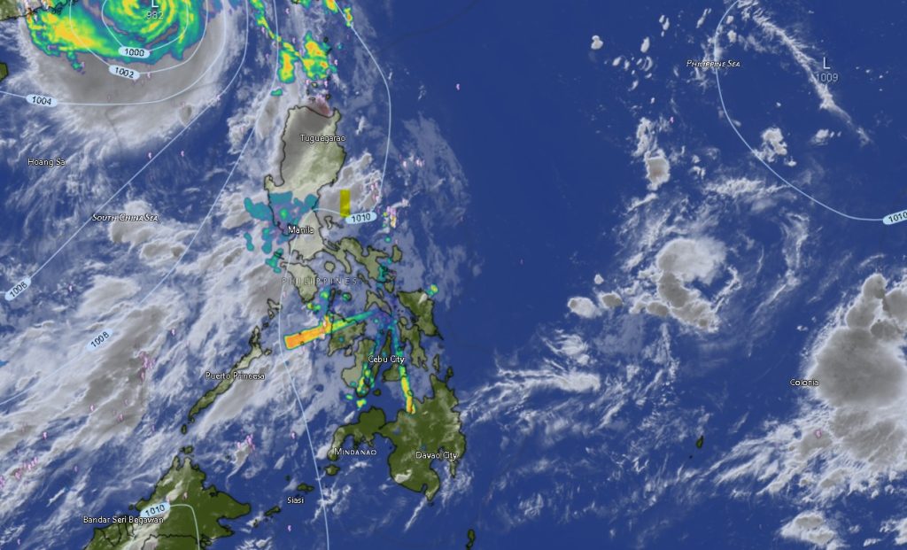
In its Regional Weather Forecast for the Mindanao Regional Services Division (MINPRSD), issued at 5:00 a.m. on Sunday, July 26, 2026, PAGASA said the weather system will remain the dominant weather disturbance affecting Mindanao until at least 5:00 a.m. Monday.
The weather bureau said Zamboanga Peninsula, the Bangsamoro Autonomous Region in Muslim Mindanao (BARMM), Northern Mindanao, and Caraga Region will experience cloudy skies with scattered rains and thunderstorms throughout the forecast period as the southwest monsoon continues to enhance moisture over the island.
PAGASA warned that these areas face an increased risk of flash floods and landslides, particularly in low-lying communities, flood-prone areas, and mountainous terrain, due to prolonged periods of moderate to occasionally heavy rainfall.
Meanwhile, the Davao Region and SOCCSKSARGEN are expected to have partly cloudy to cloudy skies with isolated rain showers and thunderstorms also associated with the southwest monsoon. While rainfall in these areas is expected to be less widespread, localized thunderstorms could still trigger flash floods and landslides, especially during intense downpours.
The weather bureau advised residents to remain vigilant, particularly during afternoon and evening thunderstorms, which may produce heavy rain, strong winds, lightning, and reduced visibility.
Across Mindanao, light to moderate winds blowing from the south to southwest will prevail, while coastal waters are expected to remain slight to moderate, with wave heights ranging from 0.6 to 1.8 meters, making sea conditions generally manageable for most small vessels. However, PAGASA urged fishermen and operators of small boats to exercise caution during thunderstorms, as weather conditions may deteriorate rapidly.
Regions under greater rainfall threat
Among the areas expected to receive the heaviest rainfall are the Zamboanga Peninsula, including Zamboanga City, Zamboanga del Norte, Zamboanga del Sur, Zamboanga Sibugay, and Isabela City, where cloudy skies with frequent rain showers and thunderstorms are forecast throughout the day.
Similar weather conditions are expected in Northern Mindanao, covering Bukidnon, Camiguin, Lanao del Norte, Misamis Occidental, and Misamis Oriental, where cloudy skies and intermittent rains may persist.
In BARMM, provinces including Basilan, Lanao del Sur, Sulu, Tawi-Tawi, Maguindanao del Norte, Maguindanao del Sur, and Cotabato City are likewise forecast to experience cloudy skies with scattered rains and thunderstorms brought by the southwest monsoon.
The Caraga Region, particularly Agusan del Norte, Agusan del Sur, Surigao del Norte, Surigao del Sur, and Dinagat Islands, is also expected to receive frequent rainfall, with some provinces transitioning from partly cloudy conditions to overcast skies accompanied by thunderstorms.
Meanwhile, Davao Region provinces—including Davao City, Davao del Norte, Davao del Sur, Davao Oriental, Davao Occidental, and Davao de Oro—are forecast to have partly cloudy to cloudy skies with isolated rain showers and thunderstorms. Temperatures across the region are expected to range between 22°C and 33°C, depending on location.
Likewise, SOCCSKSARGEN, comprising North Cotabato, South Cotabato, Sultan Kudarat, and Sarangani, will continue to experience warm weather interrupted by isolated thunderstorms, with daytime temperatures reaching as high as 33°C.
Typhoon Noul remains outside PAR
PAGASA also reported that Typhoon Noul (2612) remains outside the Philippine Area of Responsibility (PAR) and is not directly affecting the country.
As of 3:00 p.m. Saturday, the typhoon was located approximately 560 kilometers west of Itbayat, Batanes, packing maximum sustained winds of 130 kilometers per hour, gusts of up to 160 kilometers per hour, and moving west-northwestward at 30 kilometers per hour.
Although Noul remains outside PAR, PAGASA said the southwest monsoon will continue to be the primary weather system influencing conditions over Mindanao.
Authorities continue to advise the public to closely monitor official weather bulletins, avoid crossing swollen rivers and flooded roads, and remain alert for possible flooding and landslides, especially in areas with saturated soil and communities located near rivers and mountain slopes.