
Mindanao, Philippines – July 27, 2026 – Residents across Mindanao should prepare for another day of unstable weather as the Philippine Atmospheric, Geophysical and Astronomical Services Administration (PAGASA) Mindanao Regional Services Division (MINPRSD) forecasts localized thunderstorms across the island from 5:00 a.m. Monday, July 27, until 5:00 a.m. Tuesday, July 28.
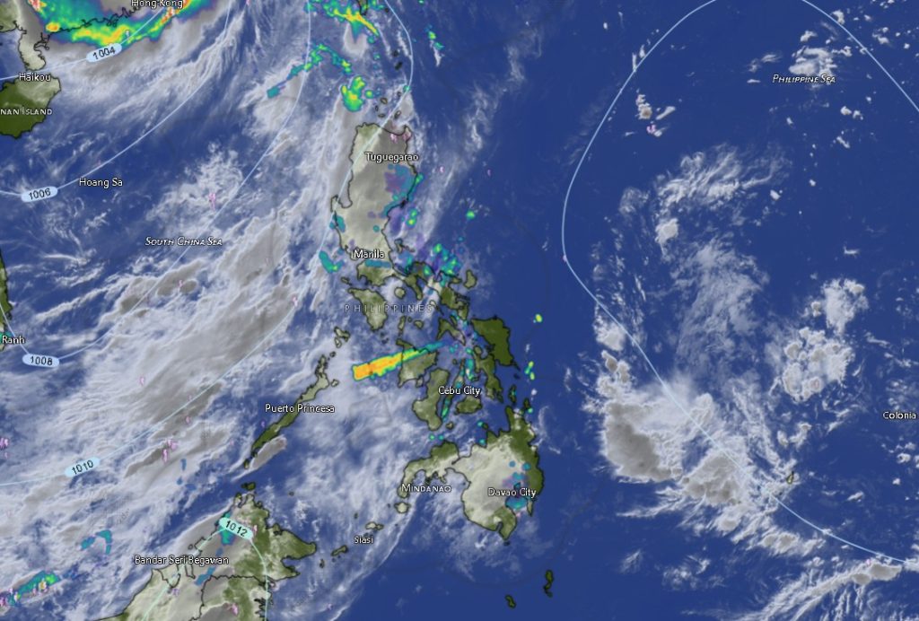
According to PAGASA’s latest regional weather forecast issued at 5:00 a.m., partly cloudy to cloudy skies with isolated rainshowers and localized thunderstorms will prevail throughout Mindanao. While much of the day may begin with fair weather, weather authorities warned that thunderstorms could rapidly develop, bringing heavy rainfall capable of triggering flash floods and landslides, particularly in low-lying communities, flood-prone areas, and mountainous terrain.
PAGASA advised the public to remain vigilant, especially during the afternoon and evening hours when localized thunderstorms are more likely to intensify.
Entire Mindanao Under Thunderstorm Threat
The forecast covers all six administrative regions of Mindanao, including the Zamboanga Peninsula, Northern Mindanao, Davao Region, SOCCSKSARGEN, Caraga Region, and the Bangsamoro Autonomous Region in Muslim Mindanao (BARMM).
Across the Zamboanga Peninsula, including Zamboanga City, Zamboanga del Norte, Zamboanga del Sur, Zamboanga Sibugay, and Isabela City, residents can expect partly cloudy skies becoming cloudy at times with rainshowers or thunderstorms. Moderate southeast to southwest winds will prevail over coastal waters, producing moderate sea conditions. Temperatures are expected to range from 25°C to 33°C.
In Northern Mindanao, the provinces of Bukidnon, Camiguin, Lanao del Norte, Misamis Occidental, and Misamis Oriental will also experience isolated rainshowers and thunderstorms. Winds will generally remain light from the southeast to southwest, while coastal waters are expected to remain slight. Temperatures across the region will range from 19°C in the highlands of Bukidnon to as high as 32°C in coastal provinces.
The Davao Region, including Metro Davao, Davao del Norte, Davao del Sur, Davao Oriental, Davao de Oro, and Davao Occidental, is likewise forecast to experience partly cloudy to cloudy skies with intermittent rainshowers and thunderstorms. Light to moderate winds and slight to moderate coastal conditions are expected, with temperatures ranging between 23°C and 32°C.
Communities in SOCCSKSARGEN, covering North Cotabato, South Cotabato, Sultan Kudarat, and Sarangani, should also anticipate similar weather conditions. Temperatures are forecast to range from 24°C to 32°C, while coastal waters along Sarangani will remain slight to moderate.
In the Caraga Region, including Agusan del Norte, Agusan del Sur, Surigao del Norte, Surigao del Sur, and Dinagat Islands, localized thunderstorms may develop throughout the day. Daytime temperatures could climb as high as 34°C in parts of Agusan del Norte and Surigao del Sur, increasing atmospheric instability and the likelihood of afternoon thunderstorms.
Meanwhile, the BARMM provinces of Basilan, Lanao del Sur, Maguindanao del Norte, Maguindanao del Sur, Sulu, Tawi-Tawi, and Cotabato City will also experience partly cloudy skies becoming cloudy with isolated rainshowers or thunderstorms. Coastal waters over Basilan, Sulu, and Tawi-Tawi will remain moderate due to moderate southeast to southwest winds, while inland areas will experience lighter wind conditions. Temperatures across the region are forecast to range from 22°C in Lanao del Sur to 32°C in several lowland areas.
Marine Conditions Remain Favorable
Despite the widespread thunderstorm activity, sea conditions around Mindanao are expected to remain generally manageable.
Coastal waters in Northern Mindanao will remain slight, with wave heights ranging from 0.6 to 1.2 meters, while much of the Zamboanga Peninsula and island provinces in western BARMM will experience moderate seas of up to 1.5 meters due to moderate winds.
However, PAGASA reminded fishermen and operators of small sea vessels to exercise caution whenever thunderstorms develop, as strong gusts and rougher waves may occur suddenly.
Public Advised to Stay Alert
Although no tropical cyclone is directly affecting Mindanao, localized thunderstorms remain capable of producing intense rainfall within short periods. PAGASA urged local government units, disaster risk reduction offices, motorists, farmers, fisherfolk, and the general public to closely monitor weather updates throughout the day.
Residents living near rivers, creeks, steep slopes, and areas with a history of flooding or landslides are encouraged to remain alert for possible evacuation advisories should heavy rains persist.
Motorists are likewise advised to drive cautiously during heavy downpours due to reduced visibility and slippery road conditions.
PAGASA continues to monitor weather conditions across Mindanao and advises the public to follow official forecasts and warnings for the latest updates.