
DAVAO CITY – Large parts of Mindanao are expected to experience another day of unsettled weather as the trough of a Low Pressure Area (LPA) continues to affect the island, bringing cloudy skies, scattered rains, and thunderstorms, according to the Philippine Atmospheric, Geophysical and Astronomical Services Administration (PAGASA) Mindanao Regional Services Division (MINPRSD).
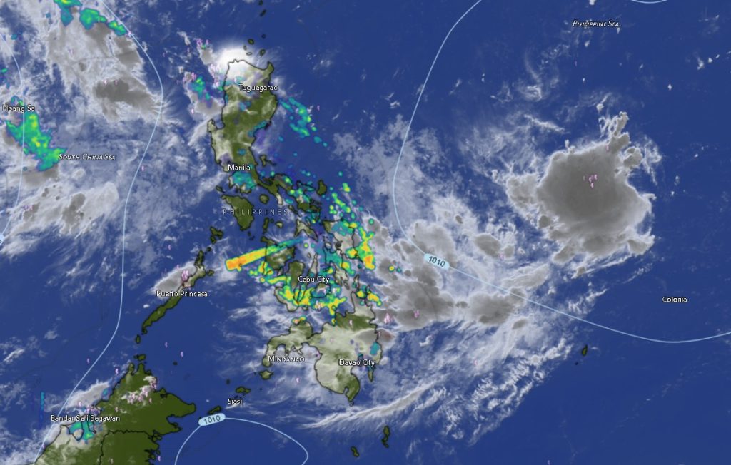
In its 5:00 a.m. Regional Weather Forecast issued on Friday, July 31, 2026, PAGASA said the forecast remains valid until 5:00 a.m. on Saturday, August 1.
The weather bureau identified Northern Mindanao, Caraga Region, and the entire Davao Region as the areas expected to receive the heaviest rainfall due to the trough of the LPA.
PAGASA warned that moderate to at times heavy rains may trigger flash floods and landslides, particularly in flood-prone communities, mountainous areas, and locations that have already experienced prolonged rainfall in recent days.
Northern Mindanao Under Rainy Skies
Residents in Bukidnon, Camiguin, Lanao del Norte, Misamis Occidental, and Misamis Oriental should expect cloudy skies with scattered rainshowers and thunderstorms throughout the forecast period.
Daytime temperatures in the region are expected to range between 21°C and 33°C, with Bukidnon remaining the coolest province at 21°C to 31°C, while coastal provinces will experience slightly warmer conditions.
Authorities are urging motorists traveling through mountain highways, especially those crossing Bukidnon and Lanao del Norte, to exercise caution due to the possibility of reduced visibility, slippery roads, and isolated landslides.
Davao Region Faces Continued Wet Weather
The entire Davao Region is likewise forecast to experience cloudy skies with scattered rains and thunderstorms.
The affected areas include:
- Metro Davao
- Davao del Norte
- Davao del Sur
- Davao Oriental
- Davao de Oro
- Davao Occidental
Temperatures across the region will range from 23°C to 34°C.
Among the warmest areas expected on Friday are Davao de Oro, Davao del Norte, and Davao Oriental, where daytime temperatures may climb to 33°C to 34°C despite the rainy weather.
PAGASA emphasized that intermittent heavy downpours could still occur even during periods of sunshine, a common weather pattern associated with tropical disturbances and localized thunderstorms.
Caraga Region Also Under LPA Influence
The trough of the LPA will likewise bring cloudy skies with scattered rains and thunderstorms over the entire Caraga Region, including:
- Agusan del Norte
- Agusan del Sur
- Surigao del Norte
- Surigao del Sur
- Dinagat Islands
Temperatures are expected to range between 23°C and 34°C.
Residents near rivers, creeks, and low-lying communities are advised to remain alert as continuous rainfall may lead to rapid rises in water levels.
Fairer Weather for the Rest of Mindanao
Meanwhile, the rest of Mindanao—including SOCCSKSARGEN, BARMM, and the Zamboanga Peninsula—will generally experience partly cloudy to cloudy skies with isolated rainshowers and thunderstorms due to localized thunderstorm activity.
While these areas are not directly under the influence of the LPA trough, PAGASA cautioned that isolated thunderstorms could still produce intense rainfall capable of causing localized flash floods and landslides.
The forecast covers:
SOCCSKSARGEN
- North Cotabato
- South Cotabato
- Sultan Kudarat
- Sarangani
BARMM
- Cotabato City
- Basilan
- Lanao del Sur
- Maguindanao del Norte
- Maguindanao del Sur
- Sulu
- Tawi-Tawi
Zamboanga Peninsula
- Zamboanga City
- Zamboanga del Norte
- Zamboanga del Sur
- Zamboanga Sibugay
- Isabela City
Temperatures in these areas are expected to range from 20°C to 34°C, with Lanao del Sur recording the coolest conditions at 20°C to 30°C.
Sea Conditions Favorable for Small Vessels
Across Mindanao, winds will be light to moderate, blowing from the south to southwest.
Coastal waters will remain slight to moderate, with wave heights ranging from 0.6 to 2.1 meters, making sea travel generally manageable. However, PAGASA advised operators of small fishing boats and other small sea vessels to remain cautious whenever thunderstorms develop, as these may generate sudden strong winds and rougher seas.
Public Advised to Stay Alert
PAGASA reminded the public, particularly those living in flood-prone, low-lying, and landslide-susceptible areas, to closely monitor official weather advisories and heed instructions from local disaster risk reduction and management offices.
Residents are encouraged to prepare for possible heavy rainfall, secure loose outdoor belongings, avoid crossing swollen rivers, and remain vigilant as localized thunderstorms may rapidly intensify and bring dangerous weather conditions even outside the areas directly affected by the LPA.
The weather bureau continues to monitor the trough of the Low Pressure Area and advises the public to stay updated through PAGASA’s official bulletins and local government advisories as weather conditions may change throughout the day.