April 8, 2026
Intermittent rains and thunderstorms are expected to affect large parts of Mindanao over the next 24 hours, as forecasters from the Philippine Atmospheric, Geophysical and Astronomical Services Administration warned of localized thunderstorms that could trigger flash floods and landslides in vulnerable areas.
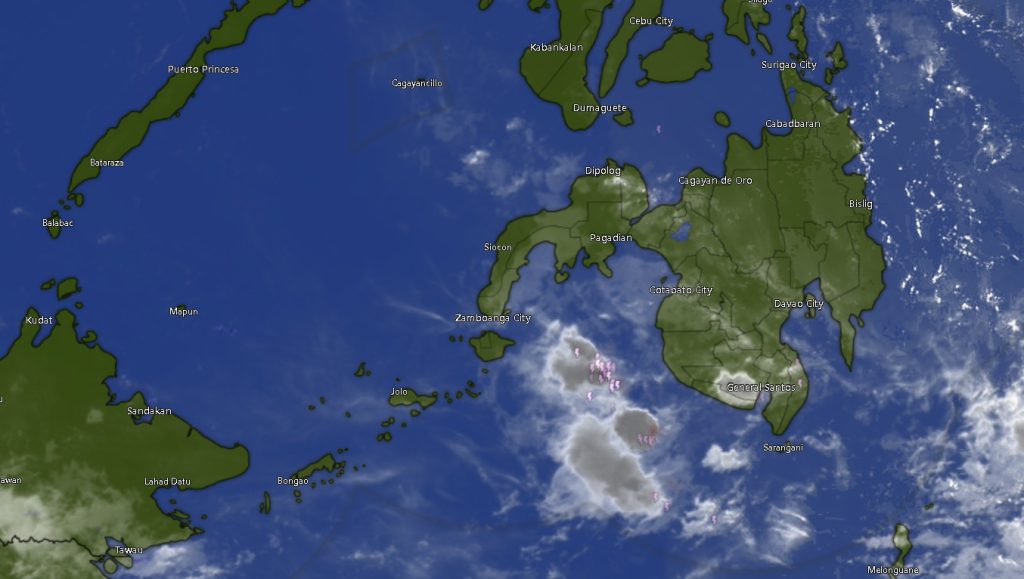
In its 5:00 a.m. regional forecast, PAGASA’s Mindanao Regional Services Division (MINPRSD) said the entire island will experience partly cloudy to cloudy skies with isolated rain showers or thunderstorms from April 8 to early April 9. These weather disturbances are driven by localized convective activity, common during warm and humid conditions.
Authorities cautioned that while rains may be brief, they could intensify rapidly, posing risks especially in low-lying communities and landslide-prone المناطق.
Widespread Rainfall Across Regions
Across the Zamboanga Peninsula — including Zamboanga City, Zamboanga del Norte, Zamboanga del Sur, Zamboanga Sibugay, and Isabela City — temperatures will range between 23°C and 34°C. Residents can expect occasional thunderstorms throughout the day and night, accompanied by light to moderate winds from the east to northeast and slight to moderate coastal conditions.
In Northern Mindanao, including Bukidnon, Camiguin, Lanao del Norte, Misamis Occidental, and Misamis Oriental, similar weather patterns will prevail. Temperatures will hover between 21°C and 34°C, with inland areas like Bukidnon experiencing slightly cooler conditions.
The Davao Region, including Metro Davao, Davao del Norte, Davao del Sur, Davao Oriental, Davao de Oro, and Davao Occidental, will see daytime highs reaching up to 35°C. Thunderstorms may develop in the afternoon and evening, potentially bringing heavy downpours.
Thunderstorms Extend to SOCCSKSARGEN and Caraga
In the SOCCSKSARGEN region — covering North Cotabato, South Cotabato, Sultan Kudarat, and Sarangani — temperatures will range from 24°C to 35°C, with similar thunderstorm activity expected throughout the forecast period.
Meanwhile, the Caraga Region — including Agusan del Norte, Agusan del Sur, Surigao del Norte, Surigao del Sur, and Dinagat Islands — will also experience scattered rain showers and thunderstorms, with temperatures ranging between 24°C and 34°C.
BARMM Areas Also Affected
The Bangsamoro Autonomous Region in Muslim Mindanao will not be spared from unstable weather conditions. Areas including Cotabato City, Basilan, Lanao del Sur, Sulu, Tawi-Tawi, Maguindanao del Norte, and Maguindanao del Sur will experience partly cloudy to cloudy skies with intermittent thunderstorms and temperatures ranging from 22°C to 35°C.
Sea and Wind Conditions
Across Mindanao, winds will generally be light to moderate, blowing from the east to northeast. Coastal waters will remain slight to moderate, with wave heights ranging from 0.4 to 1.5 meters — conditions generally safe for small sea vessels, though caution is advised during thunderstorms.
Public Advisory
PAGASA urged residents to remain vigilant, particularly during afternoon and evening hours when thunderstorms are more likely to intensify. Communities in flood-prone and mountainous areas are advised to monitor local weather updates and take necessary precautions.
With localized thunderstorms continuing to dominate the weather pattern, authorities emphasized the importance of preparedness as sudden heavy rains may lead to rapid flooding and landslides across parts of Mindanao.