COTABATO CITY, Philippines — Residents across Mindanao can expect partly cloudy to cloudy skies with isolated rain showers and thunderstorms over the next 24 hours as localized thunderstorms continue to affect various parts of the island, according to the latest regional weather forecast issued by the Philippine Atmospheric, Geophysical and Astronomical Services Administration (PAGASA) on Saturday morning.
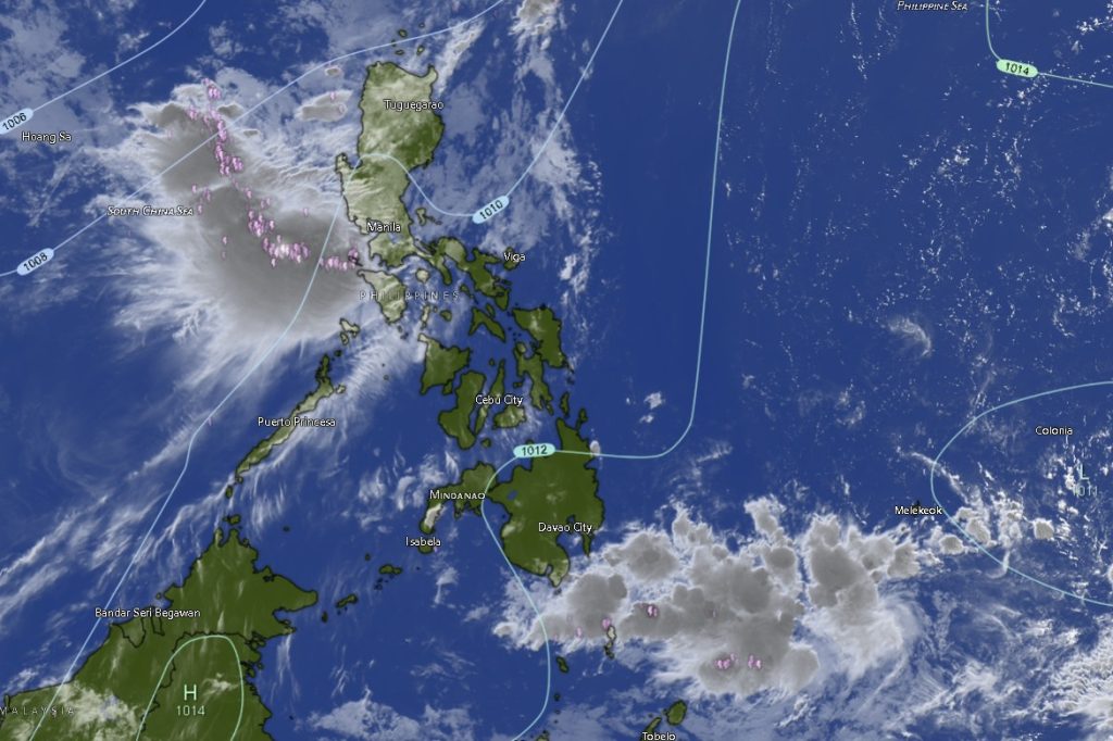
In its 5:00 a.m. weather bulletin, PAGASA reported that Tropical Depression “Ester” was located approximately 350 kilometers north-northeast of Itbayat, Batanes as of 3:00 a.m. The weather disturbance was estimated at coordinates 23.8°N, 122.8°E, carrying maximum sustained winds of 45 kilometers per hour and gusts reaching up to 55 kilometers per hour while moving east-northeastward at 15 kilometers per hour.
Despite the presence of the tropical depression in the northern part of the country, PAGASA said the weather system is not expected to directly affect Mindanao. However, localized thunderstorms remain the dominant weather system influencing conditions across the island.
Forecasters warned that while most areas will experience generally fair weather, isolated thunderstorms could develop, particularly during the afternoon and evening hours. These weather disturbances may trigger sudden heavy downpours capable of causing flash floods and landslides, especially in low-lying, flood-prone, and mountainous areas.
“Mindanao will experience partly cloudy to cloudy skies with isolated rain showers or thunderstorms caused by localized thunderstorms. Possible flash floods or landslides may occur during severe thunderstorms,” PAGASA stated.
Winds throughout Mindanao are expected to remain light to moderate, coming from the south to southwest. Coastal waters will be slight to moderate, with wave heights ranging from 0.6 to 1.8 meters, allowing generally safe sea travel for small fishing vessels and inter-island boats, although mariners are advised to remain alert for sudden squalls associated with thunderstorms.
Zamboanga Peninsula
The entire Zamboanga Peninsula, including Zamboanga City, Zamboanga del Norte, Zamboanga del Sur, Zamboanga Sibugay, and Isabela City, will experience similar weather conditions characterized by partly cloudy to cloudy skies with intermittent rain showers and thunderstorms.
Daytime temperatures are expected to range from 25°C to 35°C, with Zamboanga City forecast to experience the highest daytime temperature of up to 35°C. Nighttime temperatures are expected to remain between 25°C and 34°C.
Northern Mindanao
In Northern Mindanao, including Bukidnon, Camiguin, Lanao del Norte, Misamis Occidental, and Misamis Oriental, residents can also expect scattered thunderstorm activity throughout the day and night.
Bukidnon will record some of the coolest temperatures in the region, with lows of 19°C and highs reaching 31°C. Coastal provinces such as Camiguin, Misamis Occidental, and Misamis Oriental are forecast to experience temperatures ranging from 25°C to 33°C.
Davao Region
Across the Davao Region, including Metro Davao, Davao del Norte, Davao del Sur, Davao Oriental, Davao de Oro, and Davao Occidental, localized thunderstorms remain likely throughout the forecast period.
Temperatures across the region are expected to range between 22°C and 33°C. Davao del Norte and Davao de Oro may experience the warmest conditions, with daytime highs reaching 33°C.
Authorities advised residents to remain vigilant for localized flooding in urban areas and possible landslides in elevated terrain, particularly during periods of intense rainfall.
SOCCSKSARGEN
In Region 12 or SOCCSKSARGEN, which includes North Cotabato, South Cotabato, Sultan Kudarat, and Sarangani, weather conditions will remain generally favorable but with chances of isolated thunderstorms.
North Cotabato is expected to record one of the highest temperatures in Mindanao, reaching up to 34°C during the day. Other provinces in the region will see temperatures ranging from 24°C to 32°C.
Agricultural communities are expected to benefit from the intermittent rainfall, although farmers are encouraged to monitor weather advisories, particularly when conducting field activities.
Caraga Region
The Caraga Region, comprising Agusan del Norte, Agusan del Sur, Surigao del Norte, Surigao del Sur, and Dinagat Islands, will continue to experience partly cloudy to cloudy skies with occasional thunderstorms.
Agusan del Norte is forecast to be the hottest area in Mindanao, with temperatures potentially reaching 36°C during the day. Surigao del Norte, Surigao del Sur, and Dinagat Islands may also experience warm conditions, with temperatures climbing to between 34°C and 35°C.
The combination of high daytime temperatures and moisture in the atmosphere could contribute to the development of afternoon thunderstorms across the region.
BARMM Areas
In the Bangsamoro Autonomous Region in Muslim Mindanao (BARMM), including Cotabato City, Basilan, Lanao del Sur, Sulu, Tawi-Tawi, Maguindanao del Norte, and Maguindanao del Sur, weather conditions are expected to remain generally stable with occasional rain showers and thunderstorms.
Temperatures will range from 23°C to 34°C, with Cotabato City likely reaching 34°C during the daytime. Coastal conditions throughout BARMM remain slight to moderate, favorable for fishing and maritime activities, although fishermen are advised to exercise caution whenever thunderstorms develop.
Public Advisory
PAGASA urged the public to remain updated on the latest weather bulletins, particularly communities vulnerable to flooding and landslides. While Tropical Depression Ester remains far from Mindanao and poses no immediate threat to the island, localized thunderstorms can still produce heavy rainfall, lightning, and strong gusty winds over short periods.
Motorists, farmers, fishermen, and local disaster response units are advised to monitor weather developments and take necessary precautions against sudden weather changes, especially during afternoon and evening hours when thunderstorm activity is typically more pronounced.
The regional forecast remains valid from 5:00 a.m. Saturday, June 6, until 5:00 a.m. Sunday, June 7, 2026.