TUPI, South Cotabato — While towering peaks such as Mount Matutum and Mount Parker dominate the landscape of South Cotabato, a quieter but equally significant development is taking shape beneath the ground—one that could play a crucial role in protecting lives and communities across Mindanao from future geological hazards.
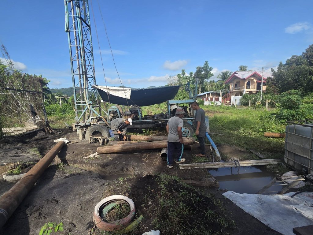
In Barangay Cr. Rubber, Tupi, construction is underway for a state-of-the-art borehole seismic station being established by the Philippine Institute of Volcanology and Seismology (PHIVOLCS) under the Department of Science and Technology (DOST). Another seismic monitoring station is simultaneously being built in Barangay Miasong, further strengthening the region’s capability to detect and monitor seismic activity.
Once operational, the facilities will become part of the country’s expanding earthquake and volcano monitoring network, providing critical data on the activity of two of Mindanao’s prominent volcanoes—Mount Matutum and Mount Parker—as well as recording ground shaking generated by earthquakes in Region XII and neighboring areas.
The project underscores the government’s continuing efforts to invest in science-based disaster risk reduction strategies in a region situated within one of the world’s most seismically active zones.
A Watchful Eye Beneath the Surface
Unlike conventional seismic monitoring stations, borehole seismic stations are designed to place highly sensitive instruments deep underground. This allows the equipment to capture clearer and more accurate seismic signals by minimizing surface noise caused by weather, human activities, and environmental disturbances.
The enhanced monitoring capability is expected to improve the detection of small earthquakes and subtle volcanic movements that may serve as early indicators of larger geological events.
For communities living near active and potentially active volcanoes, such data can be invaluable.
Mount Matutum, one of South Cotabato’s most iconic natural landmarks, rises more than 2,200 meters above sea level and is considered a potentially active volcano. Mount Parker, located nearby in the province of South Cotabato, is likewise known for its volcanic history and the scenic Lake Maughan that fills its crater.
Although neither volcano has shown recent signs of eruption, experts emphasize that continuous monitoring remains essential, as volcanic systems can remain dormant for extended periods before becoming active again.
The new seismic stations will provide PHIVOLCS scientists with real-time information necessary to evaluate changes in volcanic behavior and issue timely advisories should abnormal activity occur.
Investing in Prevention Rather Than Response
The construction of the monitoring facilities is being carried out through a collaboration between DOST-PHIVOLCS and the Local Government Unit of Tupi, led by Mayor Engr. Romeo Tamayo, CESO, who also serves as Chairperson of the Municipal Disaster Risk Reduction and Management Council (MDRRMC).
Local officials view the project as a significant investment in disaster preparedness, particularly as climate-related disasters and geological hazards continue to pose risks to communities across Mindanao.
The installation of seismic monitoring systems and early warning devices forms part of broader Disaster Risk Reduction and Management (DRRM) programs aimed at preventing disasters from becoming tragedies.
Rather than waiting for earthquakes, volcanic unrest, or other hazards to strike, the initiative focuses on strengthening the capacity of government agencies and local communities to anticipate risks and respond effectively.
Disaster management experts have long emphasized that timely information is among the most effective tools in reducing casualties and economic losses during emergencies.
Building a Safer Mindanao
The establishment of the new seismic stations comes as PHIVOLCS continues to modernize and expand its monitoring network nationwide. Advances in seismic technology have enabled scientists to gather increasingly precise information, improving hazard assessments and supporting more accurate early warning systems.
For Mindanao, which sits near several active fault systems and volcanic centers, the additional monitoring capability represents a major enhancement in regional disaster resilience.
Residents may never directly see the sophisticated instruments buried beneath the earth in Barangay Cr. Rubber and Barangay Miasong, but the information gathered by these stations could one day provide the critical seconds, minutes, or even days needed to prepare for potentially life-threatening events.
As construction progresses, the project serves as a reminder that disaster preparedness does not begin when the ground starts shaking or when a volcano emits ash. It begins long before—through planning, scientific research, infrastructure development, and sustained collaboration between national agencies and local governments.
In South Cotabato, that preparation is now being built from the ground up, creating a stronger shield against the natural hazards that have long shaped the landscape of Mindanao.