
Cloudy skies with scattered rains and thunderstorms are expected to affect parts of Mindanao on Monday, February 24, as the easterlies continue to influence weather conditions across the region, according to the Philippine Atmospheric, Geophysical and Astronomical Services Administration (PAGASA).
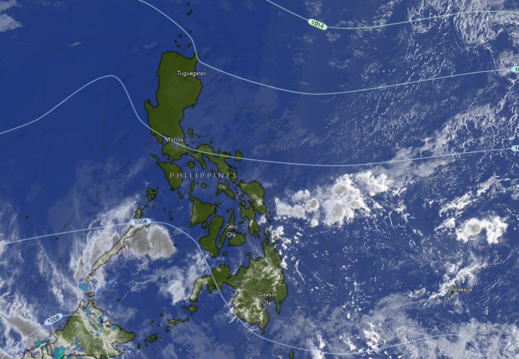
In its 5:00 a.m. regional weather forecast issued by the Mindanao Regional Services Division (MINPRSD), PAGASA said areas in the Zamboanga Peninsula and parts of the Bangsamoro region, particularly Basilan and Tawi-Tawi, will experience cloudy skies with scattered rain showers and thunderstorms throughout the day until early Tuesday morning.
Weather forecasters warned that moderate to occasionally heavy rains may trigger possible flash floods or landslides, especially in vulnerable and mountainous communities.
Zamboanga Peninsula Under Cloudy, Rainy Conditions
Residents in Zamboanga City, along with the provinces of Zamboanga del Norte, Zamboanga del Sur, Zamboanga Sibugay, and Isabela City, are expected to experience cloudy skies with rain showers and thunderstorms both during the daytime and nighttime periods.
Temperatures in these areas are forecast to range between 23°C and 32°C, with slightly cooler conditions overnight. Winds will remain light to moderate coming from the east to northeast, while coastal waters are expected to remain slight to moderate, with wave heights between 0.6 to 2.5 meters.
Basilan and Tawi-Tawi Also Facing Frequent Rains
In the Bangsamoro Autonomous Region in Muslim Mindanao, the provinces of Basilan and Tawi-Tawi are also forecast to experience cloudy skies with rain showers and thunderstorms throughout the forecast period. Temperatures in these island provinces are expected to range from 23°C to 30°C.
Authorities advised residents in low-lying and landslide-prone areas to remain alert as heavy rains may lead to sudden flooding or soil erosion.
Rest of Mindanao to See Isolated Rain Showers
Meanwhile, the rest of Mindanao will experience partly cloudy to cloudy skies with isolated rain showers or thunderstorms also caused by the easterlies.
In Northern Mindanao, including Bukidnon, Camiguin, Lanao del Norte, Misamis Occidental, and Misamis Oriental, temperatures are expected to range from 20°C to 32°C, with occasional thunderstorms possible.
Similar weather patterns are forecast in the Davao Region, covering Davao City, Davao del Norte, Davao del Sur, Davao Oriental, Davao de Oro, and Davao Occidental, where daytime temperatures could reach up to 32°C.
In the SOCCSKSARGEN area, including South Cotabato, Sultan Kudarat, Sarangani, and North Cotabato, partly cloudy to cloudy skies with possible rain showers and thunderstorms are also expected.
Caraga and Other BARMM Areas
The same weather system will also affect provinces in the Caraga Region such as Agusan del Norte, Agusan del Sur, Surigao del Norte, Surigao del Sur, and Dinagat Islands, where isolated thunderstorms may develop during the day and evening.
Other areas in BARMM including Cotabato City, Lanao del Sur, Sulu, Maguindanao del Norte, and Maguindanao del Sur will also experience partly cloudy to cloudy conditions with possible rain showers and thunderstorms.
Advisory to Residents and Fisherfolk
PAGASA advised the public to remain cautious, particularly in areas prone to flooding and landslides as thunderstorms may bring sudden heavy downpours. Fisherfolk and small sea vessels are also urged to monitor weather updates as coastal waters across Mindanao will remain slight to moderate.
The weather forecast is valid from 5:00 a.m. Monday, February 24, until 5:00 a.m. Tuesday, February 25, 2026, with authorities encouraging residents to stay updated through official PAGASA bulletins and local disaster risk reduction offices.