
MINDANAO — Most parts of Mindanao are expected to experience cloudy skies, scattered rainshowers, and thunderstorms on October 5, 2026, as the trough of Typhoon Choi-Wan continues to affect the region, according to the regional weather forecast issued by the Philippine Atmospheric, Geophysical and Astronomical Services Administration (PAGASA) Mindanao PRSD (MINPRSD).
The forecast, issued at 5:00 AM on October 5, 2026, covers the period from 5:00 AM until 5:00 PM the same day. It indicates generally cloudy conditions accompanied by rainshowers and thunderstorms across the provinces and areas covered by the regional forecast.
PAGASA warned that flash floods and landslides are possible, particularly in areas that receive moderate to at times heavy rainfall. Residents in flood-prone communities, landslide-susceptible areas, and those living near rivers and waterways are advised to remain alert to changing weather conditions.
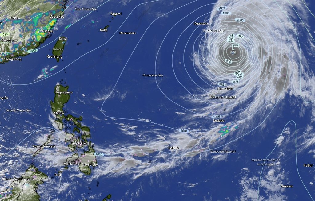
The weather disturbance affecting Mindanao is associated with the trough of Typhoon Choi-Wan, which remained outside the Philippine Area of Responsibility (PAR).
As of 3:00 PM on October 4, Typhoon Choi-Wan was located approximately 2,610 kilometers east of extreme Northern Luzon, near 23.0°N, 147.0°E. It had maximum sustained winds of 175 kilometers per hour near the center, with gustiness of up to 215 kilometers per hour, and was moving northward at 15 kilometers per hour.
Despite the typhoon’s distance from the country, its trough is contributing to unsettled weather over Mindanao, prompting the regional forecast for widespread cloudy conditions, rainshowers, and thunderstorms.
Rainy Conditions Across Mindanao
The forecast calls for cloudy skies with rainshowers and thunderstorms across the Zamboanga Peninsula, Northern Mindanao, Davao Region, SOCCSKSARGEN, Caraga, and parts of the Bangsamoro Autonomous Region in Muslim Mindanao (BARMM).
In the Zamboanga Peninsula, Zamboanga City is forecast to experience temperatures ranging from 26°C to 32°C, while Zamboanga del Norte could reach 34°C. Zamboanga del Sur is expected to range from 24°C to 32°C, while Zamboanga Sibugay may record 25°C to 31°C. Isabela City is forecast at 26°C to 31°C.
Across Northern Mindanao, Bukidnon is expected to have temperatures between 20°C and 32°C, while Camiguin may range from 26°C to 33°C. Lanao del Norte and Misamis Occidental are both forecast to reach up to 32°C, while Misamis Oriental could reach 33°C.
In the Davao Region, Metro Davao is expected to experience temperatures of 25°C to 32°C. Davao del Norte could reach 34°C, while Davao del Sur is forecast at 23°C to 31°C. Davao Oriental may range from 25°C to 31°C, Davao de Oro from 23°C to 35°C, and Davao Occidental from 24°C to 31°C.
For SOCCSKSARGEN, North Cotabato is forecast to reach 32°C, while South Cotabato and Sultan Kudarat could reach 29°C and 30°C, respectively. Sarangani is expected to range from 25°C to 31°C.
The Caraga Region will likewise remain generally cloudy with rainshowers and thunderstorms. Agusan del Norte could reach 34°C, while Agusan del Sur may climb to 35°C. Surigao del Norte is forecast at 25°C to 34°C, Surigao del Sur at 24°C to 36°C, and Dinagat Islands at 26°C to 34°C.
In BARMM, Cotabato City is forecast to reach 33°C, Basilan 30°C, Lanao del Sur 30°C, Sulu 32°C, Tawi-Tawi 32°C, Maguindanao del Norte 33°C, and Maguindanao del Sur 33°C.
Winds and Coastal Conditions
PAGASA forecasts light to moderate winds from the west to southwest across Mindanao.
Coastal waters in areas covered by the forecast are generally expected to remain slight to moderate, with wave heights of approximately 0.6 to 1.2 meters.
While these conditions are not expected to produce generally rough seas across the region, fishermen, small boat operators, and other coastal communities are advised to exercise caution, particularly during thunderstorms and periods of stronger winds.
Flood and Landslide Risk Remains
The possibility of moderate to at times heavy rains remains the primary weather-related concern. PAGASA specifically warned that such rainfall could trigger flash floods and landslides, especially in vulnerable areas.
Communities should monitor official weather updates and local government advisories, particularly when thunderstorms develop over or upstream of their areas.
Residents in low-lying and flood-prone communities are advised to avoid crossing swollen rivers and waterways, while those in areas with a history of landslides should remain vigilant for signs of slope instability during prolonged or heavy rainfall.
The public is also advised to take appropriate precautions during thunderstorms, including avoiding open areas, isolated trees, and exposed locations.
PAGASA MINPRSD said further information and queries may be obtained through its official channels and telephone numbers 8922-1992 and 8927-1335.
The regional forecast is valid until 5:00 PM on October 5, 2026, and weather conditions may change depending on the movement and influence of the weather systems affecting Mindanao.