Residents across Mindanao should brace for isolated rain showers and thunderstorms over the next 24 hours as localized thunderstorms continue to affect large parts of the island, according to the latest regional weather forecast issued by the Philippine Atmospheric, Geophysical and Astronomical Services Administration (PAGASA).
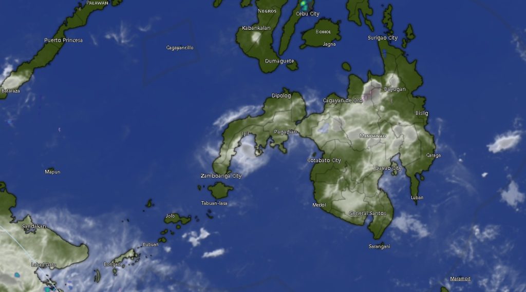
PAGASA’s Mindanao Regional Services Division (MINPRSD) said partly cloudy to cloudy skies will prevail across Mindanao from 5:00 a.m. Saturday, May 16, until 5:00 a.m. Sunday, with intermittent rain showers and thunderstorms expected in several provinces and highly urbanized cities.
Weather forecasters also warned of possible flash floods and landslides during severe thunderstorms, especially in low-lying and mountainous areas vulnerable to sudden heavy downpours.
Adding to the weather disturbance, PAGASA reported that the Low Pressure Area (LPA), formerly identified as “Caloy,” was estimated at around 1,055 kilometers east of Central Luzon as of 3:00 p.m. Friday. While the LPA is still far from the Philippine landmass, weather authorities continue to monitor its movement and possible development.
Across the Zamboanga Peninsula, including Zamboanga City, Zamboanga del Norte, Zamboanga del Sur, Zamboanga Sibugay, and Isabela City, residents can expect partly cloudy skies that may turn cloudy with rain showers and thunderstorms. Temperatures in the region are forecast to range from 24°C to 36°C, while coastal waters will remain slight to moderate with light to moderate winds coming from the southeast to southwest.
In Northern Mindanao, provinces such as Bukidnon, Camiguin, Lanao del Norte, Misamis Occidental, and Misamis Oriental are likewise expected to experience isolated thunderstorms throughout the day. Bukidnon may record temperatures as high as 36°C, among the warmest in the region.
Meanwhile, the Davao Region, including Metro Davao, Davao del Norte, Davao del Sur, Davao Oriental, Davao de Oro, and Davao Occidental, will continue to experience unstable weather conditions caused by localized thunderstorms. Daytime temperatures may range between 24°C and 34°C.
In the SOCCSKSARGEN Region, South Cotabato, Sultan Kudarat, Sarangani, and North Cotabato are also expected to experience occasional thunderstorms. North Cotabato may reach a maximum temperature of 36°C.
The Caraga Region, particularly Agusan del Norte, Agusan del Sur, Surigao del Norte, Surigao del Sur, and Dinagat Islands, will continue to experience similar weather patterns with isolated thunderstorms and moderate sea conditions.
In the Bangsamoro Autonomous Region in Muslim Mindanao (BARMM), including Cotabato City, Basilan, Lanao del Sur, Sulu, Tawi-Tawi, Maguindanao del Norte, and Maguindanao del Sur, cloudy intervals with rain showers and thunderstorms are likewise expected.
PAGASA said winds across Mindanao will generally remain light to moderate, blowing from the southeast to southwest, while coastal waters will stay slight to moderate with wave heights ranging from 0.6 to 1.2 meters.
Authorities advised residents, especially those living near rivers, mountain slopes, and flood-prone communities, to remain alert for possible flooding, landslides, and lightning hazards during severe thunderstorms.
PAGASA urged the public and local disaster risk reduction offices to continue monitoring official weather bulletins and advisories for updates regarding the LPA and localized thunderstorm activities.