
MINDANAO — Residents across Mindanao are advised to prepare for another day of unsettled weather as the Intertropical Convergence Zone (ITCZ) continues to affect the island, bringing cloudy skies, scattered rain showers and thunderstorms from Saturday, November 21, until Sunday morning, according to the Philippine Atmospheric, Geophysical and Astronomical Services Administration (PAGASA).
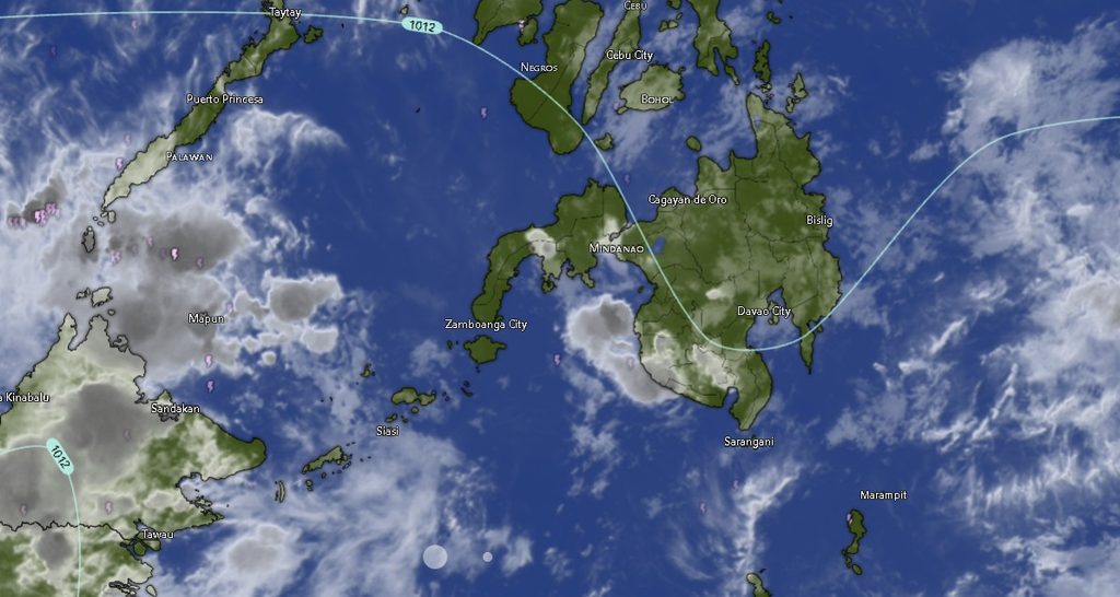
In its Regional Weather Forecast for Mindanao (MINPRSD), issued at 5:00 a.m. on November 21, PAGASA warned that moderate to, at times, heavy rainfall could trigger flash floods and landslides, particularly in areas vulnerable to flooding, soil erosion and rain-induced slope failures.
The weather disturbance is expected to affect the Zamboanga Peninsula, Northern Mindanao, Davao Region, SOCCSKSARGEN, Caraga and the Bangsamoro Autonomous Region in Muslim Mindanao (BARMM), with cloudy conditions and rain showers accompanied by thunderstorms forecast across the listed provinces and cities.
Widespread rainfall across Mindanao
In the Zamboanga Peninsula, Zamboanga City, Zamboanga del Norte, Zamboanga del Sur, Zamboanga Sibugay and Isabela City are expected to experience cloudy skies with rain showers and thunderstorms. Temperatures are forecast to range from 24°C to 33°C, depending on the locality and period.
Similar weather conditions are expected across Northern Mindanao, including Bukidnon, Camiguin, Lanao del Norte, Misamis Occidental and Misamis Oriental. Bukidnon is forecast to have relatively cooler temperatures, ranging from 19°C to 30°C, while coastal and lowland areas will experience temperatures reaching up to 33°C.
In the Davao Region, Metro Davao, Davao del Norte, Davao del Sur, Davao Oriental, Davao de Oro and Davao Occidental are also expected to experience cloudy skies, rain showers and thunderstorms.
Temperatures in the region will generally range from 23°C to 30°C, although some areas may experience slightly cooler conditions during the forecast period.
The same weather pattern is expected in SOCCSKSARGEN, covering North Cotabato, South Cotabato, Sultan Kudarat and Sarangani. Temperatures in these areas are projected to range from 23°C to 30°C.
Meanwhile, the Caraga Region, including Agusan del Norte, Agusan del Sur, Surigao del Norte, Surigao del Sur and the Dinagat Islands, will likewise experience cloudy skies with rain showers and thunderstorms. Temperatures are expected to range from 23°C to 33°C.
Across BARMM, Cotabato City, Basilan, Lanao del Sur, Sulu, Tawi-Tawi, Maguindanao del Norte and Maguindanao del Sur are also covered by the rainfall forecast. Temperatures in these areas are expected to range from 23°C to 33°C.
Flash floods and landslides among major concerns
PAGASA emphasized that moderate to, at times, heavy rainfall could result in flash floods and landslides, raising concerns for communities located near rivers, waterways, low-lying settlements and mountainous areas.
Residents are advised to remain alert, particularly during periods of persistent or intense rainfall. Communities in flood-prone locations should monitor water levels and be prepared to move to safer areas when necessary.
Motorists are also urged to exercise caution when traveling, as heavy rain can reduce road visibility, create slippery driving conditions and cause sudden flooding along roadways.
Local disaster risk reduction and management offices are encouraged to closely monitor weather developments and maintain readiness to respond to possible flooding, landslides and other rain-related emergencies.
Light to moderate winds, slight to moderate seas
PAGASA also forecast light to moderate winds coming from the east to northeast across the region.
Coastal waters are expected to remain slight to moderate, with wave heights ranging from 0.6 to 2.1 meters. While these conditions are generally less disruptive than rough or very rough seas, fishermen, boat operators and other maritime travelers are advised to remain cautious, particularly during thunderstorms and periods of reduced visibility.
Weather outlook through Sunday morning
The regional forecast is valid from 5:00 a.m. on November 21 until 5:00 a.m. on November 22, 2026.
The continuing influence of the ITCZ means that rainfall and thunderstorms may affect different parts of Mindanao throughout the forecast period. Residents should not assume that temporary improvements in weather conditions mean the threat of heavy rainfall has completely passed.
PAGASA urged the public to stay updated through official weather advisories and bulletins, especially those issued by local authorities in areas vulnerable to flooding and landslides.
For additional weather information and inquiries, the public may contact PAGASA through 8922-1992 and 8927-1335 or visit its official website at bagong.pagasa.dost.gov.ph.