
EL SALVADOR CITY, Misamis Oriental — Most parts of Mindanao will experience partly cloudy to cloudy skies with isolated rainshowers and localized thunderstorms over the next 24 hours, with the Philippine Atmospheric, Geophysical and Astronomical Services Administration (PAGASA) warning that severe thunderstorms could trigger flash floods and landslides in vulnerable areas.
The weather outlook was issued by the PAGASA Mindanao Regional Services Division (MINPRSD) at 5:00 a.m. on August 23, 2026, and is valid until 5:00 a.m. on August 24.
PAGASA said a localized thunderstorm is affecting Mindanao, resulting in generally unsettled weather conditions across the region.
While widespread heavy rainfall is not forecast across the entire island, localized thunderstorms may develop over different areas during the forecast period. PAGASA cautioned that intense thunderstorms could produce sudden heavy downpours, increasing the risk of flash floods and rain-induced landslides, particularly in low-lying, flood-prone and mountainous communities.
Residents are advised to remain alert to rapidly changing weather conditions, especially when thunderstorms develop in their areas.
Southwesterly winds, moderate seas
Winds across Mindanao are expected to remain light to moderate from the south to southwest, while coastal waters are forecast to be generally slight to moderate, with wave heights ranging from 0.6 to 2.1 meters.
The conditions may still affect small fishing boats and other vessels, particularly when thunderstorms develop over coastal waters.
Temperatures to reach as high as 35°C
Despite the possibility of rain and thunderstorms, daytime temperatures across Mindanao are expected to remain warm.
In the Zamboanga Peninsula, temperatures are forecast to reach up to 32°C in Zamboanga City, 32°C in Zamboanga del Norte, and 30°C in both Zamboanga del Sur and Zamboanga Sibugay during the initial forecast period.
The following period could bring warmer conditions, with maximum temperatures reaching 35°C in Zamboanga del Norte, 34°C in Zamboanga City and Isabela City, and 31°C in Zamboanga del Sur and Zamboanga Sibugay.
In Northern Mindanao, Bukidnon is expected to record temperatures between 20°C and 31°C, while Camiguin could reach 32°C and Lanao del Norte and Misamis Occidental up to 30°C during the first period. Temperatures could climb to between 32°C and 34°C in several areas during the succeeding period.
Across the Davao Region, temperatures during the first period are forecast at 22°C to 32°C, depending on the province, with some areas potentially reaching 34°C the following day.
In SOCCSKSARGEN, temperatures are expected to range from 22°C to 31°C, with maximum temperatures rising to around 31°C to 33°C in the succeeding forecast period.
The Caraga Region will also remain prone to isolated rainshowers and thunderstorms, with temperatures generally ranging from the low 20s to the mid-30s Celsius.
Meanwhile, areas in the Bangsamoro Autonomous Region in Muslim Mindanao (BARMM), including Cotabato City, Basilan, Lanao del Sur, Sulu, Tawi-Tawi, Maguindanao del Norte and Maguindanao del Sur, are likewise expected to experience partly cloudy to cloudy skies with isolated rainshowers or thunderstorms.
Temperatures in BARMM could reach 34°C in several areas during the latter part of the forecast period.
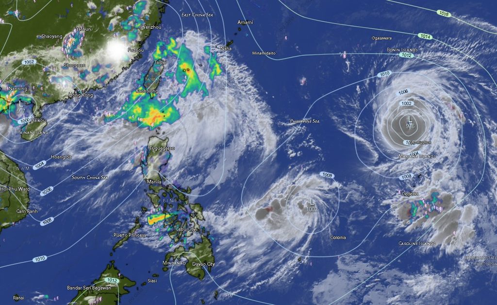
Three tropical cyclones being monitored outside PAR
PAGASA is also monitoring three tropical cyclones outside the Philippine Area of Responsibility (PAR) as of its latest tropical cyclone information.
The strongest among them is Typhoon Saudel (2618), which was located approximately 2,555 kilometers east of Northern Luzon, at 18.8°N, 145.9°E.
Saudel was packing maximum sustained winds of 150 kilometers per hour near the center, with gustiness of up to 185 kph. It was moving northwestward at 15 kph.
PAGASA was also monitoring a tropical depression located approximately 1,055 kilometers east of Eastern Visayas, at 11.6°N, 135.4°E. The system had maximum sustained winds of 45 kph, gustiness of up to 55 kph, and was moving northwestward at 30 kph.
Another system, Tropical Depression Gaenari, was located approximately 660 kilometers north-northeast of Itbayat, Batanes, at 26.1°N, 124.7°E.
Gaenari had maximum sustained winds of 55 kph, gustiness of up to 70 kph, and was moving slowly northwestward.
Despite the presence of these systems outside PAR, the immediate weather concern for Mindanao remains the development of localized thunderstorms, according to the regional forecast.
Authorities urge vigilance during thunderstorms
PAGASA’s warning of possible flash floods and landslides underscores the need for residents in vulnerable communities to remain vigilant, particularly when thunderstorms become severe.
Communities near rivers, creeks, waterways and steep or unstable slopes should monitor local weather conditions and be prepared to move to safer locations if flooding or landslides occur.
Motorists are likewise advised to exercise caution during sudden heavy rainfall, when reduced visibility and slippery roads can increase the risk of road accidents.
For coastal communities and maritime operators, the forecast of slight to moderate seas and possible thunderstorms means conditions can change rapidly. Fisherfolk and small-boat operators are encouraged to monitor weather updates before venturing offshore.
PAGASA’s MINPRSD forecast covers the entire Mindanao area, including the Zamboanga Peninsula, Northern Mindanao, Davao Region, SOCCSKSARGEN, Caraga and BARMM.
The agency reiterated that localized thunderstorms can develop quickly, making conditions vary significantly from one locality to another even when the general regional forecast calls for partly cloudy skies.
Residents are therefore urged to continue monitoring official PAGASA advisories and warnings, particularly if thunderstorms intensify in their communities.